

CITIES
iv. Modern Urbanization and Modernization in Persia
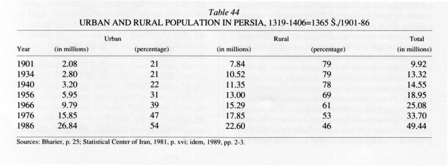
Over a period of decades the rapidly growing population of Persia has simultaneously become increasingly urbanized. More and more people live in increasingly larger cities, and the largest cities tend to grow at a rate above the average (see Table 44). These developments are connected with deep-seated changes not only in the physical appearance of the cities but also in their social and economic structures. Three general phases in the modern history of Persian cities can be distinguished: the traditional Persian city to about 1338/1920, the beginning of modern urbanization between 1338/1920 and 1339 Š./1960, and urban change and restructuring since 1339 Š./1960.
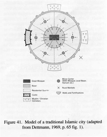
The traditional Persian city. The traditional Persian city typified what has been called the “Islamic city” (Hourani and Stern), the “Muslim city” (Gardet; von Grunebaum; Lapidus, 1967), and, more neutrally, the “Middle Eastern city” (Lapidus, 1969, and many others). The main characteristics of this type may be summarized as follows. The economic and social center of the city was the bāzār, which was very often located close to the main congregational (Friday) mosque (masjed-e jomʿa/jāmeʿ). Trade, commerce, and the crafts were organized on a core-periphery model: The most highly esteemed goods were sold in the center of the bāzār and adjacent to the mosque, whereas the traditional crafts were located on the outer periphery, along with the caravansaries, the focal points for overland trade and commerce. The bāzār was surrounded by residential quarters (maḥallas), generally separated from one another by walls and gates and housing homogeneous ethnic, religious, and/or professional groups. Each maḥalla had a small shopping area (bāzāṛča) and a mosque for the inhabitants. The entire city was surrounded by walls and accessible through fortified gates.
Figure 41 is a simplified descriptive model of the formal aspects of this traditional city. Although J. Abu-Lughod has recently argued convincingly that the esnāds (chains of authority) for this model are typical of Western academic orientalism and that they originated in French studies of North African and Syrian cities, nevertheless it fits Persian cities in most formal, social, and economic details. Historical descriptions and old drawings, as well as geographical reconstructions, provide many examples of the validity of the model: Isfahan (Gaube and Wirth), Kāšān (Costello), Kermān (English), Kermānšāh (Clarke and Clark), Malāyer (Momeni), Mašhad (Pagnini-Alberti), Shiraz (Clarke and Clark), Ṭabas (Ehlers, 1977), and Tehran (Seger, 1978).
The beginnings of modern urbanization. The first steps toward a restructuring of the traditional Persian city were taken in the 13th/19th century, but only in Tehran, which, especially under Nāṣer-al-Dīn Shah (1264-1313/1848-95), experienced the beginnings of modernization and “Europeanization.” Under the impetus of incipient industrialization, the population grew rapidly, and the expansion of both traditional and modern residential quarters was correspondingly rapid. The old ditch surrounding the city was filled in, and the city wall constructed in 960/1553 was replaced in 1290/1873 by a new wall, octagonal in plan with twelve gates, which was modeled after the fortifications of Paris. This new wall, which was almost three times as long as its predecessor, enclosed an area about 20 km2. Modernization began with the construction of boulevards in the newer parts of the city, and modern facilities for administration, education, industry, and trade and commerce were introduced. Other Persian cities were rarely affected, however. As can be seen in Table 44, there were only minor changes in the rural-urban distribution of the Persian population between the beginning of the 14th/20th century and the outbreak of World War II. On the other hand, during the same period Persian cities grew more rapidly (54 percent) than did rural areas (45 percent), owing partly to the superior social infrastructure and resulting longer life expectancy for newborns and partly to steadily increasing migration from rural areas.
The large-scale program for urbanization and modernization adopted under Reżā Shah (r. 1304-20 Š./1925-41) involved mainly superimposing new urban layouts and street patterns on traditional city cores, the expansion of older cities, and the construction of new ones (Mostawfī, III, pp. 243-51; Marefat, pp. 80-94). In a letter dated 21 Āḏar 1310 Š./12 December 1931, the Ministry of the interior sent detailed instructions to the engineers, planners, and architects charged with renovating the old city center and immediately adjacent areas of Malāyer. The width of the main thoroughfare was to be 16 m, that of the gutters (jūbs) on each side 0.5 m, and that of the sidewalks 3.5 m, for a total width of 24 m. The circular central meydān (open space) was to have a radius of 16 m, surrounded by an inner sidewalk 3.5 m wide, an inner jūb 3.5 m wide, a street 16 m wide, an outer jūb 0.5 m wide, and an outer sidewalk 3.5 m wide. The streets and the meydān were to be on exactly the same level. The buildings around the meydān and along the streets were to be uniform, and the ground floors were to be strong enough to support second stories. Each shop was to have a frontage of no less than 3.5 m; the foundation walls were to be 0.75 m thick and sunk 1 m deep, the upper walls at least 0.3 m thick. The entrance door was to be 2.5 m high and made from the wood of plane trees, and there was to be a glazed inner door. The height of the ground floor was to be 4 m, that of the second floor 3.5 m. Trees were to be equally spaced along the streets and around the meydān. The surfaces of the streets were to be slightly convex so that rain and snow would run off into the gutters. The bricks used for the curbs, the facades of the shops, and all buildings were to measure 9 x 4.5 x 3 inches (Momeni).
This example reveals several typical features of Reżā Shah’s urban-renewal policy. Because both the layout and the design of the streets were planned by the central administration, the remodeled sections of the various cities exhibited considerable architectural uniformity, characterized by two-story buildings around a central meydān, often occupied by such public services as the municipal administration, banks, and the police. Along the new avenues (ḵīābān) shops predominated; they were painted in uniform colors (often yellow or blue), and their facades were frequently enhanced with neoclassical columns. The entrances and windows of houses were often framed by stucco decorations, and small turrets and blind arcades all contributed to what has been called the “Pahlavi style” (Marefat, pp. 81-92).
The unprecedented increase in the urban population that began in the 1310s Š./l930s (Table 44) led to the construction of new residential quarters adjacent to traditional city centers. The major east-west and north-south traffic arteries superimposed on the urban cores served as axes for street grids that were extended into the new residential areas. These new quarters differed considerably in both form and function from the dense and heavily populated older portions of the cities, with their traditional sun-dried brick or even mud architecture. The new quarters very often developed in concentric rings around the older centers; one- or two-story buildings constructed of baked bricks and covered with flat tin roofs predominated. Although the ground plans and architectural details were adapted from Western patterns, such basic features as windowless facades and interior arrangements centered on small gardens remained generally unchanged. In the largest cities two- and three-story buildings with rental flats were also common. Again a certain uniformity prevailed in the new quarters and expanded cities in general (Marefat, pp. 153-232).
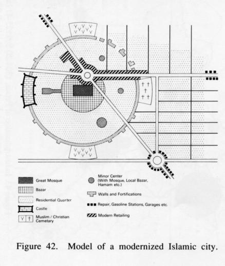
A schematic diagram of the characteristic city of the 1310s Š./1930s and early 1320s Š./1940s (Figure 42) reveals an already fairly well-developed dualism in the structure of the city, not only in layout, building materials, and architectural details, but also in social and economic structure. The main force for expansion of the older cities was not migration from rural areas but rather intra-urban shifts. For example, many of the new quarters were built and financed by such urban notables as merchants from the bāzārs and urban-based rural landlords (mālekān). They invested money in real estate, moved out of the old city quarters, and settled in the new quarters. Their old residences then often became shelters for rural immigrants. As a consequence, quite a few of the traditional maḥallas experienced social and economic decline, especially when residential expansion was accompanied by a shift in the commercial centers and development of new, Western-style shopping districts (cf. Momeni; Rist, 1979; idem, 1981; Bobek).
Aside from modernization, restructuring, and extension of existing urban centers, Reżā Shah’s development policies encouraged the foundation of new cities as centers for both administration and modern industry. Apart from Ābādān, Āḡā Jārī, Ahvāz, Bandar-e Māhšahr, Behbahān, Haft-Gel, Masjed-e Solaymān, Qaṣr-e Šīrīn (qq.v.), and other cities connected with the oil industry (Bharier, p. 28), most new towns grew out of pre-existing villages and were often intended to shelter only a few administrative services, like schools, hospitals, police and gendarmerie stations, and banks, as well as facilities for the private sector. New towns of this type were located primarily in sparsely populated areas that lacked sufficient infrastructure or in parts of the country where existing services were not appropriate to local needs.
These new service centers were, of course, even more dominated by the Pahlavi style of architecture than the older ones. Studies conducted in different parts of Persia, for example, Bam (Ehlers, 1975), Sīrjān (Rist, 1979), Ṭabas (Ehlers, 1977), and Zābol (Rist, 1981), reveal that official planning principles tended to produce a more or less ubiquitous type of urban structure, which was especially apparent in smaller towns and cities. Even today most Persian cities bear the ineradicable imprint of Reżā Shah’s urban policy, characterized by a pervasive dualism.
Urban change and restructuring after World War II. Immediately after World War II economic stagnation brought about a recession and a pause in urban restructuring. But in the late 1330s Š./1950s and especially after about 1340 Š./1960 urban development gained new impetus from a sharp rise in urban population, measured both in absolute terms and as a percentage of total population (Table 44). Again there were three main aspects of urban change: development of new quarters, infrastructural and industrial changes, and urban-renewal programs.
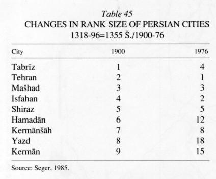
The year 1339 Š./1960 opened an era of unprecedented dynamism in urban growth. All towns—from the smallest rural center to the international metropolis that Tehran had become—experienced residential and commercial development. On the principle that “the bigger the city the faster its growth,” it was mainly Tehran and the provincial capitals that experienced the most dramatic increases in population and concomitant expansion of their urban boundaries. In a study based on statistical data covering the decades 1335-55 Š./1956-76 M. Seger (1985) provided a revealing analysis of the central-place hierarchy in Persia, distinguishing six levels: (1) the metropolis, Tehran; (2) first-rank provincial capitals like Isfahan, Tabrīz, and Mašhad; (3) second-rank provincial centers like Shiraz, Bāḵtarān (Kermānšāh), Ahvāz, Ābādān, and Rašt; (4) third-rank provincial centers like Yazd, Hamadān, Kermān, Urmia, Ḵorramšahr, and Qom; (5) medium-sized regional centers like Zākedān, Zanjān, Sanandaj, Ḵorramābād, Semnān, comprising also two subdivisions: (a) fourth-rank provincial centers like Ardabīl, Qazvīn, Arāk, Kāšān, Karaj, Ray, Anzalī, Gorgān, Borūjerd, Sārī, Šahr-e Kord, Bandar-e ʿAbbās(ī), and Būšehr and (b) other medium-sized cities like Dezfūl, Masjed-e Solaymān, Āmol, Bābol, Šāhī, Varāmīn, Sabzavār, Nīšāpūr, Šāhreżā, Ḵᵛoy, and Marāḡa; (6) small urban centers. The changes in rank size that took place between 1318/1900 and 1355 Š./1976 are of special relevance to the question of urbanization and modernization (see Table 45). Although the comparison covers only the nine leading centers of Persia in 1318/1900 and although some of the major changes occurred only after 1323 Š./1945, Table 45 does provide proof that it was the five leading centers that experienced the most extreme growth and spatial expansion after about 1339 Š./1960. Other urban centers also experienced a boom in both population and the development of infrastructure.
The new urban quarters that have come into existence since about 1340 Š./1960 are entirely dominated by Western-style architecture and infrastructural features. Department stores, cinemas, and various kinds of public facilities have become typical, not only of the national metropolis and leading provincial centers, but also of minor cities and towns, though often in reduced form. Such development enhanced the contrast between the older parts of the cities, which were often economically and socially stagnant, and modern, Western-style suburbs. This dualism reached a peak immediately before the Revolution of 1357 Š./1978-79 (Seger, 1975; idem, 1978).
In Persia urbanization has always been connected with industrialization, which has in fact been the precondition and precursor of modernization in other spheres of daily life. As new industries were located almost exclusively in already existing cities, it was there that social and economic modernization began. In the early phase of industrialization, based on oil (e.g., in Ābādān) and textiles, especially cotton, only a few new centers were developed.
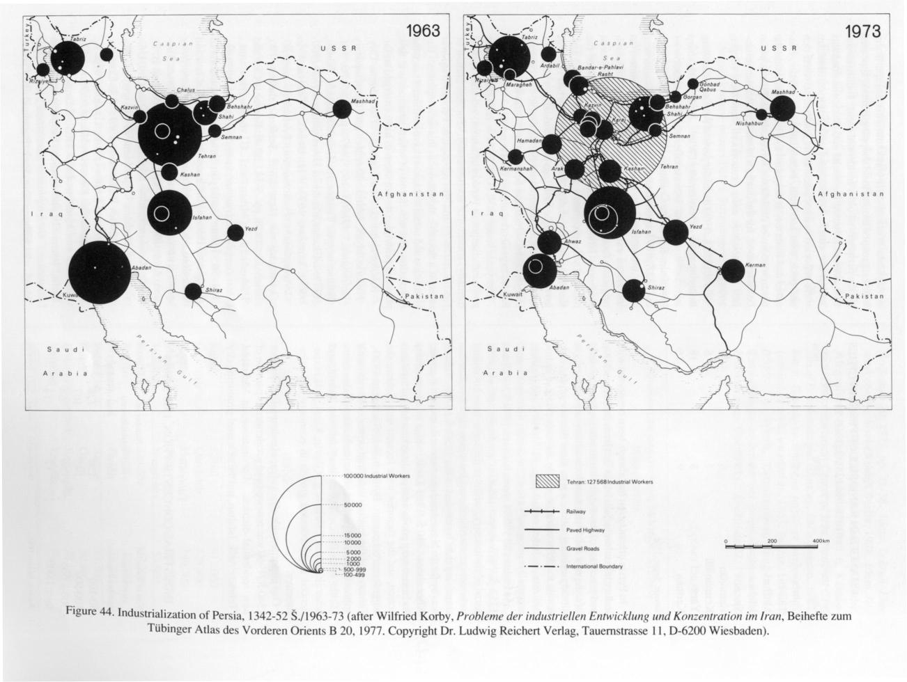
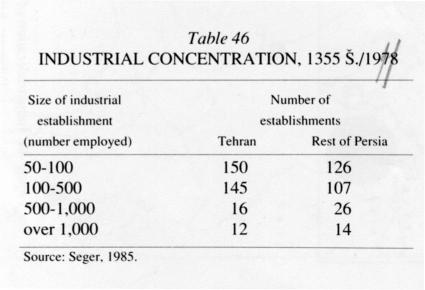
As Figure 43 and Figure 44 show, between 1304 Š./1925 and 1352 Š./1973 industrialization gradually spread to all parts of the country, while at the same time becoming more concentrated in the capital region. It is therefore not surprising that, by the end of the 1350s Š./1970s, Tehran was by far the biggest and most versatile industrial center. After about 1340 Š./1961 a wide range of commodities and investment goods were produced in addition to oil and cotton, and the factories were located near Tehran, the biggest market center. By the mid-1350s Š./mid-1970s, Tehran was the leading industrial center of Persia, with approximately 50 percent of the total national labor force (Table 46). Beside Tehran itself Isfahan, Tabrīz, and other cities near Tehran (e.g., Qazvīn, Karaj, Arāk) experienced unprecedented growth in economy and infrastructure.
One important side effect of rapid industrialization after 1340 Š./1961 was renewed and accelerated expansion of new residential districts. For instance, in Mehrābād (Tehran), Arāk, Isfahan, and the new steel-producing city of Āryāšahr (now Fūlādšahr) Western-style condominiums and apartment houses, grouped around local shopping centers, appeared on the periphery of older residential areas. Industrialization also accentuated the social and economic contrasts within the cities. Architectural and historical dualism were reflected in a socioeconomic dualism between rich and poor, villa and slum, industrialist and worker, educated and illiterate. It is against this background that the confrontations of the Islamic Revolution in Tehran are to be understood, for the dualism of modern Persian urbanism was nowhere more pronounced than there (Seger, 1978).
Until 1352 Š./1973 the older parts of Persian cities were decaying more or less rapidly (Wirth, 1968). The sharp increase in national income after the Organization of Petroleum-Exporting Countries (OPEC) raised oil prices in 1352 Š./1973, combined with a new national awareness of the urban heritage, led the Persian government to initiate an extensive urban-renewal program. Though originally focused primarily on such historical and tourist centers as Isfahan and Shiraz, in the last years of the monarchy the program was extended to cities like Yazd, Kermān, and especially Mašhad. Often urban renewal involved only single buildings or historically or architecturally significant urban ensembles in the old city centers. Only Isfahan, which had been the last Safavid capital of Persia, experienced almost total renewal.
The years since 1352 Š./1973 have brought the most profound changes in Persian urbanism, whether viewed formally, socially, or economically. The Revolution of 1357 Š./1978-79 and the subsequent Persian-Iraqi war brought a decisive slowdown in this development. Urbanization and urban expansion have continued since the Revolution, but new forms of urban structure and new planning principles do not seem to have emerged so far.
Bibliography:
J. Abu Lughod, “The Islamic City. Historic Myth, Islamic Essence, and Contemporary Relevance,” IJMES 19, 1987, pp. 155-76.
H. Bahrambeygui, Tehran. An Urban Analysis, Tehran, 1977.
J. Bharier, Economic Development in Iran 1900-1970, London, 1971.
H. Bobek, “Teheran,” in Geographische Forschungen. Festschrift zum 60. Geburtstag von Hans Kinzl, Schlern-Schriften 190, Innsbruck, 1958, pp. 5-24.
M. E. Bonine, “City and Hinterland in Iran,” in G. Schweizer, ed., Interdisciplinäre Iranforschung, Wiesbaden, 1979, pp. 141-56.
Idem, “Aridity in Structure. Adaptations of Indigenous Housing in Central Iran,” in K. N. Clark and P. Paylore, eds., Desert Housing. Balancing Experience and Technology for Dwelling in Hot Arid Zones, Tucson, Ariz., 1980, pp. 193-219.
J. I. Clarke and B. D. Clark, Kermanshah. An Iranian Provincial City, University of Durham, Department of Geography, Research Paper Series 10, Durham, 1969. V. F. Costello, Kashan. A City and Region of Iran, London, 1976.
K. Dettmann, Damaskus. Eine orientalische Stadt zwischen Tradition und Moderne, Ph.D. Diss., Erlangen, 1967.
Idem, “Islamische und westliche Elemente im heutigen Damaskus,” Geographische Rundschau 21, 1969, pp. 64-68.
E. Ehlers, “Die Stadt Bam und ihr Oasen-Umland/Zentraliran. Ein Beitrag zur Theorie und Praxis der Beziehungen Ländlicher Räume zu ihren kleinstädtlichen Zentren im Orient,” Erdkunde 29, 1975, pp. 38-52.
Idem, “City and Hinterland in Iran. The Example of Tabas/Khorassan,” Tijdschrift voor economische en sociale geografie 68, 1977a, pp. 284-96.
Idem, “Dezful und sein Umland. Einige Anmerkungen zu den Umlandbeziehungen iranischer Klein- and Mittlestädte,” in G. Schweizer, ed., Beiträge zur Geographie orientalischer Städte und Märkte, Wiesbaden, 1977b.
P. W. English, “Die Auswirkungen neuzeitlicher Strömungen auf eine alte persische Minderheit,” Bustan 4, 1966, pp. 18-23.
L. Gardet, “La cité musulmane. Vie sociale et politique,” in Études musulmanes I, 4th ed., Paris, 1976.
H. Gaube and E. Wirth, Der Bazar von Isfahan, Tübinger Atlas des Vorderen Orients, Beihefte B/22, Wiesbaden, 1978.
G. E. von Grunebaum, “The Structure of the Muslim Town,” in Islam. Essays on the Nature and Growth of a Cultural Tradition, Ann Arbor, Mich., 1955, 2nd ed., London, 1961, pp. 141-58.
A. H. Hourani and S. M. Stern, eds., The Islamic City. A Colloqium, Papers on Islamic History 1, Oxford, 1970.
H. Kopp, “Sārī. Entwicklung und gegenwärtige Struktur einer iranischen Provinzhauptstadt im Kaspitiefland,” in G. Schweizer, ed., Beiträge zur Geographie orientalischer Städte and Märkte, Wiesbaden, 1977.
W. Korby, Probleme der industriellen Entwicklung und Konzentration in Iran, Tübinger Atlas des Vorderen Orients, Beihefte B/20, Wiesbaden, 1970.
I. M. Lapidus, Muslim Cities in the Later Middle Ages, Cambridge, Mass., 1967.
Idem, ed., Middle East Cities. A Symposium on Ancient Islamic and Contemporary Middle Eastern Urbanism, Berkeley and Los Angeles, 1969.
Idem, “The Evolution of Muslim Urban Society,” Comparative Studies in Society and History 15, 1973, pp. 21-50.
M. Marefat, “Building to Power. Architecture of Tehran. 1921-1941,” Ph.D. Diss., Cambridge, Mass., 1988.
M. Momeni, Malayer und sein Umland. Entwicklung, Struktur und Funktionen einer Kleinstadt in Iran, Marburger Geographische Schriften 68, Marburg, 1974.
ʿA. Mostawfī, Šarḥ-e zendagānī-e man III, Tehran, 1343 Š./1964.
M. P. Pagnini Alberti, Strutture commerciali di una città di pelligrinaggio. Mashhad (Iran nord-orientale), University of Trieste, Istituto de Geografia, Pubblicazione 8, Udine, 1971.
B. Rist, “Die Stadt Sirjan und ihr Hinterland,” in E. Ehlers, ed., Beiträge zur Kulturgeographie des islamischen Orients, Marburger Geographische Schriften 78, Marburg, 1979, pp. 111-39.
Idem, Die Stadt Zabol. Zur wirtschaftlichen und sozialen Entwicklung einer Kleinstadt in Ost-Iran (Sistan-Projekt I), Marburger Geographische Schriften 86, Marburg, 1981.
K. Scharlau, “Moderne Umgestaltungen im Grundriss iranischer Städte,” Erdkunde 15, 1961, pp. 180-91.
M. Seger, “Strukturelemente der Stadt Teheran und das Modell der modernen orientalischen Stadt,” Erdkunde 29, 1975, pp. 21-38.
Idem, Tehran. Eine stadtgeographische Studie, Berlin, 1978.
Idem, Die zentralörtliche Typisierung der iranischen Städte, Klagenfurter Geographische Schriften 6, Klagenfurt, 1985.
Statistical Center of Iran, National Census of Population and Housing, 1976, Tehran, 1981.
Idem, Gozīda-ye natāyej-e tafṣīlī-ye saršomārī-ye ʿomūmī-ye nofūs wa maskan, 1365, Tehran, 1367 Š./1989.
E. Wirth, “Strukturwandlungen und Entwicklungstendenzen der orientalischen Stadt. Versuch eines Überblicks,” Erdkunde 22, 1968, pp. 101-28.
(Eckart Ehlers)
Originally Published: December 15, 1991
Last Updated: October 21, 2011
This article is available in print.
Vol. V, Fasc. 6, pp. 623-629