

CHITRAL (Čitrāl), river valley in the upper Indus system.
The Chitral river drains the eastern Hindu Kush in the north and a spur of the Hindu Raj on the south and east. With its deeply incised bed and braided stream channels it constitutes the upper tract of the Kunar (Konar), which debouches into the Kabul river, a tributary of the Indus, just below Jalālābād in Afghanistan. The Chitral valley, 300 km long and at its widest no more than 100 km, is one of the more remote valleys of Kohestan (Kūhestān), a broad strip of territory extending from near Kabul to the plain of Kashmir (see Figure 37). It now constitutes an administrative district (14,850 km2) of the North-West Frontier Province of Pakistan; it comprises six minor civil divisions (taḥṣīls), delineated according to tributary valleys: Chitral, Drosh (Dūrošt), Lutkho (Loṭkuh), Mulkho (Moḷikho), Turkho (Torikho), and Mastuj (Mastūj). The Chitral valley, which is bounded by mountain ranges in which many peaks reach 5,000-6,000 m, can be entered only by following the riverbanks upstream or by crossing several high passes. The latter include the Dorah (Dūrāh) from Badaḵšān in Afghanistan, the Baroghil (Barūγīl) from the Wāḵān corridor, the Darkot (Darkūt) from Yasin (Yāsīn) and the Shandur (Šandūr; 3,720 m) from Gilgit in Pakistani-controlled Jammu and Kashmir, and the Lowarai (Lowarāʾī, 3,118 m), from the neighboring administrative district of Dir (Dīr) on the south, all at elevations above 3,000 m. The location of Chitral at the point where Central Asia, Inner Asia, and South Asia meet is reflected in its heterogeneous population. A dozen languages are spoken, reflecting both ancient indigenous elements and later arrivals (see ii, below). A dynasty claiming descent from the Mughal emperor Bābor (932-37/1526-30) ruled there until 1974, when the principality was eliminated by the Pakistani government.
Natural environment. Chitral lies along the western edge of the Kohestan geological “island,” between the Gondwana and Eurasian tectonic plates. Seismic disturbances are frequent, bringing severe destruction and loss of life. Most precipitation falls as snow in the high mountains and is sequestered in glaciers and snowfields, which cover almost the entire northern boundary of the valley, defined by the mountains and high passes along the crest of the Hindu Kush from Tirich Mir (7,706 m), the highest mountain in Chitral, to the Baroghil pass (3,804 m), a total of 10 percent of the territory of Chitral district. The Chiantar glacier at the head of the Yarkhun (Yarḵūn) river is the longest (32 km) in the district; twenty-one others exceed 10 km in length. In these subtropical latitudes strong solar radiation at the highest altitudes creates large areas of jagged firn, known in German as Büsserschnee (lit. “penitential snow,” referring to the resemblance of the refrozen snow to the conical hoods of penitents). The valley itself is semiarid. Monsoon winds sometimes blow in southern Chitral, but resulting rainfall is negligible; summer rain comes from occasional westerly cyclonic storms and convectional clouds. The primary source of water for irrigation, however, is meltwater from the mountains, especially in the Yarkhun and tributary Turkho river basins. Annual-precipitation records at Drosh (608 mm) and Chitral (448 mm) in the arid lower valley are misleading, as they do not include the water derived from snowfall in the mountains. Recent estimates for the adjacent Karakoram range suggest that meltwater amounting to 30 dm a year is accumulated in mountains above 6,000 m. The Chitral river reaches its peak flow of 26:1 in July and its lowest point in winter, reflecting seasonal snowmelt. Flowing glaciers generate much rock flour, and the meltwater that pours into the upper Chitral contains a concomitant heavy load of suspended sediment. For irrigation purposes, the river water must be held in tanks, where the sediment settles.
Owing to both complex topography and resulting varied exposure, the vegetation pattern of Chitral is also complex. Below the snowline, which lies at about 5,200 m, there are two distinct tree lines; the higher, at 3,400 m, marks the elevation above which constant freezing prevents the growth of trees; the lower, at 1,800 m, is the elevation below which the valley is too arid for large stands of trees. Above the confluence of the Turkho and Yarkhun rivers artemisia steppe prevails, with occasional juniper, though artemisia shrubs are found throughout the vegetation cline. The villagers also grow fodder trees like willow, poplar, and Russian olive, and tamarisk is often found along watercourses. Most of the forests or forest remnants are found in the better-watered valleys converging on the lower course of the Chitral river. In southern Chitral tree species range from degraded holly-oak forest, often used for fodder, at the lowest elevations; through neozas (Pinus gerardiana),which yield pine nuts for human consumption, deodar cedars (Cedrus deodara) and blue pine (Pinus excelsa); to fir, spruce, and birch. Fruit and nut trees are grown throughout southern Chitral up to 2,800 m, depending upon the exposure. They provide an important component of the local diet, and some, like mulberry and walnut, are vital to human survival during the season of low water. Plant growth is sometimes impeded by strong anabatic winds that in summer blow daily in the lower reaches of the valley close to the Jalālābād plain. Only intensive labor can render the local soils suitable for cultivation.
Wildlife is still found throughout the valley, though much depleted by human depredation. Chitral is the last refuge of the mountain goat markhor (Capra falconieri); Chitral Gol, the hunting preserve of the former ruler of Chitral, has been converted into a wildlife preserve, where considerable numbers of markhor, Siberian ibex, and the even rarer snow leopard (Felis uncia) survive. Urial and Marco Polo sheep (Ovis vignei and Ovis poli respectively) are no longer found in upper Chitral, though brown bears are still occasionally sighted there. Black bears are known in a few places in the southern valley. Such large and distinctive forest birds as Lady Impey’s pheasant inhabit the drier northern reaches of the valley.
History. In antiquity there was considerable traffic from Badaḵšān through the Dorah pass, across southern Chitral, and through the Lowarai pass to the ancient Buddhist monasteries in Swat. Although little is known of the medieval history of the area, in the 4th/10th century it was subject to the king of Kabul. In the 10th/16th century Chitral became a princely state under the rule of a dynasty of mehtars (lit. “elders”). Slave trading was the principal source of income for these Kushwaqt rulers of Chitral and neighboring Gizar and Yasin; slaves were supplied particularly to Badaḵšān and southern Kashmir. From early in the 13th/19th century and the beginning of the “Great Game”—the geopolitical rivalry between the Russians and the British in Central and Inner Asia—Chitral was a focal point for Indian imperial attention. Large topographic surveys of the British Indian frontier indicated that no tsarist army could successfully penetrate through the Hindu Kush to the Indus plains with field guns. In 1297/1880, at the conference of Zemma (near Kabul), the British installed ʿAbd-al-Raḥmān Khan as the first amir (r. 1297-1319/1880-1901) of the modern state of Afghanistan. His active policy of converting the indigenous population of the central Hindu Kush, that is, Kafiristan (now Nūrestān/Nuristan), to Islam brought a virtual halt to traffic up the Konar river. In 1889 Chitral came under the control of Indian imperial forces supplied from Malakand (Malākand) south of the Lowarai pass. Their hegemony was ensured by the establishment of the boundary with Afghanistan (the Durand Line) in 1311-12/1893 (See boundaries iii. boundaries of afghanistan). Roads and mule tracks were constructed by the British both before and after the final demarcation of the border by the Pamir boundary commission in 1895. In the same year two local princes laid siege to the British garrison in the fort at Chitral, which was relieved by imperial troops who crossed the Shandur pass from Gilgit. After the partition of India in 1948 the mehtars continued to rule nominally, under Pakistani control. Since 1974 Chitral has been administered directly by the Pakistani government from the provincial capital at Peshawar. Today access to Chitral district is by gravel road through the Lowarai pass, which is, however, closed by winter snows. A track for vehicles with four-wheel drive links Mastuj district with Gilgit through the Shandur pass. Daily air service is also available between Peshawar and the town of Chitral. Although urban development in the valley is negligible, there are small bāzārs in Drosh, Ayun, and Chitral, where the old British fort and cantonment still stand.
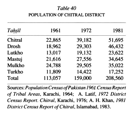
Population and cultural geography (see Table 40). The present population of Chitral belongs to four language groups (see ii, below). The most ancient stratum, in the southern part of the valley, includes the four “Dardic,” or, rather, Kohestani, languages. In the early 13th/19th century Sunni clerics began to penetrate Chitral from the south, through the Lowarai pass, and Sunni Muslims still predominate in the population of the southern valley. Ismaʿili Shiʿites from Badaḵšān were active among the predominantly Buddhist and pagan population in the early Islamic period. Today Ismaʿili villages are found exclusively in the Turkho and Yarkhun valleys extending down to central Chitral. The inhabitants speak Wakhi, a Persian language related to that of the Tajiks in Gorno-Badakhshan Autonomous Oblast of the Tajik Soviet Socialist Republic and in the Sarikol area of Tajik Autonomous County of Sinkiang (Xin jiang) Uighur Autonomous Region in the People’s Republic of China. A similar population inhabits Gujal taḥṣīl in northern Gilgit. A group of transhumant Gujars occupies the southern mountain slopes. Finally, since the beginning of civil war in neighboring Afghanistan in 1357 Š./1978 substantial numbers of refugee Tajiks, Nuristanis, and Pashtuns, including Shiʿites, have settled in semipermanent camps in Chitral and the neighboring Lutkho and Drosh districts.
There are also a few non-Muslims in Chitral, including especially the “Kalash Kafirs,” numbering only about 3,000; they live in the Berer, Bomboret, and Rumbur valleys along the right bank of the Chitral river contiguous with the Afghanistan border. They are polytheistic and constitute the last remnant of the religious and social group that predominated from Kohestan to Kabul before the coming of Islam. In 1314/1896, under the aegis of ʿAbd-al-Raḥmān Khan, the Kafirs in the Afghan tributary valleys of the Konar—the Bashgul (Bašī Gol), Pēč, Waigul (Wāīgol), Parun (Pārōn), and Kantiwo (Kāntiwō)—were forcibly converted to Islam. Missionaries from Deoband in Uttar Pradesh, India, are now actively proselytizing among those who remain in Chitral.
Economic life. Agriculture and pastoralism are the principal means of livelihood in Chitral valley. The location of almost all settlement is determined by access to reliable sources of water, either natural streams or artificial leats; in fact, the settlement boundaries are defined and circumscribed by irrigation works. Agricultural villages are usually located near points of water distribution at the apexes of alluvial fans. When the exposure is favorable double cropping is possible up to 2,200 m. Harvesting of early crops is usually concluded in early May in the southern Chitral valley, which permits sowing and harvesting of another crop before the winter cold. Traditional field crops included rice, wheat, sweet and bitter buckwheat, millet, and broad beans. By 1990, however, much of the land in the south had been shifted to cultivation of corn and in the north, at elevations above the rice-growing area, potatoes. Potato production increased ninefold in the 1980s, as the crop can often be cultivated up to 3,200 m. Rural incomes are further enhanced by opium production and manufacture of hashish from cannabis plants (see bang).
Animal husbandry follows the Almwirtschaft (“family economy”) model, with livestock being moved vertically from permanent quarters to traditional alpine pastures by members of the family. There is no nomadism in Chitral, but in the lower reaches of the valley transhumant Gujars lease pastures from the inhabitants. Goats are most popular, for they provide hides, hair, meat, milk, and especially dung. According to ancient mountain custom, only men milk goats, for the goat and its wild relative the ibex are subject to religious taboos that are known throughout the Eurasian mountains. Homespun clothing is produced from sheep’s wool. Yaks are found in the upper Yarkhun valley, where they are used as pack animals and for meat. Wild animals once provided a convenient source of meat, but hunting has been curtailed by conservation authorities.
In the remote valleys tourism, trekking, and climbing provide additional sources of income for villagers, who act as porters and guides. Ancillary benefits have included information on geology, snow, and ice hydrology. Further extension of tourism is limited by poor transportation networks and facilities and the absence of accommodations.
Bibliography:
G. J. Alder, British India’s Northern Frontier 1865-95. A Study in Imperial Policy, London, 1963.
N. J. R. Allan, “Ecological Effects of Land Intensification in the Central and Eastern Hindukush,” in E. Grötzbach and G. Rinschede, eds., Beiträge zur vergleichenden Kulturgeographie der Hochgebirge, Regensburg, 1984, pp.193-212.
Idem, ed., When Three Empires Meet. Hindukush, Karakorum, and Himalaya Societies in Transition, in press, 1991.
A. Aleem, “Markhor Population Dynamics and Food Availability in Chitral Gol Game Sanctuary,” Pakistan Journal of Forestry 27/2, 1977, pp. 86-92.
A. J. Barker, Townshend of Kut, London, 1967.
A. R. Beg and A. S. Khan, Flora of Malakand Division, Peshawar, 1974.
H. W. Bellew, Kashmir and Kashgar, London, 1875.
W. G. L. Beynon, With Kelly to Chitral, London, 1896.
J. Biddulph, The Tribes of the Hindoo Koosh, Calcutta, 1880.
D. Braslau, “Climbs in Swat-Kohistan and Chitral,” New Zealand Alpine Journal 17, 1958, pp. 287-92.
M. F. Buchroithner and H. Gamerith, “On the Geology of the Tirich Mir Area, Central Hindu Kush (Pakistan),” Jahrbuch der Geologischen Bundesanstalt, Wien 128, 1985, pp. 367-81.
M. F. Buchroithner and R. Kostka, “Zur Herstellung einer topographisch-thematischen Karte des Tirich Mir Gebietes (Hindukusch),” Kartographische Nachrichten 36, 1986, pp. 171-79.
J. A. Calkins et al., Geology and Mineral Resources of the Chitral-Partsan Area, Hindu Kush Range, Northern Pakistan, U.S. Geological Survey Professional Paper 716-G, Washington, D.C., 1981.
I. I. Chaudhri, “A Contribution to the Flora of Chitral State,” Pakistan Journal of Forestry 7, 1957, pp. 170-76.
G. Cockerill, “Pioneer Exploration in Hunza and Chitral,” Himalayan Journal 11, 1939, pp. 15-41.
G. N. Curzon, The Pamirs and the Source of the Oxus, London, 1896.
Idem, Leaves from a Viceroy’s Notebook and Other Papers, London, 1926.
C. C. Davies, The Problem of the North-West Frontier 1890-1908, London, 1932.
H. W. C. Davies, The Great Game in Asia 1800-44, London, 1926.
A. Desio, “The Devonian Sequence in Mastuj Valley, Chitral, N.W. Pakistan,” Rivista italiana di paleontologia e stratigrafia 72, 1966, pp. 295-320.
D. Dichter, The North-West Frontier Province of West Pakistan, Oxford, 1967.
K. Diemburger, “Im Reich des Tirich Mir,” Jahrbuch der Deutschen Alpenverein, 1966, pp. 131-40.
Idem, “Bergsteiger erschliessen den Hindukusch,” Jahrbuch des Österreichischen Alpenvereins **, 1968, pp. 164-86.
A. G. A. Durand, The Making of a Frontier. Five Years’ Experiences and Adventures in Gilgit, Hunza, Nager, Chitral, and Eastern Hindu-Kush, London, 1899.
H. M. Durand, Life and Letters of Sir H. M. Durand, London, 1883.
J. F. Duthie, “The Botany of the Chitral Relief Expedition, 1895,” Records of the Botanical Survey of India 1/9, 1898, pp. 139-81.
L. Edelberg and S. Jones, Nuristan, Graz, 1979.
J. R. G. Finch, “Hindukush 1938,” Himalayan Journal 17, 1952, pp. 115-17.
H. Flohn, “Beiträge zur Klimakunde von Hochasien,” Erdkunde 12, 1958, pp. 294-308.
Idem, “Zum Klima and Wasserhaushalt des Hindukusch and der benachbarten Hochgebirge,” Erdkunde 23, 1969, pp. 205-15.
H. Gamerith, “Zur Geologie des östlichen Hindukusch,” in K. Gratzl, ed., Hindukusch, Graz, 1972, pp. 99-116.
S. H. Godfrey, In the Footsteps of Fa Hien in Upper Swat, London, 1936.
T. E. Gordon, The Roof of the World, Edinburgh, 1876.
Idem, A Varied Life, London, 1906.
K. Gratzl, Österreichisches Forschungsunternehmen 1975 in den Wakhan-Pamir/Afghanistan, Graz, 1977.
P. Graziosi, “Anthropological Research in Chitral,” in A. Desio, ed., Italian Expeditions to the Karakorum Hindukusch, Leiden, 1964, pp. 57-236.
E. Grötzbach, “Kulturgeographische Beobachtungen im Farkhar-Tal (Afghanischer Hindukusch),” Die Erde 96, 1965, pp. 279-300.
Idem, Kulturgeographischer Wandel in Nordest-Afghanistan seit dem 19. Jahrhundert, Meisenheim-am-Glan, Ger., 1972.
G. Gruber, “Hinduraj-Hindukusch,” Jahrbuch des Österreichischen Alpenvereins 91, 1966, pp. 115-27.
Idem, “A Panorama of the Hindukusch,” Alpine Journal 72, 1967, pp. 1-14.
Idem, “A Reconnaissance into North-East Chitral,” Alpine Journal 73, 1968, pp. 55-63.
Idem, “Gletscher and Schneegrenze in Chitral,” Frankfurter Wirtschaft and sozialgeographische Schriften 26, 1977, pp. 99-39.
B. E. M. Gurdon, “Chitral Memories. Events Leading Up to the Siege,” Himalayan Journal 5, 1933, pp. 1-27.
Idem, “Chitral Memories. The Siege of Chitral,” Himalayan Journal 6, 1934, pp. 1-30.
Idem, “Early Explorers of Kafiristan,” Himalayan Journal 8, 1936, pp. 25-43.
L. Harris, “The Frontier Route from Peshawar to Chitral, Political and Strategic Aspects of the "Forward Policy,"” Contributions to Asian Studies 1, 1971, pp. 81-108.
K. Haserodt, “Zur Variation der horizontalen and vertikalen Landschaftsgliederung in Chitral (pakistanischer Hindukusch),” in C. Jentsch and H. Liedtke, eds., Höhengrenzen in Hochgebirgen, Saarbrücken, 1980, pp. 233-50.
Idem, “Abflussverhalten der Flüsse mit Bezugen zur Sonnenscheindauer and zum Niederschlag zwischen Hindukusch (Chitral) and Hunza-Karakorum (Gilgit, Nordpakistan),” Mitteilungen der Geographischen Gesellschaft in München 69, 1984, pp. 129-61.
Idem, “Chitral (pakistanischer Hindukusch). Strukturen, Wandel und Probleme eines Lebensraumes im Hochgebirge zwischen Gletschem und Wüste,” in K. Haserodt, ed., Hochgebirgsräume Nordpakistans, Berlin, 1989, pp. 43-180.
H. H. Hayden, “Notes on the Geology of Chitral, Gilgit and the Pamirs,” Records of the Geological Survey India 45/4, 1916, pp. 271-335.
K. Hewitt, “Axis Mundi. Living Space, Custom, and Identity among the Kalash Kafirs of the Hindukush,” in M. Tobias, ed., Mountain People, London, pp. 82-87.
T. H. Holdich, The Indian Borderland 1880-1900, London, 1901.
Idem, The Gates of India, London, 1910.
W. Hozwarth, Die Ismailiten in Nordpakistan. Zur Entwicklung einer religiösen Minderheit im Kontext neuer Aussenbeziehungen, Berlin, 1986.
P. Hopkirk, The Great Game. On Secret Service in High Asia, London, 1990.
S. Hussam-ul-Mulk, “Chitral Folklore,” Beiträge zur Südasienforschung 1, 1974, pp. 95-115.
Idem and J. Staley, “Houses in Chitral. Traditional Design and Function,” Folklore 79, 1968, 92-110.
M. L. Ispahani, Roads and Rivals. The Political Uses of Access in the Borderlands of Asia, Ithaca, N.Y., 1989.
Israr-ud-Din, “Settlement Patterns and House Types in Chitral State,” Pakistan Geographical Review 21/2, 1966, pp. 21-38.
Idem, “Socioeconomic Patterns and House Types in Chitral State,” Pakistan Geographical Review 22, 1967, pp. 42-51.
Idem, “The People of Chitral. A Survey of Their Ethnic Diversity,” Pakistan Geographical Review 24/1, 1969, pp. 45-57.
Idem, “Population of Chitral. Growth, Distribution, and Socioeconomic Structure,” Pakistan Geographical Review 26/2, 1971, pp. 38-58.
Idem, “House Types and Structures in Chitral District (Pakistan),” in K. J. Miller, ed., The International Karakorum Project I, Cambridge, Eng., 1984, pp. 265-89.
K. Jettmar, “Die Ismailiten Nordpakistans,” Indo-Asia 18, 1976, pp. 333-38.
Idem, “Sozialer Wandel am Karakorum-Highway,” Indo-Asia 19, 1977, pp. 48-55.
Idem, “Kafiren, Nuristani, Darden. Zur Klärung des Begriffsystems,” Anthropos 78, 1983, pp. 254-63.
Idem and L. Edelberg, eds., Cultures of the Hindukusch, Wiesbaden, 1974.
S. Jones, An Annotated Bibliography of Nuristan (Kafiristan) and the Kalash Kafirs of Chitral I, Copenhagen, 1966.
J. Keay, The Gilgit Game. The Explorers of the Western Himalayas 1865-95, Hamden, Conn., 1979.
G. Kerstan, “Die Waldverbreitung und die Verteilung der Baumarten in Ost-Afghanistan and in Chitral,” in A. Scheibe, ed., Deutsche im Hindukusch, Berlin, 1937, pp. 141-67.
W. Kick, “Der Chogo-Lungma-Gletscher im Karakorum,” Zeitschrift für Gletscherkunde 5, 1964, pp. 1-59.
M. Klimburg, “The Monumental Arts of Status among the Kafirs of the Hindukusch,” in P. Snoy, ed., Ethnologie und Geschichte. Festschift für Karl Jettmar, Beiträge zur Südasienforschung 86, Wiesbaden, 1983, pp. 351-57.
A. Lamb, British and Chinese Central Asia 1767-1903, London, 1960.
Idem, The China-India Border, London, 1964.
Idem, The Kashmir Problem. A Historical Survey, New York, 1966.
Idem, Asian Frontiers. Studies in a Continuing Problem, New York, 1968.
G. W. Leitner, Languages and Races of Dardistan, Lahore, 1877a.
Idem, The Result of a Tour in Dardistan, Lahore, 1877b.
Idem, Dardistan in 1895 I. The Future of Chitral and Neighbouring Countries, Woking, Eng., 1895.
A. Linsbauer, “A Visit to the Chiantar Glacier Region, Eastern Hindu Kush,” Alpine Journal 73, 1967, pp. 207-15.
W. W. McNair, “A Visit to Kafiristan,” Proceedings of the Royal Geographical Society, N.S. 6, 1884, pp. 1-18.
Idem, “Confidential Report on the Explorations in Part of Eastern Afghanistan and in Kafiristan during 1883,” Dehra Dun, Ind., 1885.
K. Mason, Memoirs of Alexander Gardiner, London, 1898.
C. Masson, Narrative of Various Journeys in Balochistan, Afghanistan and the Punjab, London, 1842.
S. Matsushita and K. Huzita, Geology of the Karakoram and Eastern Hindukush, Kyoto, 1965.
P. Mirwald and H. Roemer, “Beobachtungen im Wakhan (NE Afghanistan),” Erdkunde 21, 1967, pp. 48-57.
T. G. Montgomerie, “A Havildar’s Journey through Chitral to Faizabad in 1870,” Journal of the Royal Geographical Society 42, 1872, pp. 180-201.
G. Morgan, Ney Elias. Explorer and Envoy Extraordinary in High Asia, London, 1971.
G. Morgenstierne, Tirich Mir. The Norwegian Himalayan Expedition, London, 1935.
I. Mueller-Stellrecht, Materialien zur Ethnographie von Dardistan (Pakistan), Graz, 1980.
A. Næss, “The Norwegian Expedition to the Tirich Mir, 1951/52,” Alpine Journal 58, 1959, pp. 4-15.
E. H. Nagel, “Der Reisbau bei den Kho in Chitral,” in C. Rathjens, H. Uhlig, and C. Troll, eds., Vergleichende Kulturgeographie der Hochgebirge des südlichen Asien, Mainz, 1973, pp. 129-40.
S. Nasr-ul-Mulk, “The Ismailis or Maulais of the Hindukusch,” Journal of the Royal Central Asian Society 22, 1935, pp. 641-45.
J. F. S. Ottley, “A Journey in Western Chitral,” Himalayan Journal 8, 1936, pp. 44-52.
A. R. Palwal, “The Mother Goddess in Kafiristan,” M.A. thesis, Louisiana State University, Baton Rouge, 1972.
Idem, “The Harvesting Festivals of the Kalash in the Berer Valley,” Beiträge zur Südasienforschung 1, 1974, pp. 93-94.
P. Parkes, “Alliance and Elopement. Economy, Social Order and Sexual Antagonism among Kalash Kafir of Chitral,” Ph.D. Diss., Oxford, 1983.
H. W. Pearse, ed., Soldier and Traveller. The Memoirs of Alexander Gardiner, Colonel of Artillery in the Service of Maharaja Ranjit Singh, London, 1898.
R. H. Phillimore, Historical Records of the Survey of India, 1945-65, Dehra Dun, Ind. C. S. Porter, “Quaternary Glacial Record in Swat Kohistan, West Pakistan,” Geological Society of America Bulletin 81, 1970, pp. 1421-46.
J. Pott, “Houses in Chitral,” Architectural Association Journal 80, 1965, pp. 246-48.
C. J. Pudsey et al., “Collision Zone between the Kohistan Arc and the Asian Plate in NW Pakistan,” Transactions, Royal Society of Edinburgh. Earth Sciences 761, 1985, pp. 463-79.
G. S. Robertson, “Kafiristan,” Geographical Journal 4, 1894, pp. 193-218.
Idem, The Kafirs of the Hindu-Kush, London, 1896.
Idem, Chitral. The Story of a Minor Siege, London, 1898.
Idem, Karifistan, Edinburgh, 1914.
W. R. Robertson, Official Account of the Chitral Expedition, Calcutta, 1898.
R. C. F. Schomberg, “The Yarkhun Valley of Upper Chitral,” Scottish Geographical Magazine 50, 1934, pp. 209-12.
Idem, Between the Oxus and the Indus, London, 1935a.
Idem, “Passes—Northern Yasin,” Alpine Journal 47, 1935b, pp. 316-22.
Idem, “Some Glaciers of Upper Chitral,” Alpine Journal 47, 1935c, pp. 98-102.
Idem, “Mountains of North-Western Chitral,” Alpine Journal 48, 1936, pp. 302-10.
Idem, Kafirs and Glaciers. Travels in Chitral, London, 1938.
U. Schweinfurth, “Die horizontale and vertikale Verbreitung der Vegetation im Himalaya,” Bonner Geographische Abh. 20, 1957, pp. 1-375.
R. Senarclens de Grancy and R. Kostka, eds., Grosser Pamir. Österreichisches Forschungsunternehmen 1975 in den Wakhan-Pamir/Afghanistan, Graz, 1975.
M. I. Sheikh and S. M. Khan, Forestry and Range Management in Chitral District, Peshawar, 1983.
E. Sherson, Townshend of Kut and Chitral, London, 1928.
H. Siiger, “Shamanism among the Kalash Kafirs of Chitral,” Folk 5, 1963, pp. 295-303.
P. Snoy, “Last Pagans of the Hindu Kush,” Natural History 68, 1959, pp. 520-29.
Idem, Kalash-Nordwestpakistan (Chitral). Alumauftrieb mit Opfern, Göttingen, 1960.
Idem, “Die Kafiren. Formen der Wirtschaft and geistigen Kultur,” Ph.D. Diss., Giessen, 1962.
G. Stacul, “Discovery of Protohistoric Cemeteries in the Chitral Valley (W. Pakistan),” East and West, N.S. 19, 1969, pp. 92-99.
J. Staley, “Economy and Society in the High Mountains of Northern Pakistan,” Modern Asian Studies 3, 1969, pp. 225-43.
Idem, Words for My Brother. Travels between the Hindu Kush and the Himalayas, Karachi, 1982.
M. A. Stein, On Ancient Central-Asian Tracks. A Brief Narrative of Three Expeditions in Innermost Asia and North-western China, London, 1933.
A. Swinton, The North-West Frontier, 1839-1947, London, 1967.
P. M. Sykes, The Right Hon. Sir Mortimer Durand, London, 1905.
R. A. K. Tahirkheli, “Geology of the Himalaya, Karakorum and Hindukush in Pakistan,” Geologic Bulletin (University of Peshawar), 1982.
H. C. Thomson, The Chitral Campaign. A Narrative of Events in Chitral, Swat and Bajour, London, 1895.
M. Voigt, Kafiristan. Versuch einer Landeskunde aufgrund einer Reise im Jahre 1928, Breslau, 1932.
A. S. Wazir, “Notes on Kalash Folklore,” Beiträge zur Südasienforschung 1, 1974, pp. 69-80.
Idem, “The Roshte, a Tribe of Chitral,” in P. Snoy, Ethnologie und Geschichte. Festschrift für Karl Jettmar, Beiträge zur Südasienforschung 86, Wiesbaden, 1983, pp. 639-48.
P. C. Visser, Zwischen Karakorum and Hindukusch, Leipzig, 1928.
H. H. Wilson, The Travels of William Moorcroft and George Trebeck, London, 1841.
H. L. Wright, “Forestry beyond the Indus—The Chitral Forests,” Indian Forester 65/6, 1939.
F. E. Younghusband, “Chitral, Hunza and the Hindukush,” Geographical Journal 5, 1895a, pp. 409-26.
Idem, The Relief of Chitral, London, 1895b.
Idem, The Heart of a Continent, London, 1896.
Idem, Reports of a Mission to the Northern Frontier of Kashmir in 1889, Calcutta, 1890.
Idem, Wonders of the Himalaya, London, 1924.
(Nigel J. R. Allan)
The former principality of Chitral, especially the southern quarter of the country, is one of the most polyglot regions of the Hindu Kush. Eleven distinct languages are spoken there, some of them in multiple dialects. With the influx of refugees from many different linguistic areas of Afghanistan since 1359 Š./1980 the situation has become even more complex. Only four languages have been in use in Chitral for more than a few generations, however: Khowar, Kalasha, Phalūṛa, and Gawar-Bati, all members of the northwestern Indo-Aryan (Dardic) group (see dardestān ii. languages). Present knowledge of the linguistic map is based mainly on field research conducted early in this century by Georg Morgenstierne (1932).
Khowar. The most important of the Dardic languages spoken in Chitral is Khowar, often called Chitrali by outsiders (other names found in older sources include Amiya and Qāšqārī); it is spoken without very pronounced dialect variation by more than 100,000 people (more than 90 percent of the population), including the former ruling family. Nevertheless, very little was known of this most archaic of all Dardic languages before Morgenstierne began his work in 1924 (Endresen and Kristiansen; Fussman, I, p. 23); most of the texts collected by him and D. L. R. Lorimer are still unpublished. On Kivi, a variety of Khowar spoken in Soviet Wakhan, see Buddruss (forthcoming). The earliest dictionary (O’Brien) suffers from having been printed in a script that is insufficiently differentiated phonemically, a problem that also characterizes a more recent effort (Sloan); both are thus of limited linguistic value. Since 1917 various attempts have been made to write and print Khowar in Arabic script with specially devised diacritics (Buddruss).
Kalasha. Kalasha (Kal’aṣa), which is historically closely connected with Khowar, is spoken by 3-4,000 people in the western tributary valleys (Rumbur, Bumburet, Birir, Jinjiret, Urtsun) along the lower Chitral river, with some differences between the dialects in the north and south. During field work conducted in 1929 Morgenstierne collected texts related to the pagan religion of the Kalasha speakers, which dates from pre-Islamic times; he published them, together with a few fragmentary earlier notes and all other available information about the language, in 1973. New materials, especially on syntax, have recently been assembled by Elena Bashir. Kalasha contains numerous loanwords from Khowar, which it also resembles in many points of syntax and general structure.
Phalūṛa. Phalūṛa (Palūla, Palola, Ḍangarikō bāt) is spoken by only 800-1,000 people in a few eastern tributary valleys of the lower Chitral river. Morgenstierne, who considered it an archaic offshoot of Shina (a language current in the Gilgit and upper Indus valleys), has provided (1941) the only description, based on work with informants from the villages of Ashret, Purigal, and Biōr′i. Data collected by Richard Strand in 1985 are still unpublished.
Gawar-Bati. Gawar-Bati (Narisāti, Narsāti) is spoken around Arandu (Haranu, Arnawai) in southern Chitral and in several villages on the Afghan side of the frontier; related dialects are also spoken in parts of the Peč valley in Afghanistan. The available information on this language is almost all to be found in a monograph by Morgenstierne (1950), in which a few earlier fragmentary accounts are included.
Dameli. Dameli (Dāma-bāṣa) is spoken by perhaps seventy families in the isolated Damel (Dāmen) valley on the left bank of the Chitral (or Konar) river (Morgenstierne, 1942). Its linguistic position is still doubtful. The vocabulary seems to contain a considerable number of words of a Kafiri (Nūrestāni) type mixed with Dardic features.
Kati. Kati (Bashgali), a genuine Kafiri (Nūrestāni) language, has been spoken in the Kalash valleys of Chitral for only a few generations.
Iranian languages. Four Iranian languages have also been introduced into the Chitral only in comparatively recent times: Wakhi (spoken in upper Yarkhun), Pashto, Madaglashti Persian (spoken in the Shishivalley; Lorimer, 1922), and Yidgha (spoken by about 300 families in several villages in upper Lutkuh). Yidgha is undoubtedly a dialect of Munji (Monjāni), which is spoken in Afghanistan, but the date when this group immigrated from Monjān is uncertain (Gryunberg, 1972); the dialect includes a large number of loanwords from Khowar, however. The best description, with a report on the scanty earlier research, was published by Morgenstierne (1938).
Gujari. Indian Gujari is spoken in pockets throughout much of the Dardic area, but next to nothing is known about the dialect affiliations of the Gujar shepherds of Chitral.
Official languages. In the former principality of Chitral Persian was the official and administrative language, and local historical works were written in it as well; Persian has now been replaced by Urdu as the official language.
Bibliography:
E. Bashir, Topics in Kalasha Syntax. An Areal and Typological Perspective, Ph.D. diss., The University of Michigan, Ann Arbor, 1988.
G. Buddruss, Khowar-Texte in arabischer Schrift, Wiesbaden, 1982.
Idem, “Kommentar zu einem Kivi-Vokabular aus dem sowjetischen Pamir,” Studia Iranica (forthcoming).
R. T. Endresen and K. Kristiansen, “Khowar Studies,” in Monumentum Georg Morgenstierne I, Acta Iranica 21, Leiden, 1981.
G. Fussman, Atlas linguistique des parlers dardes et kafirs, 2 vols., Paris, 1972.
A. L. Gryunberg, Mundzhanskiĭ yazyk. Teksty, slovar’, grammaticheskiĭ ocherk, Leningrad, 1972.
D. L. R. Lorimer, The Phonology of the Bakhtiari, Badakhshani, and Madaglashti Dialects of Modern Persian, with Vocabularies, London, 1922.
G. Morgenstierne, Report on a Linguistic Mission to North-Western India, Oslo, 1932.
Idem, “Yidgha-Munji,” in Indo-Iranian Frontier Languages II: Iranian Pamir-Languages, Oslo, 1938, pp. 3-282; repr. Oslo, 1973.
Idem, Notes on Phalūṛa, an Unknown Dardic Language of Chitral, Oslo, 1941.
Idem, “Notes on Dameli, a Kafir-Dardic Language of Chitral,” NTS 12, 1942, pp. 115-98.
Idem, Notes on Gawar-Bati, Oslo, 1950.
Idem, Indo-Iranian Frontier Languages IV. The Kalasha Language. Texts and Translations, Vocabulary and Grammar, Oslo, 1973.
Idem, “Languages of Nuristan and Surrounding Region,” in K. Jettmar and L. Edelberg, eds., Cultures of the Hindukusch, Wiesbaden, 1974, pp. 1-10.
D. J. T. O’Brien, ed., Grammar and Vocabulary of the Khowar Dialect, 2nd ed., Lahore, 1896.
M. I. Sloan, Khowar-English Dictionary, Peshawar, 1981.
(Georg Buddruss)
Figure 37. Map of Chitral.
Table 40. Population of Chitral District
Sources: Population Census of Pakistan 1961. Census Report of Tribal Areas, Karachi, 1964; A. Latif, 1972 District Census Report. Chitral, Karachi, 1976; A. H. Khan, 1981 District Census Report of Chitral, Islamabad, 1983.
(Nigel J. R. Allan, Georg Buddruss)
Originally Published: December 15, 1991
Last Updated: October 18, 2011
This article is available in print.
Vol. V, Fasc. 5, pp. 487-494