BĀMĪĀN


BĀMĪĀN, town in central Afghanistan, important prehistoric and Buddhist site.

i. The Bāmīān basin.

ii. History and monuments.

iii. Modern town and district.

iv. Modern province.


i. The Bāmīān Basin

The town of Bāmīān owes its rise to the presence of a tectonic depression, the Bāmīān basin, in the central highlands of Afghanistan and to the facilities for communication which this provides. The basin, 50 km long and at the most 15 km wide, has a roughly west-east trend and is flanked on the north by the Kūh-e Sang-e Časpān (4,400 m), the westernmost extension of the Hindu Kush, on the south by the Kūh-e Bābā (5,135 m). It is one of a number of intramontane basins aligned along a major tectonic fracture (the Herat fault). The Ḡūrband basin to the east and Yakāōlang basin to the west are continuations of the same depression.

Sedimentation of the Bāmīān basin began early in the Cenozoic era (mid-Eocene “Dokani formation” of lacustrine limestones, on average 50 m thick). The basin was derived from the post-Cretaceous erosion surface to which belong the highest parts of central Afghanistan. In the main, the basin is filled with Oligocene sediments (“Zohāk formation” of sandstones and conglomerates 1,000 m thick, followed by the fluvio-eolian “Buddhas formation” 70 m thick and the concomitant “Qaḷʿaja formation” of volcanic and sedimentary material) and with Miocene sediments stripped from the adjacent mountain ranges (“Ḡolḡola formation” of fluvio-paludal conglomerates and limestones). Compression in the Ponto-Pliocene period has left traces, mainly in the east of the basin, in the form of extrusions of the pre-Cenozoic basement marked off by “piano-key” faults. The whole basin was later reshaped, in the Quaternary era, into a series of levels carved in the Cenozoic formations. The highest levels are piedmont glacis formed by erosion during climatic oscillations which facilitated lateral “planation.” The lowest levels are solely alluvial terraces of climatic origin formed in phases of ice-cap expansion in the surrounding mountains.

The Bāmīān basin is thus a morphologically and structurally complex unit. Its altitude ranges from 2,500 m to 3,000 m. The alluvial bottom (called the Tagāō) is no more than a narrow strip with a length of some 20 km and a width which varies between 1 km and 2 km. Since the upthrust of the Kūh-e Bābā was greater and probably took longer than that of the Hindu Kush, while the line of greatest subsidence gradually shifted northward, the basin is remarkably unsymmetrical in its morphology and structure, having a long slope on the south side and a much shorter slope on the north (Hindu Kush) side. The present river system is similarly unsymmetrical, with longer and more copious streams on the south side because the north-facing slope of the Kūh-e Bābā is better watered than the south-facing slope of the Hindu Kush.

As for the climate, the bottom of the basin appears (from observations taken over three years only) to have a régime of the continental high-altitude type, with severe winters (January average -5.6°C, July average 17.4°C) and semi-arid characteristics (annual average precipitation, 148 mm; maximum in one year, 194 mm, minimum 88 mm; rainiest season, spring). Dry farming is pursued on the mountain sides but is not feasible in the bottom of the basin, where irrigation is essential for plant and crop growth (wheat, alfalfa, potatoes, also some apricot and apple orchards, poplar and willow plantations, etc.).

The rise of a town in this harsh environment was not due to agricultural prosperity but resulted from the value of the communication facilities. Bāmīān is a key point for control of the roads and passes through the Afghan mountains linking Bactria to the Kabul basin and northwestern India. To the east, the Šebar pass (2,985 m) gives easy access to the Ḡūrband troughs which lead to the Panjšīr valley and the northern part of the Kabul basin. To the north, the Bāmīān basin is drained by the Sorḵāb (upper course of the Kondūz river), but its narrow gorges do not provide easy passage. The traditional and always busiest road takes a more easterly route through valleys of transverse tributaries of the Sorḵāb and then over the Āq Rebāṭ, Dandānšekan, and Qara Kotal passes (3,100, 2,7000, and 2,850 m), after which the old road follows the upper valley of the Balḵ river while the modern road follows the Ḵolm river by way of Haybak (in Samangān province). The traditional Šebar pass road was made fit for automobiles in the 1920s and continued to be the busiest route over the Hindu Kush until the construction of the Sālang tunnel in 1964 shifted the traffic to a route usable in winter. Bāmīān’s position midway between Bactria and Peshawar at the approach to the most difficult passes and the resultant opportunities to purvey provisions and accommodation for caravans explain why it became a particularly important stopping place and a chosen site for monumental religious sanctuaries. In recent times several other routes beside the ancient highway have come into use, making Bāmīān a regional road hub. To the southeast, a shorter route to Kabul is provided by a new road over the Ḥājīgak and Onay passes (3,700 m and 3,350 m), with a steep descent between them into the upper Helmand (Hīrmand) valley (traditionally avoided by caravans). To the west, a road of purely local importance gives access to the Yakāōlang basin, whence there is a link to the motorable direct road through the central mountains and the upper Harīrūd valley to Herat.


Bibliography:

J. Lang and J. Pias, “Morphogénèse dunaire et pédogénèse dans le bassin intramontagneux de Bamian (Afghanistan),” Revue de géographie physique et de géologie dynamique, 1971, pp. 359-68.

J. Lang, “Bassins intramontagneux néogènes de l’Afghanistan central,” ibid., 1972, pp. 415-25.

V. Balland and J. Lang, “Les rapports géomorphologiques quaternaires et actuels du bassin de Bamiyan et de ses bordures montagneuses (Afghanistan central),” ibid., 1974, pp. 127-50.

J. Lang, Un modèle de sédimentation molassique continentale en climate semi-aride: Bassins intramontagneux cénozoiques de l’Afghanistan central, unpublished thesis, Université Pierre et Marie Curie, 3 vols., Paris, 1975.

Description and history of routes: E. Trinkler, Afghanistan, eine landeskundliche Studie, Petermanns Mitteilungen, Ergänzungsheft 196, Gotha, 1928, pp. 57-74.

A. Foucher, La vieille route de l’Inde, de Bactres à Taxila, 2 vols., MDAFA 1, Paris, 1942-47, pp. 17-28, 45-49.

C. Rathjens, Jr., “Karawanenwege und Passe im Kulturlandschaftswandel Afghanistans seit dem 19.

Jahrhundert,” Herrmann von Wissmann Festschrift, Tübingen, 1962, pp. 209-21.

(X. de Planhol)


ii. History and Monuments

Bāmīān is celebrated for the beauty of its landscape and for the presence of two colossal statues of the Buddha. In the past it was a caravan halt and a renowned artistic center, as well as a center for the propagation of Buddhism.

Early History. Situated 2,500 meters above sea level and enclosed between the high mountains of Ḵᵛājaḡar (an extension of the western Hindu Kush) on the north and Kūh-e Bābā on the south, the valley of Bāmīan provided the necessary sheltered corridor permitting passage of one of the main ancient routes linking India and China.

The name Bāmīān, according to P. Pelliot, is from Middle Persian Bāmīkān (Bundahišn, TD2, p. 88.2; Bāmīkān in the Geography of (Pseudo-)Moses of Khorene; Marquart, Ērānšahr, p. 92). From the fifth century onward it appears in the Chinese texts in different forms: Fan-yang, Fan-yan, Fang-yan, and Fan-yen-na (see Marquart, p. 215). These texts are of two kinds; on one hand, there are texts dealing with Bāmīān when it was included in the great Chinese administrative reorganization connected with the western countries, and, on the other, travelers’ reports. The celebrated Chinese pilgrim Xuanzang, who visited Bāmīān between 629 and 645, left a very important description of its monuments and of the social and religious life of its inhabitants (tr. Beal, I, pp. 49-53). Nearly a century later, the Korean monk Huichao, who passed through Bāmīān in 727, described it as an independent and powerful kingdom, despite the presence of the Arab armies to the north and south of the region.

The Islamization of the population of the valley took place gradually. Instead of being brutally suppressed, most of the princes of Bāmīān, who bore the title šēr (“king,” translated incorrectly as “lion” by Yaʿqūbī in Boldān, p. 289), were named to important posts at the court in Baghdad or elsewhere. Ṭabarī (III, p. 1335) reported that a šēr of Bāmīan had been named governor of Yemen in 229/844. Yaʿqūb the Saffarid destroyed a great temple and sent the idols to Baghdad (Ṭabarī, III, p. 1851), but this did not signal the end of the pre-Islamic life of Bāmīān.

Not until the Ghaznavids did the non-Muslim indigenous dynasty of Bāmīān succumb. Under the Ghurids Bāmīān was for almost a century (550-609/1155-1212) the capital of a great kingdom extending to the north of the Oxus (Amu Darya). The valley was part of the kingdom of the Ḵᵛārazmšāhs in 618/1221, when Jengiz (Čengīz) Khan, in order to avenge the death of his grandson, totally razed the city and massacred its inhabitants.

Under the Mughals the name of Bāmīān is mentioned again, especially in connection with Awrangzēb, whose depredations there included using the large Buddha of 55 meters as a target for his cannons.

In the nineteenth century several European travelers visited the Bāmīān valley (Godard et al.), but not until the Délégation Archéologique Française en Afghanistan (DAFA) has studied the archeological remains, between 1922 and 1930, did the site become accessible to tourists.

Monuments. As an important center of Buddhism, Bāmīān received numerous bequests and donations, which allowed erection of important cult monuments. On the northern slope of the Bāmīān valley there is a cliff which contains two statues of standing Buddhas, the one to the east 38 meters high, the other, to the west, 55 meters high (Plate IV). Both are sheltered under trilobed arches decorated with wall paintings and are surrounded by dozens of artificial caves in different forms, varying in plan from circular to polygonal and from square to rectangular. These caves are ornamented with wall paintings and architectural elements executed in relief. It is believed that the smaller standing Buddha and the surrounding caves (the group A-G) are the oldest works at Bāmīān. Traces of later restorations and alterations have also been discovered.

The 55-meter statue and the adjacent caves (numbered from I to XV) form a more coherent complex, influenced by the art of Gandhara and that of the Guptas of India; this influence can be seen in the graceful proportions of the statue itself and also in the wall paintings in its niche, all executed between the fifth and sixth centuries a.d.

Situated in the central part of the cliff, between the two Buddhas, are other cave groups (e.g., E, H, I, J, and K). They consist either of trilobed niches that at one time sheltered seated Buddhas (E, H, and I) or of grottos (J and K), the wall paintings of which are the artistic apogee of Bāmīān. Here various influences commingled gradually, giving birth to a unique art, one of the principal characteristics of which is the use of primary colors like the lapis blue of the bodhisattva in group E or the red ocher of the bodhisattva in group K. The wall paintings of Folādī and the fragments at Kakrak should be linked to this phase of the school of Bāmīān (sixth-eighth centuries).

A large reclining Buddha in parinirvāṇa 1,000 feet (ca. 300 meters) long has not yet been excavated (Pelliot in Godard et al.).

We have only fragmentary information on the royal city and on two large Buddhist monasteries built not far from the cliff. On the other hand, two important ruins of the Islamic period are still standing: The first, to the southeast of the cliff, is called Šahr-e Ḡolḡola; the second, Šahr-e Żoḥāk, or the Red City, is situated farther east of Bāmīān on a rocky spur at the intersection of the roads leading to Kabul.

The “Irano-Buddhist” art of Bāmīān, thanks to the valley’s geographical position, thus functioned as a link in the long chain running from India and Gandhara to Bactria and Sogdia, eventually reaching Chinese Central Asia and finally Tun-huang.


Bibliography:

L. Bachhofer, review of B. Rowland, The Wall-Paintings . . . , in Art Bulletin 20, 1938, pp. 230ff.

A. Foucher, “Rapport A. Foucher” (a letter addressed to E. Senart about the antiquities of Bāmīān), JA, April-June, 1923, pp. 354-68.

Idem, La vieille route de l’Inde de Bactres à Taxila, MDAFA 1, 2 vols., Paris, 1942-47.

J. Godard, Y. Godard and J. Hackin, Les antiquités bouddhiques de Bāmiyān, MDAFA 2, Paris and Brussels, 1928.

J. Hackin and J. Carl, Nouvelles recherches archéologiques à Bāmiyān, MDAFA 3, Paris, 1933.

J. Hackin, J. Carl, and J. Meunié, Diverses recherehes archéologiques en Afghanistan (1933-1940), MDAFA 8, Paris, 1959.

T. Higuchi, Bāmiyān: Art and Archaeological Research on the Buddhist Cave Temple in Afghanistan 1970-1978, 4 vols., Kyoto, 1983 (in Japanese).

Huichao (Huei-chʾao), tr. W. Fuchs, Huei-chʾaos Pilgerreise durch Nordwest-Indien und Zentralasien um 726, APAW, Phil-hist. Kl., Berlin, 1928.

T. Kodera, M. Maeda, and A. Miyaji, Bāmiyān, Nagoya, 1971 (in Japanese).

B. Rowland, The Wall-Paintings of India, Central Asia and Ceylon, Boston, 1938.

Z. Tarzi, L’architecture et le décor rupestre des grottes de Bāmiyān, 2 vols., Paris, 1977.

Idem, “La grotte K3 de Bamiyan,” Arts asiatiques 38, 1983, pp. 20ff.

Xuanzang (Hsüan-tsang, tr. S. Beal, Si-yu-ki. Buddhist Records of the Western World, 2 vols. in one, London, n.d.

(Z. Tarzi)


iii. Modern Town and District

Bāmīān was destroyed by Jengiz Khan’s troops and did not recover quickly. The place was still desolate forty years later when Jovaynī wrote his history. Nevertheless the importance of its geographical position ensured that it would be repopulated. From the Timurid period onward a town reappeared, and Bābor several times mentions it as an interesting place and the headquarters of a district; but the general decline of the transcontinental caravan trade prevented it from growing again to the size of the pre-Mongol city. The first foreign travelers who passed through Bāmīān (Moorcroft, 1823; Masson, Burnes, and Mohan Lal, 1832; Wood, 1837) describe it as a small town (Mohan Lal, p. 89: a village) enclosed within a wall and divided into several quarters, with two-story but low-built houses, lying in the bottom of the valley opposite the cliff of the Buddhas. The pre-Mongol dwelling sites on the top of cliff had not been reoccupied. The alluvial bottomlands were well tilled and dotted with fortified houses. There was also a considerable number of dwellers in caves dug out of the cliffs. While the revenue from the district was not large, taxes on goods in transit yielded 70,000 rupees annually. Trade was active, and the place depended on it. Then and later, Bāmīān appears to have been a stronghold of the Afghan monarchy in the central mountains. The district, however, was still claimed by the Uzbek amirs of the north, who continued to levy tribute, payable mainly in the form of slaves, on the Hazāra tribes of the mountains (Wood, pp. 200-01, 206) and sometimes raided as far as Bāmīān. The town was raided by Morād Beg, the amir of Kondoz, in 1836 (C. T. Vigne, A Personal Narrative of a Visit to Ghuzni, Kabul and Afghanistan, London, 1843, p. 329) but in 1841 Morād Beg’s domain only extended to the Āq Rebāṭ pass (Wood, p. 205). The Afghan grip evidently gave rise to the present ethnic and sectarian make-up of the town, which stands as a Sunnite Tajik and Pashtun island in the midst of mountains inhabited by Ismaʿili and Twelver Shiʿite Hazāras. This ethnic transformation was already complete in the early 19th century (Mohan Lal, p. 89); there are no grounds for holding that Bāmīān was still Shiʿite at that time (as stated by Canfield, p. 98, who misunderstood the facts reported by Wood, p. 206). The submission of the Hazāras at the end of the 19th century confirmed this situation.

Since then, Bāmīān’s principal role has been that of a regional center. This has clearly been the case since the town was raised to the rank of headquarters of a province in the administrative reorganization of 1964, which exactly coincided with the opening of the Sālang tunnel and road and the consequent ending of Bāmīān’s activities in trans-Hindu Kush commerce. On the other hand, agriculture in the Bāmīān valley became strongly commercialized and outward-looking, and was distinctly more advanced than in the neighboring mountains. Wheat, eggs, potatoes, dried yogurt (qorūt), and also poplar wood were supplied to the Kabul market. The town had a busy bāzār of 300-400 shops and a much frequented twice-weekly market (on Mondays and Thursdays). Built along the line of the main street, Bāmīān was growing rapidly but suffering from the lack of a town plan. The preliminary returns of the 1979 census recorded 7,355 inhabitants in the town and 268,517 in the province, which comprises the whole western part of the Hazārajāt including the Yakāōlang basin, the upper valley of the Kondoz river, the Kūh-e Bābā, and the upper Helmand valley.


Bibliography:

Bābur-nāma, tr. A. S. Beveridge, London, 1921, pp. 96, 205, 311, 351, 409.

W. Moorcroft and G. Trebeck, Travels in Hindustaŋ, Kabul, Kunduz and Bokhara, 2 vols., London, 1841, II, pp. 386f.

C. Masson, Narrative of Various Journeys in Baloochistan, Afghanistan and the Panjab, 3 vols., London, 1842, II, pp. 378-395.

A. Burnes, Travels into Bokhara, 3 vols., London, 1834, I, pp. 182-88.

Mohan Lal, Travels in the Panjab, Afghanistan, and Turkestan, to Balkh, Bokhara, and Herat . . . , London, 1846, pp. 86-90.

J. Wood, A Personal Narrative of a Journey to the Source of the River Oxus . . . , London, 1841, pp. 198-207.

Ḡ. ʿO. Rasūlī, Eqteṣādīyāt-e Bāmīān, Kabul, 1351 Š./1972.

R. L. Canfield, Faction and Conversion in a Plural Society: Religious Alignments in the Hindu Kush, Anthropological Papers, Museum of Anthropology, University of Michigan 50, Ann Arbor, 1973.

(X. de Planhol)


iv. Modern Province

Bāmīān province (welāyat) of central Afghanistan covers 17,411 km2. It is presently (1363 Š./1984) divided into four districts (woloswālī) and one subdistrict (ʿalāqadārī). The only locality with urban status is the provincial center, Bāmīān (see above). The province of Bāmīān was created in 1343 Š./1964 out of the former provinces of Kabul and Parvān (= Šamālī).

Table 19Table 20, and Table 21 contain the main available data about present population and land use in the province, districts, and subdistrict.

(D. Balland)


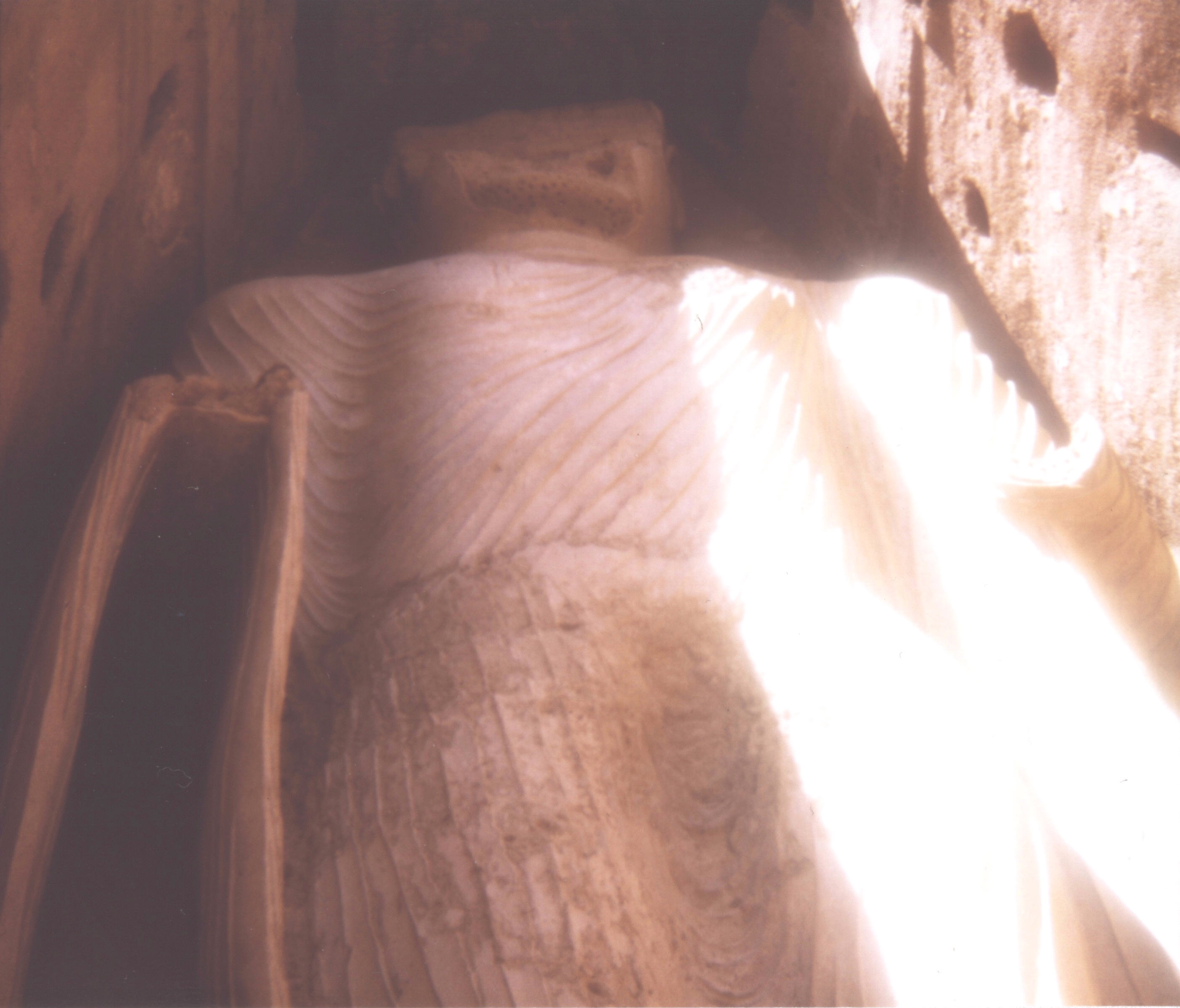
Figure 1. The western Buddha figure, 1974.

Figure 2. The western Buddha niche, 1974.

Figure 3. The eastern Buddha niche, 1974.

Figure 4. Buddha figure painted at the top of the eastern Buddha niche, 1974.

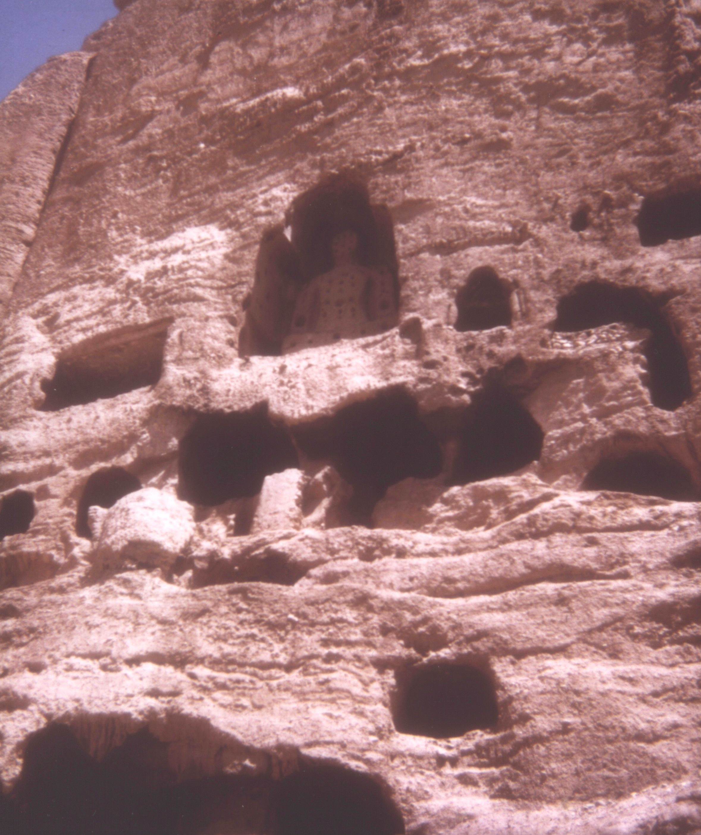
Figure 5. One of the seated Buddha niches and caves, 1974.

Figure 6. Buddha figure at Kakrak, 1974.

Figure 7. View toward Šahr-e ḡolḡola from the cliff, 1974.

Figure 8. Šahr-e ḡolḡola, 1974.

Search terms:

 بامیان bamian baamiyan baameyan


(Multiple Authors)

Originally Published: December 15, 1988

Last Updated: December 15, 1988

This article is available in print.
Vol. III, Fasc. 6, pp. 657-661