


ĀBĀDĀN
ii. The modern city
island and city in the ostān (province) of Ḵūzestān is located at the head of the Persian Gulf. At the turn of this century the alluvial island of ʿAbbādān had a few peasant hamlets and a scattering of palm groves along the coast. The city which developed after 1900 under a foreign impulse has a structure unique among Iran’s urban forms.
Economic activities. After the discovery of the Ḵūzestān oil fields, Ābādān was seen as a convenient site for a refinery. It was near the port of Moḥammerah (Ḵorramšahr) and lines of communications up the Karūn river (Ahvāz, at the head of navigation, is halfway to the fields of Masǰed-e Solaymān). The Shaṭṭ-al-ʿarab could accommodate ships of 20,000 tons capacity and allowed easy docking. The island was roomy and its soil firm enough to bear large buildings without elaborate foundation work. Moreover, the site of the future city was safe from flooding, even by the highest tides (such as those which covered much of the island in 1938). The Anglo-Persian Oil Company, which had been founded in 1909, at first bought 1 square mile of land on Ābādān from Shaikh Ḵaʿzal of Moḥammerah; later it extended the holding to 5 square miles. The refinery, fed by a pipeline, opened in 1912 with an annual capacity of 120,000 tons. This figure grew to 1 million tons in 1918, 5 million tons in 1930, 10 million in 1939, 17 million after World War II, and 21 million in 1960. Thus the Ābādān refinery grew to be the world’s largest.
Ābādān entered a second phase of development in 1960s. Previously its port had handled the shipping of refinery products, but this activity was shifted to Bandar Šahpūr. The latter port had served for the export of raw petroleum, a function which was transferred to Ḵarg island. Ābādān to some extent made up for its decreased port activities with the development of a petrochemical industry. This venture (shared between the National Iranian Oil company, with 74 percent ownership, and B. F. Goodrich Company, with 24 percent) produced polyvinyl chloride, dodecyl of benzine, and caustic soda. In 1975 the annual capacities were 60,000, 20,000, and 24,000 tons respectively. But, after fifty years of rapid growth, Ābādān now appears to have reached a state of relative economic stagnation.
Demography. Ābādān’s population growth has paralleled its economic development, being rapid when the refinery was expanding. In 1943 there were 25,000 refinery employees out of a total population of about 100,000; personnel reached a maximum of 39,000 (about one-third of the city population) in 1948. Productivity gains reduced the figure to 31,000 (out of a total of 143,000) in 1952 and to 27,000 in 1956, when the first official census placed the city’s population at 226,000. The city’s continued growth at this time, until the late 1950s, was due to natural increase and especially to immigration. Ābādān was the goal of the exodus from the rural western Zagros region and Kurdistan. Only on the central Iranian plateau did Tehran itself prove a greater attraction.
The 1966 census placed Ābādān’s population at 276,000, with only 12,000 refinery employees. During the preceding decade growth had thus been well below the rate of natural increase. Evidently the city was functioning as a center of emigration as refinery activities leveled off. The slowing of growth continued as the population reached 296,000 in 1976. By contrast, Ahvāz, the major development center in Ḵūzestān, averaged 4.8 percent annual population growth between 1966 and 1976. Ābādān, having mushroomed between 1910 and 1955, is at present in relative decline; it ranks seventh in size among the cities of Iran, whereas in 1966 it had been fifth.
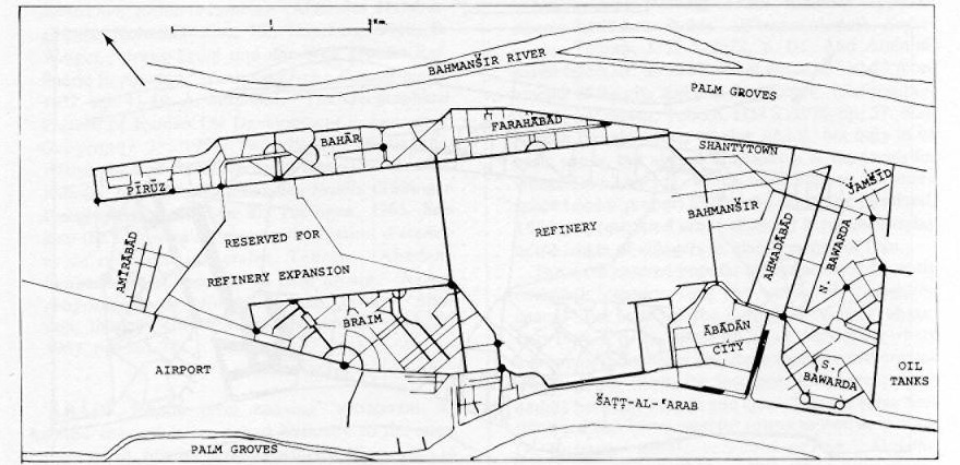
City quarters. Ābādān’s history is reflected in its juxtaposition of planned neighborhoods and spontaneously developed quarters (FIGURE 11, FIGURE 12, FIGURE 13). The refinery occupies the city’s central area and is surrounded by considerable empty space (originally reserved for its expansion but apparently now destined for other industries). The residential quarters of refinery personnel are designed on the grid plan and are of modern aspect, with asphalt streets, a household water supply, and other conveniences. The quarters differ according to the employment level and social standing of the intended population.
The workers’ housing is found in the quarters of Bahmanšīr (built ca. 1935), Farāhābād (1945), Bahār (1948), Jamšīd (1952), and Pīrūz (1958). It clusters mainly on the northeast, behind the palm groves that line the Bahmanšīr. The 70,000 residents average 150 per hectare in density. The small houses, although arrayed in rows in a western manner, are oriental in plan; an outer wall encloses a courtyard and screens family life from the street.
The quarters of the middle-level managers, to the south of the city in Bawardah, house about 8,000 people; those of the upper-level management are in Park Area and Braim, northwest of the city toward the Shaṭṭ-al-ʿarab, and accommodate about 9,000 people. These suburbs have a well-to-do European appearance, marked by villas scattered among ample greenery.
Population density varies inversely with employment level; there are 60 people per hectare in Bawardah and about 30 per hectare in Braim. In some sections of Bawardah (as also in Farāhābād and Pīrūz), transitional house plans may be noted; the residence fronts on the street, and the walled courtyard is displaced to the rear. The houses’ living area also varies with social standing, from 50 to 70 square meters in the workers’ quarters to 100 to 150 square meters in Bawardah to 150 to 190 square meters in Braim. Similarly, property sizes range from 200 to 1000 square meters. There are no commercial enterprises in the residential areas. A few groups of shops in Farāhābād and Bahār and on the southern outskirts of Braim cater to daily needs. Cultural centers (many clubs, some cinemas) are found only in the management quarters.
Around these formal neighborhoods of the Anglo-Iranian Oil Company have emerged spontaneous complexes of traditional houses. The overall grid plan to some extent controls the pattern of development, but the dwellings are juxtaposed in disorder. These areas are characterized by scanty facilities (open drainage in the street, water supply from crossroad fountains) and high density (600 to 650 people per hectare).
The quarter of the bazaar (Ābādān city) sprang up just south of the refinery and Park Area near the Shaṭṭ-al-ʿarab. There one finds small low-ceilinged shops with living space on the first floor. Their fronts line the street—a feature typical of recent commercial centers in Iranian towns. There is no clear grouping by profession, in contrast to traditional bazaars. The population is about 40,000, and the quarter contains about 1,000 business establishments and artisan workshops, approximately one-half the city’s total. To the east of the bazaar is Aḥmadābād; its 80,000 people are poor, but its housing is of permanent materials. The flat roof terraces and untidy inner courtyards recall traditional Islamic housing. The main arteries have been invaded by rows of small shops, so that Aḥmadābād accounts for much of the other half of Ābādān’s commerce (but catering mostly to daily needs or petty wants). East of Aḥmadābād and Bahmanšīr, the quarters of Kārūn, Kofīša, and Abu’l-Ḥasan (with ca. 30,000 inhabitants) present a rather degraded aspect. They are, in part, shantytowns, or are otherwise characterized by crude construction. Finally, among the palm groves lining the Bahmanšīr and Shaṭṭ-al-ʿarab north and south of the city is found a kind of rural suburb with mud-brick houses of the peasant type.
Urban organization. The city is compartmentalized and lacks true integration. A traditional Islamic Iranian town displays a strong framework and a profound unity, but, in Ābādān, relations among the quarters are kept to a minimum. The refinery’s extensive areas of empty space or of massed piping define the various sectors and channel traffic into narrow alleys. With a physical structure which accomplishes the set purpose of social segregation. Ābādān differs markedly from other Iranian cities. As an industrial islet implanted by advanced foreign capitalist enterprise to make use of an underdeveloped country’s unskilled labor and raw material, Ābādān has with reason been called a colonial town. It shows the latter’s strict hierarchy of town quarters and social divisions and the resultant psychological impact. The hierarchy is perpetuated even though the composition of the upper managerial levels has changed from entirely British and Indian in origin to largely Iranian.
Social contrasts. Strong cultural and social oppositions underlie the external divergencies described above. In 1956, illiteracy reached 49 percent in Aḥmadābād and 35 percent in the workers’ quarters but fell to less than 3 percent in Bawardah and to zero in Braim. Of skilled workers, 41 percent were illiterate; of the unskilled, 55 percent. Another point of contrast was geographical origin: Ḵūzestān, which linguistically is quite arabicized, contributed 42 percent of blue-collar workers, compared with 48 percent from Fārs and Isfahan. However, Ḵūzestānīs made up only 26 percent of white-collar workers, while natives of Fārs and Ḵūzestān constituted 43 percent. The remainder were from more distant provinces. A low 9 percent of the managers were from Ḵūzestān. The proportion of natives of Tehran, the Caspian, Azarbaijan, and Kurdistan rose from 4 percent of blue-collar workers to 22 percent of white-collar workers to 45 percent of managers. Thus, while Arabic speakers were concentrated on the lower rungs of the work force, managers tended to be brought in from some distance.
A 1959 survey indicated that these various components of the population differed greatly in aspirations, value systems, and behavior. Several fundamental differences could be distinguished: 1. At Aḥmadābād the dominant theme was dissatisfaction with housing. Social life was seen to be organized around courtyard groupings. Houses were often of only one room, and the entrance was constantly open to the public area, ensuring the free movement of children. 2. The workers tended to be satisfied with their housing. Family privacy was preserved, and the house door was kept closed. Sports clubs provided an avenue of social relations with the outside not found in Aḥmadābād. 3. The upper-level staff in Braim had a more elaborate social life with leisure clubs, dances, and games. Moviegoing and reading increased as social class rose. Religious preoccupations and political criticism, on the other hand, lost ground to technical interests and pursuit of entertainment in the upper classes. The refinery workers and the non-company population had a cultural purview limited to Iran, in contrast with the distinct acculturation toward western values among the managers. The middle-level managers modeled themselves on their superiors, particularly in the use of clubs, but also in the other behavior and attitudes. Their deep aspirations, however, were closer to the workers’, and they were ill at ease. Such people predominated in some sectors of Bawardah and Park Area.
Refinery and bazaar. The development of the oil industry thus introduced in Ābādān a sociocultural stratification unparalleled in other Iranian cities. The only factor capable of inducing some integration is the bazaar (Ābādān city). Only here can most of the population mingle, for the oil company’s original hierarchical and segregated order did not organize a distinct supply of goods and services for the different social groups. (Company shops specialized for the various classes might have met the purpose.) The company has in fact felt the need of a local point of support and of interesting people in its own prosperity by giving them some participation in it. The bazaar may be viewed as existing only because of the refinery’s activity.
But, apart from economics, the bazaar is totally opposed to the refinery. It forms a traditionalistic milieu whose value system contrasts directly with that of an industrial and colonialist society. The bazaar is a hotbed of criticism directed against this type of society, and a vigorously polemical spiritual atmosphere is developing there.
In sum, Ābādān is an exceptional laboratory for analyzing the contradictions caused by Iran’s economic development and industrialization. The present account is based on studies carried out in the 1950s. Since then the city has not changed much demographically or economically, but the effect exercised by new means of communication (particularly television) remains to be evaluated.
Bibliography:
W. Schweer, Die turkisch-persischen Erdölvorkommen (Abh. des Hamburgischen Kolonialinstitut 30), Hamburg, 1919.
E. Weight, “Irans Erdöl und der Welt grosste Raffinerie in Abadan,” Geographische Rundschau 9, 1957, pp. 41-49.
A. Melamid, “The Geographical Pattern of Iranian Oil Development,” Economic Geography 35, 1959, pp. 199-218.
I. Djazani, Wirtschaft und Bevölkerung in Khuzistan und ihr Wandel unter dem Einfluss des Erdöls (Tübinger Geographische Studien 8), Tübingen, 1963.
See also the following articles by the Institut d’études et de recherches sociales, Tehran: “Abadan: morphologie et fonction du tissu urbain,” Revue gé ographique de l’Est 4, 1964, pp. 337-85; “Abadan: tissu urbain, attitudes et valeurs,” ibid., 9, 1969, pp. 361-78.
Figure 11. The Quarters of Ābādān (Revue gé ographique de l’Est, 1964, p. 338.)
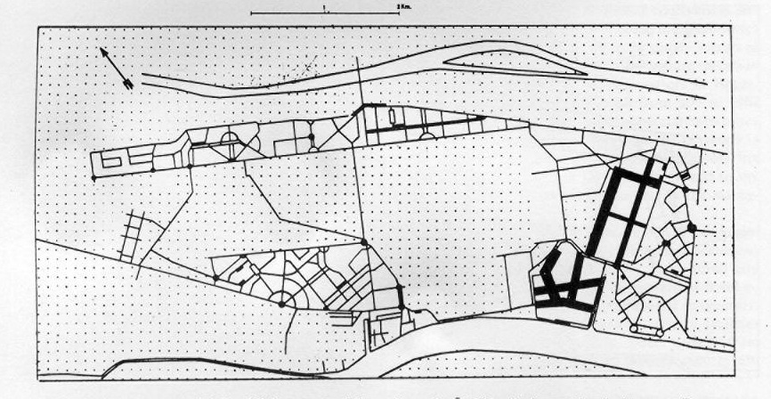
Figure 12. Residential Population of Ābādān (a dot represents 1,000 inhabitants; source: the census of 1335 Š./1956 and other documents; Revue gé ographique de l’Est, 1964, p. 346)
Figure 13. Commercial Establishments and Shop Areas in Ābādān (indicated by dark areas; Revue gé ographique de l’Est, 1964, p. 348)