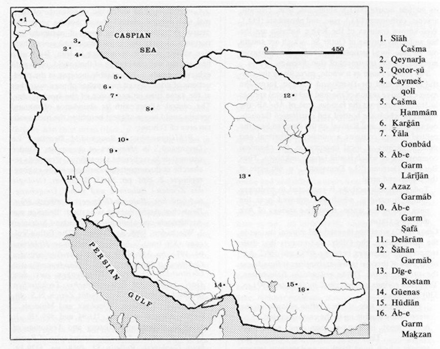


ĀB-E GARM “warm water”: hot springs and mineral springs in Iran (Figure 10).
Springs in general. Springs are defined as places on the earth’s surface where underground water fed by rainfall issues forth either continuously or periodically. Sometimes a spring may also yield juvenile water that comes from deeper regions of the earth. Springs are formed especially at the intersection of the water table and the earth’s surface. The amount of water flowing from a spring is determined by rainfall, evaporation, seepage, and the supply of underground water. Springs can be classified according to various criteria; a common distinction is based on tectonic conditions and the way the water flows: viz., between descending and ascending springs. (a) Descending springs are those whose water flows downward at the point where it emerges. They include valley springs , which occur when the valley slices down as far as the water table. Stratum springs, another common form of descending spring, occur where a level or only slightly inclining impervious stratum crops out on a slope beneath a porous stratum containing water. In the case of overflow springs, ground water collects in a porous basin above impervious strata and overflows at the edges. Those springs in Iran which flow all the year round or gush forth periodically belong to the descending type. This is especially true of the majority of the springs in the mountainous fringes of the Iranian highlands, for example, in the Alborz and Zagros mountains. (b) Ascending springs are characterized by an upward flow of water caused by hydrostatic pressure. This category includes the fissures and fault springs which are frequently found in Iran; these occur where impervious rocks have been forced against porous rocks for a fairly lengthy distance. As a result of the strong tectonic convulsion of almost all parts of Iran (see Stöcklin 1968, in bibliog.), fault springs are found in several regions.
There is a special kind of spring, the karst spring, in areas which have no consistent water table. The water usually collects in great clefts within chalky formations or flows in a subterranean channel and often includes the best-known springs in Iran, for example, those of Češme ʿAlī near Ray, Fīn (Bāḡ-e Fīn, though here admittedly in conjunction with tectonic disturbances) near Kāšān, or Ṭāq-e Bostān near Kermānšāh.
Thermal springs (general). Taking the temperature and chemical composition of the spring water as criteria, one may distinguish between normal springs, whose water shows the mean annual air temperature of their location, and those springs whose average temperature is higher than the local air temperature. A general feature of warm springs is that their water originates in deeper parts of the earth’s interior. At an average water temperature of more than 20°C to 25°C, one speaks of thermal springs; in the case of temperatures of over 50°C, of hot springs. When the boiling point is exceeded, the spring water is hurled into the air by the pressure of the steam, thus forming a geyser. From the geological and tectonic point of view, thermal springs represent the weakest residual manifestation of the differentiation and crystallization of the magma in the interior of the earth. The solidifying of molten magma—which, in its various phases (the liquid-magmatic, with temperatures of 1200°C to 600°C; pegmatic-pneumatolythic, with temperatures of 600°C to 400°C; hydrothermal, with temperatures less than 400°C) is connected with the formation of specific ore deposits—is also the key factor behind the rich mineral content of thermal waters.
Thermal waters may be categorized according to tectonic location. The following classification has been suggested: 1. Hydrothermal water, warm relative to its environment (regardless of its origin). 2. Magmatic water, from whatever depth or ultimate origin. 3. Plutonic water, which has been separated from magma at a considerable depth—on the order of several miles. 4. Volcanic water, which has been separated at or near the surface. 5. Mixed waters (for details, see in bibliog. White, “Thermal Waters,” pp. 1638-39).
A further division of thermal waters may be made according to mineral composition: Acidulous springs contain more than 1 gr of carbon dioxide to 1 kg of water. Alkaline springs contain predominantly sodium and calcium hydrocarbonate. Salt springs have more than 1 gr of sodium chloride to 1 kg of water and often contain iodine and bromine. Bitter springs are mineral waters with considerable quantities of sulfates of natrium, magnesium, and calcium. Iron springs show appreciable amounts of iron sulfates. Arsenical waters, containing 0,1 gr of arsenic to 1 kg of water, usually contain iron as well. Sulfurous waters are characterized by hydrogen sulfide in solution. Radioactive springs contain emissions of radium or traces of radioactive salts in solution. The tectonic and mineral classifications of thermal waters are complimentary and demonstrate that the origin of these warm springs is to be found in tectonic magmatic activity in the interior of the earth. Many mineral springs, on emerging at the surface, precipitate the minerals that have been carried in solution, for example, volcanic limestone, siliceous deposits (travertine), iron ocher, etc.
Thermal springs in Iran. Since detailed geological investigations in Iran have been sporadic, there is no single comprehensive study of its thermal springs. Information about them is incomplete and unsystematic; a concise history of the geological development of Iran (Harrison 1968) and the country’s mineral deposits (ibid.) says nothing about the thermal springs. In the light of the preceding general explanation of their origin and distribution, it may be assumed that thermal springs are located, above all, in the geologically youngest parts of the country, that is, in the region of tertiary mountain folds and their foothills, and along tectonic fault lines. Another sign of thermal or mineral springs must surely be the widely distributed place-name Āb-e Garm.
Only a few springs have been described, let alone analyzed. Damm (1968, in bibliog.) gives the following description of the Zendān-e Solaymān area, some 200 km southeast of Tabrīz:
The spring waters which today emerge on the Zendān plateau are warm, sulfurous, medicinal springs. In places spring gas also escapes freely…. The limestone deposit springs of the Taḵt-e Solaymān region lie in a zone with a recent volcanic history. The composition of the spring gas indicates a juvenile volcanic origin. This supposition is strengthened by the occurrence of dry exhalations near Gūgerḍčī which deposit sulfur. The spring waters must have emerged on deep fault lines under high artesian pressure, in places perhaps as fountains with a freely rising jet. Their somewhat variable yield indicates a connection with the circulation of vadose water. In 1963 and 1965, in the spring, the water level in Lake Taḵt was 18 cm higher than the August level. After heavy rain the yield from the springs increased some two days later. The springs throughout the Zendān plateau produce only a few liters and those on the Taḵt-e Solaymān roughly 100 l/sec. (In late summer.) The volume of water in Lake Taḵt and the capacity of the Zendān funnel amount to about 450,000 cu m.
The minerals contained in the water samples can easily be derived from underlying marbles (to a considerable extent the travertines seem tied to the same area of distribution) or gypsum deposits (not absolutely essential) and through the accumulation of CO2 and of H2S (in part oxidized into sulfate). Apart from a general dilution, the Taḵt water shows a disproportionate decline in alkaline ions at a more or less constant Na/K ratio. This Na/K ratio could be determined by a juvenile water constituent (from volcanic stream). The contrary relationship of HS ions and SO4 ions appears to be the result of oxidation taking place near the surface.
The water temperature of the springs on the Zendān plateau ranged in 1961 from 11°C to 39°C. The maximum temperature was reached at several points situated far apart. Two of the larger and warmer springs are used for bathing. In Lake Taḵt the water temperature is probably constant 21°C. The increased temperatures may be caused be geothermic heating, by additional warmth from volcanic processes, or by juvenile steam.
A characteristic feature of the springs of the Taḵt-e Soleymān is the large number of mineral precipitations which have led to massive formations of travertine in that region. The most frequent mineral deposits include quartz (SiO2), aluminum, iron, calcium, arsenic, carbonate (CO3), zinc, and phosphate (PO4). Well-known features of the Kūh-e Sabalān are the hot sulfurous springs of Qotūr Sū, which are sought out by the local people, especially the Šāhsavan nomads, for the treatment of skin diseases.
The Alborz range as a whole, particularly the central area around the Damāvand volcano, forms the most extensive region of thermal and mineral springs in Iran. Apart from the famous spas of Āb-ʿAlī, the waters of which are bottled and distributed throughout the country, and Rāmsar on the Caspian Sea, the central Alborz contains a number of thermal and mineral springs of local importance, the chemical composition of which is still largely unknown. Thus Bout and Derruau (“Le Demavand,” p. 68) write of the Damāvand area:
Today volcanic activity is restricted to hydrogen sulfide fumaroles, which are released near the peak and at the warm, travertine springs of Ask and Āb-e Garm.
Glaus (1965) mentions thermal and mineral springs in the Dalir Valley , Čālūs, and reports that their temperature measures between 40°C and 50°C. Another area of thermal or mineral springs is found near the summit of the Taftān volcano in Baluchistan. These hot springs are described by Gansser (1971, p. 330) as follows:
On the east side of [thermal] Taftan volcano, in the steep valley leading up thermal eastern crater[,]… occur most interesting alum and sulfur hot springs…. Thermal temperature is over 60°C and the springs which issue from an agglomerate terrace produce a concentrated alum water with its typical sour and highly stringent taste, mixed with some sulfur. Most striking are the strong colors of the crystallized salts, varying from brilliant red-orange to white. Further up towards the eastern crater a smaller hot alum and sulfur water spring exists, issuing from large andesite boulders fallen from the steep crater walls. The local nomads reported that about 12 years ago (1958?) a strong geyser-like eruption was noted in the eastern half crater, which initiated the upper hot spring, which apparently did not exist before. A certain irregularity in the production of hot water seems evident.
The distribution of thermal or mineral springs described here is of course incomplete and sporadic. One may expect to encounter intensified spring activity not only in other volcanic provinces of the country (the Bīǰār area in northwest Iran, large parts of Azarbaijan, small areas southwest of a line from Kermān to Yazd), but also along tectonic fault lines in central Iran. Near Neyband in central Iran, on the road from Ṭabas to Kermān, there are numerous springs, some of them warm, around which oasis settlements have grown up; warm sulfurous springs can also be found near Nūrābād/Fahlīān, west of Shiraz in consequence of more recent tectonic movements of the Zagros range.
Conclusions. The economic significance of thermal and mineral springs should not be underestimated. It would therefore seem of particular importance to carry out a systematic and comprehensive survey of their occurrence in Iran. By boring new springs and making use of their yield, one could achieve not only a considerable increase in the production of drinks based on supplies of pure water but at the same time an expansion of the spa industry. The central Alborz with its abundance of mineral springs could prove of great benefit to the metropolitan area of Tehran.
Bibliography
P. Bout and M. Derruau, “Le Demavand,” in Mémoires et documents, Centre national de la recherche scientifique, Centre de recherche et documentation cartographique et géographique, 8, 1961, pp. 39-83.
B. Damm, Geologie des Zendan-i Sulaiman und seiner Umgebung, süd-östliches Balqash-Gebirge, Nordwest-Iran, Deutsches Archäologisches Institut: Beiträge zur Archäologie und Geologie des Zendan-i Sulaiman 1, Wiesbaden, 1968.
A. Gansser, “The Taftan Volcano (SE Iran),” Eclogae geologicae Helvetiae 64, 1971, pp. 319-34.
M. Glaus, Die Geologie des Gebietes nördlich des Kandevan-Passes (Zentral-Elburz), Iran, Mitteilungen aus dem Geol. Institut der Eidgenössischer Technischen Hochschule und der Universität Zürich N.S. 48, 1965.
J. V. Harrison, “Geology and Minerals,” Camb. Hist. Iran I, pp. 111-94 and 489-516.
J. Stöcklin, “Structural History and Tectonics of Iran: A Review,” American Association of Petroleum Geologists Bulletin 52, 1968, pp. 1229-58.
D. E. White, “Thermal Waters of Volcanic Origin,” Bulletin of the Geological Society of America 68, 1957, pp. 1637-58.