


SOGDIANA
ii. Historical Geography
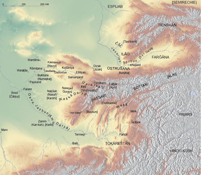
For physical geography, see CENTRAL ASIA i; for the cities or regions within Sogdiana, see relevant articles (e.g., Bukhara, Samarqand, Keš, Košāniya, Panjikant, etc.); for maps, see Figure 1; de la Vaissière, esp. map 5; and Bregel, esp. p. 25.
The earliest records of the name of Sogdiana (Soḡd) are found in the Avesta (Vendīdād, 1.4; Yašt 10.14; the by-name of Sogdian lands in the Avesta is Gauua-, which probably survives in He prefecture in Chinese sources [see below; Tremblay] and modern Ḡusar, lit. “head of Gauua” on the eastern edge of the flatland part of Zeravshan, see Steblin-Kamenski), whose date of composition remains disputable, and in Achaemenid inscriptions (as Suguda or Sugd; DB1.16; XPh 21) of the 6th century BCE onwards as well as the Greek records of Herodotus (Sugdianē; largely following Hecateus) and Ctesias. However, they only mention it as a country, along the same lines as Bactria and the Saka tribes, Margiana, Chorasmia, Areia/Aria, etc. It is clear that Sogdiana was located in the northeast of Iran, but it is only possible to deduce further details from the later texts. It is not clear whether Sogdiana ever formed a separate satrapy; at the time of Alexander’s invasion, it seemed to represent a part of the Bactrian satrapy (see Bernard, p. 26; Briant, pp. 743-54). The name Sogdianus, probably related to Sogdiana in some way, appears as name of an Achaemenid king for a day in 423 BCE (see Schmitt, p. 272-76). The fortifications of the towns Naḵšab and Keš as well as probably the localities Amainakāna (Mink) and perhaps Kum in the Hissar range in northwest Tajikistan are mentioned in the recently discovered Aramaic documents from Afghanistan, dating back to the late Achaemenid and early Macedonian time (see Shaked, pp. 1528-30).
Alexander the Great spent the years 330-327 BCE capturing Transoxian lands. The position of many towns mentioned by historians of Alexander (Arrian, Curtius) and minor texts (Metz Epitome gives many additional details about these events) can be established on the basis of linguistic, geographical, and archeological considerations. Thus Maracandais identified with Samarqand (Arrian, 3.30 ff.; Curtius, 7.610 ff.); Gazaca with modern Ghazandarak (medieval Ḡazaq; Eṣtaḵri, p. 344; Ebn Ḥawqal, p. 503; Moqaddasi, pp. 49, 265); Cyra Eschata (Cyropolis)with medieval and modern Kurkat, both located to the southwest of Khujand (Ḵojand) on the Syr Darya (Tanais, Jaxartes), which is commonly taken to correspond to Alexandria Eschata; and Xenippa with medieval Naḵšab (with metathesis, see Sims-Williams, apud Grenet, p. 210, n. 40), modern Qarši. The position of the “Rocks” of the Sogdian insurgents probably corresponds to the high natural plateau near the Baysun pass. The exact routes taken by Alexander, his companions, and his enemies, however, remains to a certain extent controversial (see Grenet and Rapin; Rtveladze, Rapin, 2004; P’iankov, 2004; Rapin et al.). Alexander’s historians (e.g., Arrian, 6, 16) and Eratosthenes (quoted by Strabo, 11.8.8) inform us that Sogdiana borders Bactria on the Oxus River (Āmu Daryā, q.v., probably with the Waḵš as its upper course, otherwise only the middle course of the Āmu Daryā between Kerki [Atamyrat] and Čārjuy [formerly Āmol, now Türkmenabat], towns in present-day Turkmenistan, was intended) and Scythian tribes on the Jaxartes.
In Ptolemy’s geography (2th century CE), the picture appears to be very complicated due to the amalgamation of earlier traditions and almost contemporary observations. On the one hand, we learn a number of identifiable place-names (Cholbēsena with Holbok, not far from present day Kulāb, 6.12.5; Phratrua with Farabr opposite Āmol, 6.11.9; Astacana with Eštiḵan to the west of Samarqand, Ptol., Geog., 6.12.5, 6.11.9, 6.11.8) and river names (Dargomanēs with the Dargam near Samarqand; Baskatis with the Pskem in the Tashkent oasis; Ptol., Geog., 6.11.2, 4; 6.12.3); but, on the other hand, the position of many places is distorted (e.g., Maracanda/Samarqand is located in Bactria, and Alexandria Eschata is separated from the Jaxartes; Ptol. Geog., 6.11.9, 6.12.6; for various attempts to explain the origins of these confusions, see P’iankov, 1997; idem, 2004; Rapin). Some additional information can be gathered from other geographical texts and maps of classical tradition, especially those of Pliny the Elder, Pomponius Mela, anonymous Tabula Peutingera (where Antiochia Tarmata, i.e., Termeḏ, is shown), and the Ravenna anonymous (see also Tomaschek, Kretschmer, Markwart, 1946).
The Chinese sources mention Sogdiana for the first time as the land sending its tribute around 116 BCE (Shiji), but the form given there as well as in Hou Hanshu and a record on an embassy from Kangjiu and other Central Asian lands, which was recently discovered in the vicinity of Dunhuang (see Wang), is ambiguous (Suxie, 蘇䪥 reconstructed as *saẖ-gleats for Han-time pronunciation, see Hulsewé and Loewe, p. 130, n. 320; old pronunciations are based on Karlgren). In Hou Hanshu (the description can be dated to 125 CE), *Su-yi (Old Chinese si̯uk-di̯uk) is mentioned as a subordinate kingdom of Kangjiu; in Weishu and Beishi (events of 4th-6th centuries), Suishu (589-618), and particularly in Tangshu and related texts (especially the memoirs of Xuanzang), the Sogdian lands are described in much detail (see Chavannes, pp. 132-47; Shiratori, passim; Miller, pp. 12-13; Maliavkin, pp. 64, 221-24; Stark, passim, for commented translations of relevant chapters). The Chinese perceived Sogdiana not as a unitary state but rather as a federation of cantons of “hu” (胡) barbarians (i.e., a settled Iranian population), which were governed by princes of the Zhaowu (昭武, Sogdian Čmwk-; see Yoshida, 2003) clan. The most important ruler resided in Samarqand, which was named Kang (康) and considered to be a continuation of the ancient Kangjiu state. Other lands of the “hu of nine houses of Zhaowu” (the contents of “nine” here is not explained, but cf. “Soḡd of Seven Nests” in the Middle-Persian tradition, on which see Kia; cf. also Yoshida, in EIr online ed.) were also given one-syllable names: so Māymorḡ (to the east of Samarqand, including Panjikant?) was called Mi (米); Osrušana (the region of Ura-tyube), the northern part of Samarqand oasis and its northwestern part around Eštikan were called Cao (曺, eastern, central and western respectively); further west, around Karminiya and modern Navoi, on the middle Zarafšān, He (何) was located; the Bukhara oasis was called An (安, after ancient Anxi [the transcription of Aršak], “Parthia”), and the upper part of the Bukhara oasis was the “Minor An”; Paykand was Bi (畢, pjit); Keš on the Kaška Daryā was Shi (史) and Naḵšab below Keš was called Minor Shi or Nasebo (那色波). These one-syllable denominations were also applied by the imperial administration as surnames of Sogdians (“hu”), who lived in China and are attested even in Sogdian texts composed in the Far East (x’n for Kang and ’’n for An; see Henning, 1948, p. 603 n. 2; Yoshida, Rev. DTS, pp. 366-67). The territories adjoining Sogdiana, namely Shi (石, Čāč, Tashkent oasis),Mu or Wu-di (穆; 戊地 muwk, məwh-dih, Āmol, modern Čārjuy [Türkmenabat] on the Āmu Daryā), Wu-na-he (烏那曷 ʾō-nah-γat, probably *Wana-γar, a Sogdian mis-translation of Parthian Kar-kōh, modern Kerki on the Āmu Daryā, see Lurje, forthcoming), Huoxin (火尋, xwaʾ-zim,Chorasmia) were also sometimes included in the Zhaowu confederation according to the Chinese histories. In the travel-report of Xuanzang, who passed through Central Asia in 630, all the territory between Suye (素葉, Suyāb in the Ču valley, to the East of modern Bishkek in Kyrgyzstan) and the “Iron Gates” mountain pass between Keš and Termez is called Suli, and it is said to have one and the same language and culture. The Chinese records of this time supply us also with transcriptions of a number of local place-names (mostly identifiable ones), reliable accounts on distances between cities, descriptions of rivers, mountains, remarks on the economy, religions of Sogdian lands and their political organization (including the names of a number of rulers and their embassies to the imperial court). The “houses of Zhaowu,” that is, minor principalities of Sogdiana, had a certain degree of independence; some of them at least had their own coinage.
Although Sogdian compositions dedicated to geography known so far are limited to two fragments of a “list of nations” (ed. Henning, 1940, pp. 8-11, of 23 words; Kudara, Sundermann, and Yoshida, p. 143, which is even worse preserved), a certain number of place-names can be extracted from surviving texts; they are, however, most commonly represented in the form of ethnic adjectives that were used as a kind of surname (the largest amount of such names is found among the Upper Indus inscriptions; see Sims-Williams, 1992); a number of place-names is attested in the Mt. Mugh documents, where the toponymy of the upper part of the Zarafšān valley is represented particularly well (see Smirnova, 1960). The recently discovered fragments of archaic Sogdian inscriptions at Kultobe in the Southern Kazakhstan (3rd cent. CE at the latest) mention the rulers (mrʾy) of Samarqand, Keš, Naḵšab, Bukhara (called Nawak-mēṯān) and the army-leader of the people of Čāč (Tashkent); they probably indicate the confederative organization of Sogdiana already at this early stage (see Sims-Williams and Grenet). Certain information on Transoxiana can be gleaned from Pahlavi texts (see Markwart, 1938, pp. 137-64; Daryaee, with literature).
The most detailed description of Sogdian lands are found in the Arabic and Persian geographical texts of pre-Mongol times (on which see Barthold, 1968, and Bolshakov for urban settlements). The geographical treatises of Ebn Ḵordāḏbeh, Qodāma, Yaʿqubi, Moqaddasi, Ebn Ḥawqal, Eṣṭaḵri, the anonymous Persian geography Ḥodud al-ʿālam, as well as the geographical and biographical dictionaries of Samʿāni and Yāqut, the local histories by Naršaḵi and Nasafi, and many other texts, provide us with several hundreds of geographical names from the basins of the Zarafšān and Kaška Daryā, mostly Sogdian in origin. According to these texts, the Zarafšān, which was called the river of Ṣoḡd, originated in the mountains of middle Bottam (i.e., the Pamir-Alai massive) in the territory of Borḡar (pre-modern Falḡar, today Ayni), and having passed through the lake J̌ey or Daryāža (Iskander-Kul?), entered the region of Samarqand, which consisted of twelve districts: Bonjikaṯ (Panjikant), Waraḡsar (“head of the dam,” where the canals of the Samarqand oasis separated), Māymorḡ (around modern Urgut), Sanjarfaḡān, Darḡam (along the Dargam canal), and Abḡar (around modern Juma) were located to the south of the river, while Yārkaṯ, Burnamaḏ (in the direction of Osrušana), Bozmājan, Kabōḏanjkaṯ, Waḏār, and Marzbān were to the north (Eṣṭaḵri, p. 319 ff; Moqaddasi, p. 266; Ebn Hawqal, p. 498).
Downstream, the districts Eštiḵan and Kušāniya were located, further on the towns Dabusiya and Karminiya (around modern Navoiy, already reckoned within the Bukhara oasis); the next station, Ṭawāwis (Peacocks [city], the older name being Arqud), was inside the rampart, which was surrounding the Bukharan oasis and is known today as Kampir-duwol; fifteen districts of Bukhara were located within it and seven districts outside. Among the most important places in Bukhara oasis one can mention Rāmiṯana, Chinese Alanmi, its pre-Islamic capital; Wardāna, which was once governed by a separate ruler, the Wardān-ḵodāt, both located in the northern part of the oasis; Waraḵša to the west, a countryside residence of Boḵār-ḵodāt (Naršaḵi, p. 24), where the famous artistic remains were found; and the merchant city of Paykand to the southwest, outside the wall, which enjoyed a certain extent of autonomy. The capital of the oasis was more precisely called Numejkaṯ, and Naršaḵi informs us that it was a newer foundation than some other towns and villages of the oasis (Naršaḵi tr. Frye pp. 16, 17); noteworthy is that the Sogdian pwxʾr (as well as Bactrian bôxaro) functions as an adjective from which *pwxʾrʾkh / Boḵārā seems to be a derived noun.
The Kaška Daryā valley (now Qashqadaryo; for the most up-to-date description, see Kamaliddinov) was divided into two regions: Keš (today Shahrisabz) on its upper course and Nasaf (Naḵšab, modern Qarši) below. The former had sixteen districts (not easily identifiable); most prominent are Ḵozār, modern Gozar to the south, mountainous Siām to the east, and the Iron Gates (Dar-e Āhanin), which led towards Termeḏ, around modern Darband. In the district of Nasaf, the large villages were Kasba, which led towards Bukhara, and Basda on the road to Kar-kuh (Kerki); Nowqad Qorayš (new town of the Qorayš tribe) was located half-way between Keš and Nasaf.
In the above mentioned texts of Islamic times we can observe the shrinking of the concept of Soghdiana. The Transoxian regions of Farḡāna, Ḵvārazm (Chorasmia) and the lands on the Oxus confluents,Čāč and Ilāq (modern Tashkent oasis), or even Osrušana (Ostrušana around Ura-tyube and Jizak) are never considered part of Sogdiana by Islamic authors. It is only the somewhat misleading passage of Yaʿqubi which includes Keš and Nasaf in Ṣoḡd (p. 293; but cf. Ebn Ḥawqal, pp. 474-75; Eṣṭaḵri, pp. 286-88, 316); the opinion that Bukhara is part of Sogdiana is mentioned by Ebn Ḥawqal (p. 492) and Eṣṭaḵri (p. 316) and indirectly implied by Biruni (pp. 220 ff., cf. Barthold[-Bosworth], p. 773), while this opinion is severely criticized by Moqaddasi (p. 269, cf. Smirnova, 1963,p. 23). Yāqut (III, p. 394) mentions the existence of two Sogdianas, one that of Samarqand and another that of Bukhara, quoting a certain Ḥāzemi (probably the confident of the Samanid vizier Balʿami; see Samʿāni, IV, p. 1047). The majority of the early Islamic authors, including those named above, equate Soḡd with Samarqand oasis and the middle Zarafšān valley. However, Samʿāni, the author of Ḥodud al-ālam (ed. Sotuda, p. 43, tr., Minorsky, p. 63), on one occasion Nasafi (p. 438), and sometimes Moqaddasi (pp. 269, 279-80) use the word Ṣoḡd only for the middle course of the Zarafšān between the Samarqand and Bukhara oases, that is, the area of Karminiya, Dabusiya, Rabenjan, and Košāniya with Eštiḵan as its center. Subsequently, the sources of Timurid times mention only Soḡod-e Kalān(Greater Soḡod) and Soḡod-e Ḵordor Nim-soḡod (Minor Soḡod, or Semi-soḡod) as two cantons, one to the north of Miyankal, and another on this island (Waqf-nāmas [acts for pious foundations] of Ḵˇāja Aḥrār and his heirs of 1470, 1480, 1482, 1489, in Chekhovich, ed., as doc. 5, 7, 8, 10; Samariya, p. 56). Later on, Soḡod-e Ḵord was renamed Āfarinkent, while Soḡod-e Kalān (called Sugut) was still in use in early colonial times (Vyatkin, p. 57-69).
The name of Sogdiana appears in several minor place-names of recent time (like Soḡd near Wobkent to the north of Bukhara, the birthplace of the historian Aḥmad Dāneš (Doneš), Soḡduin Yaghnob (see Klimchitsky; Livshits, p. 80;). In 2000, the Khujandor Leninobod (Leninābād) province of Tajikistan was renamed Soḡd province (Viloyati Suḡd), which is of course an artificial denomination.
Several locations in medieval Eurasia bear names similar to Sogdiana and were probably founded as Sogdian colonies. The most famous, although contradictory, one is Sogdaia, modern Sudak in the Crimea, another Soḡdabil in Georgia (see La Vaissière, pp. 241 ff). Soḡd, under the rule of a certain Bekteginin the 12th century Persian history Mojmal al-tawārik wa’l-qeṣaṣ (p. 323), corresponds to five villages of Sogdians that belong to Bektegin and are located in the cold mountains of Toḡozḡoz country (i.e., in the eastern part of Tienshan) according to the Ḥodud al-ʿālam (ed. Sotuda, p. 77, tr. Minorsky, p. 95 and comm., p. 274); Sγwδyk-stn(lit. “land, place of Sogdians”) in the Sogdian version of an epitaph of 579 CE of Wirkak found in Xian (line 7; ed. Yoshida, 2005) can mean either Sogdiana itself or a Sogdian colony in the Chinese city of Guzang or Xian. Certain Suģuta Viṃňsa is mentioned in Doc. 82 from Niya (southern rim of Tarim basin), dated to the first quarter of 4th century, probably means “Sogdian village” (Boyer et al, p. 31); the place-name Bonosogoligo in Bactria in the document S of probably 703 A.D. (Sims-Williams, 2000, I, pp. 94-95) probably means “Sogdian estate” (noteworthy is that Farnagad, native of that place, has a Sogdian rather than Bactrian name).
Bibliography
.
Arrian, Anabasis, tr. Aubrey de Sélincourt as The Campaigns of Alexander, New York, 1958.
W. Barthold, Turkestan down to the Mongol Invasion, 3rd ed., ed. Clifford E. Bosworth London, 1968.
W. Barthold-[C.E. Bosworth], “Al-Ṣughd,” in EI2IX, pp. 772-73.
Paul Bernard, “Alexandre et l’Asie Centrale: reflexions à propos d’un ouvrage de F. L. Holt,” Studia Iranica 19/1, 1990, pp. 21-38.
Abu Rayḥān Biruni, Āṯār al-bāqia ʿan al-qorun al-ḵālia, tr. Edward Sachau as The Chronology of Ancient Nations, London, 1879.
O. G. Bolshakov, “Gorod v konce VIII – nachale XIII v.,” in Aleksandre M. Belenickiĭ, Ilona B. Bentovich, and Oleg G. Bolshakov, eds., Srednevekovyĭ gorod Sredneĭ Azii, Leningrad, 1973.
Auguste M. Boyer, Edward J. Rapson, and Emile Senart, eds., Kharoṣṭhī Inscriptions Discovered by Sir Aurel Stein in Chinese Turkestan, Part 1, Oxford, 1920.
Yuri Bregel, An Historical Atlas of Central Asia, Leiden and Boston, 2003.
Pierre Briant, Histoire de l’Empire perse: de Cyrus à Alexandre, tr. Peter T. Daniels as From Cyrus to Alexander: A History of the Persian Empire, Winona Lake, Indiana, 2002.
Eduard Chavannes, Documents sur les Tou-Kiue (Turks) occidentaux: Recuellis et commentés, suivi de notes additionnelles, St.-Petersbourg, 1903, repr. Paris, 1973.
Olga D. Chekhovich, Samarkandskie dokumenty XV-XVI vv, Moscow, 1974.
Quintus Curtius, Historiae Alexandri Magni, ed. as History of Alexander, with tr. by John Carew Rolfe, 2 vols., Loeb Classical Library 368, Cambridge, Mass., 1946, repr. 1971-76.
Touraj Daryaee, ed., Šahrestānīhā ī Ērnānšahr: A Middle Persian Text on Late Antique Geography, Epic and History, Costa Mesa, Calif., 2002.
Ebn Ḥawqal, Ketāb ṣurat al-ʿarż, ed. J. H. Kramers, Leiden, 1938.
Ebn Ḵordāḏbeh, Ketāb al-masālek wa’l-mamālek, ed. M. J. de Goeje, Leiden, 1889.
R. E. Emmerick, “Sūlīya,” in R. E. Emmerick and P. O. Skærvø, eds., Studies in the Vocabulary of Khotanese II, Vienna, 1987, pp. 148-49.
K. Enoki, “Sogdiana and the Hsiung-nu,” Central Asiatic Journal 1, 1955, pp. 43-62.
Eṣṭaḵri, Ketāb masālek al-mamālek, ed. M. J. de Goeje, Leiden, 1870.
Robert Gauthiot, “Rev. Vilhelm Thomsen. Ein Blatt in türkischer ‘Runen’ schrift aus Turfan,” JA, 2nd ser. 15, 1910, pp. 538-44.
Ilya Gershevitch, A Grammar of Manichaen Sogdian, Oxford, 1954.
Frantz Grenet, “Zoroastre au Badakhshān,” Studia Iranica 31/2, 2002, pp. 193-214.
Franz Grenet and Claude Rapin, “Alexander, Aï Khanum, Termez: Remarks on the Spring Campaign of 328,” Bulletin of the Asia Institute 12, 1998 [2001], pp. 79-89.
Walter B. Henning, “Neue Materialen zur Geschichte des Manichäismus,” ZDMG, 1936, pp. 1-18 (repr. in idem, Selected Papers I, pp. 379-96).
Idem, Sogdica, London, 1940 (repr. in idem, Selected Papers II, pp. 1-67).
Idem, “The Date of the Sogdian Ancient Letters,” BSO(A)S 12, 1948, pp. 601-15 (repr. in idem, Selected Papers II, pp. 315-29).
Idem, Selected Papers, 2 vols., Acta Iranica 14-15, Tehran and Leiden, 1977.
Ḥodud al-ʿālam, tr. V. Minorsky as Ḥudūd al-ʿĀlam, “The Regions of the World,” a Persian Geography, London, 1937.
Anthony F. P. Hulsewé and Michael A. N. Loewe, China in Central Asia, The Early Stage: 125 B.C.-A.D. 23, Leiden, 1979.
Shamsiddin S. Kamaliddinov, Istoricheskaia geografiia iuzhnogo Sogda i Toxaristana po arabojazychnym istochnikam IX – nachala XIII vv, Tashkent, 1996.
Bernhard Karlgren, Grammata Serica Recensa, Stockholm, 1957.
B. Kh. Karmysheva, “Étnicheskie i territorial’nye gruppy naseleniia severo-vostochoiĭ chasti Kashka-dar’inskoĭ oblasti Uzbekskoi SSR,” Kratkie soobshcheniia instituta étnografii 33, 1960, pp. 47-59.
Maḥmud Kāšḡari, Diwān luḡat al-turk, ed. and tr. R. Dankoff as The Compendium of the Turkic Dialects, 3 vols., Cambridge, Mass., 1982-85.
A. L. Khromov, “K istorii tolkovaniia toponima Sugd,” in E. Begmatov et al., eds., Onomastika Uzbekistana, Tashkent, 1989, pp. 88-89.
Sadeq Kia, “Soġd-e haft āšiān,” in Monumentum H. S. Nyberg I, Acta Iranica 4, Tehran, Leiden, and Liège, 1975,pp. 471-73.
Iwami Kiyohira, “Turks and Sogdians in China during the T’ang Period, in T. Moriyasu, ed., Japanese Studies in the History of Pre-Islamic Central Asia, Acta Asiatica 94, Tokyo, 2008, pp. 41-65.
S. I. Klimchitsky, “Nazvanie Sogdiany v toponimike Tadzhikistana,” Zapiski instituta vostokovedeniya AN SSSR 6, Leningrad, 1937, pp. 9-13.
K. Kretschmer,“Sogdiana,” in Greg Wissowa, Wilhelm Kroll, and Karl Mittelhaus, eds., Paulys Real-Encyclopädie der classischen altertumswissenschaft, Munich, 1903-80, IIIA I, cols. 788-91.
Kōgi Kudara, Werner Sundermann, and Yutaka Yoshida, Iranian Fragments from the Ôtani Collection, Kyoto, 1997 (in Japanese).
Hiroshi Kumamoto, “Khotanese Official Documents in the Tenth Century A.D.,” Ph.D. diss., University of Pennsylvania, 1982.
V. A. Livshits (Livšic), “Sogdiĭskie dokumenty iz zamka Chil’khudzhra,” Scripta Gregoriana, sbornik v chest’ semidesjatiletiya akademika G.M. Bongard-Levina, Moscow, 2003, pp. 77-88.
Idem, “The Sogdian Wall-Inscriptions on the Site of Afrasiab,” in Matteo Compareti and Étienne de la Vaissiére, eds., Royal Naurūz in Samarkand: Proceedings of the Conference Held in Venice on the Pre-Islamic Paintings at Afrasiab, Pisa and Rome, 2006, p. 59-74.
Pavel B. Lurje, “Shapur’s Will in Bukhara,” in Matteo Compareti, Paola Raffetta, and Gianroberto Scarcia, eds., Ērān ud Anērān: Studies Presented to Boris Ilich Marshak on the Occasion of His 70th Birthday, Venice, 2006, pp. 407-18.
Idem, “Cisoxian Cantons of Sogdiana,” in V. Sadovski, ed., Gedenkschrift Xavier Tremblay, forthcoming.
Anatoly G. Maliavkin, Tanskie khroniki o gosudarstvakh Central’noĭ Azii: teksti i issledovaniya, Novosibirsk, 1989.
Josef Markwart, Wehrot und Arang: Untersuchungen zur mythischen und geschichtlichen Landeskunde von Ostiran, Leiden, 1938.
Idem, “Die Sogdiana des Ptolemaios. Heraugegeben von G. Messina,” Orientalia, N.S., 15, Fasc. 1/2, 1946, pp. 123-49 (no. 121-40); Fasc. 3, 1946, pp. 286-323 (141-56).
[Metz Epitome] Incerti auctoris epitoma rerum gestarum Alexandri Magni cum libro de morte testamentoque Alexandri, ed. Peter H. Thomas, Leipzig, 1966.
Roy Andrew Miller, Accounts of Western Nations in the History of the Northern Chou Dynasty, Berkeley and Los Angeles, 1959.
Mojmal al-tawāriḵ wa’l-qeṣaṣ, ed. Sayf-al-Din Najmābādi and Siegfried Weber, Am Neckardamm, 2000.
Abu ʿAbd-Allāh Moḥammad Moqaddasi [Maqdesi], Aḥsan al-taqāsim fi maʿrefat al-aqālim. ed. M. J. de Goeje, Leiden, 1877.
Abu Bakr Moḥammad b. Jaʿfar Naršaḵi, Tāriḵ-e Boḵārā, ed. Moḥammad-Taqi Modarres Rażawi, 2nd ed., Tehran, 1972; tr. Richard N. Frye as The History of Bukhara, Cambridge, Mass, 1954.
Najm-al-Din ʿOmar Nasafi, al-Qand fi ḏekr ʿolamāʾ Samarqand, ed. Yusof Hādi, Tehran, 1999.
I. M. Oranskiĭ, “O terminakh ‘vilayat,’ ‘vilayati’ v Sredneĭ Azii sopredel’nyx stranax,” in Pis’mennye pamiatniki Vostoka, istoriko-filogicheskie issledovaniia 1973, Moscow, 1979, pp. 151-55.
Igor V. P’iankov, Sredniaia Aziia v antichnoĭ geograficheskoĭ tradicii: istochnikovedcheskiĭ analiz, Moskow, 1997.
Idem, “Antichnye istochniki o Sredneĭ Azii i ix interpretaciia (po povodu dvux rabot F. Grene i K. Rapena,” Vestnik drevneĭ istorii 248/1, 2004, pp. 96-110.
Ptolemy, Geographia, part ed. and tr. Helmut Humbach and Susanne Ziegler as Ptolemy Geography, Book 6: Middle East, Central and North Asia, China, Wiesbaden, 1998.
Edwin G. Pulleyblank, “A Sogdian Colony in Inner Mongolia,” T’oung Pao 41, 1952, pp. 317-56.
Abu’l-Faraj Qodāma b. Jaʿfar, Ketāb al-ḵarāj, in Bibliothecae geographorum Arabicorum VI, ed. M. J. de Goeje, Leiden, 1889, pp. 184-266.
Claude Rapin, “L’Afghanistan et l’Asie centrale dans la géographie mythique des historiens d’Alexandre et dans la toponymie des géographes gréco-romains: Notes sur la route d’Herat à Begram,” in Osmund Bopearachchi and Marie-Françoise Boussac, eds., Afghanistan: Ancien carrefour entre l’Est et l’Ouest, Bruxelles, 2004, pp. 143-72.
Claude Rapin et al., “Les recherches sur la region des Portes de Fer de Sogdiane: bref état des questions en 2005,” Istoriya material’noĭ kul’tury Uzbekistana, no. 35, 2006, pp. 91-112.
Italo Ronca, Ostiran und Zentralasien bei Ptolemaios (Geographie 6, 9-21), Rome, 1968.
Edvard V. Rtveladze, Aleksandr Makedonskiĭ v Baktrii i Sogdiane, Tashkent, 2002.
Abu Saʿd ʿAbd-al-Karim Samʿāni, Ketāb al-ansāb, ed. Shaikh ʿAbd-al-Raḥmān Moʿallem Yamāni, 13 vols., Hyderabad, India, 1952-82.
Samariya, Samariya: Abu Ṭāḥer Ḵwāja Samariya, ed. Nikolaĭ Veselovskiĭ. St.-Petersburg, 1902.
Rüdiger Schmitt, Iranische Anthroponyme in den erhaltenen Resten von Ktesias’ Werk (Iranica Graeca Vetustiora. III), Vienna, 2006.
Shaul Shaked, “De Khulmi a Nikhšapaya: Les données des nouveaux documents araméens de Bactres sur la toponymie de la région (IVe siècle av. n. è.),” Académie des inscriptions et belles-lettres, comptes rendus des séances de l’anneé 2003, fasc. IV, Paris, 2003, pp. 1517-35.
Kurakichi Shiratori, “A Study on Su-tʿê or Sogdiana,” Memoirs of the Research Department of the Toyo Bunko (the Oriental Library), no. 2, 1928, pp. 81-145.
Nicholas Sims-Williams, Sogdian and Other Iranian Inscriptions of the Upper Indus II, Corpus Inscriptionum Iranicarum, pt. 2, Inscriptions of the Seleucid and Parthian Periods and of Eastern Iran and Central Asia III, Sogdian, London, 1992.
Idem, Bactrian Documents from Northern Afghanistan I: Legal and Economic Documents, Studies in the Khalili Collection, III, Corpus inscriptionum Iranicarum VI, pt. 2, Oxford, 2000.
Nicholas Sims-Williams and Franz Grenet, “The Sogdian Inscriptions of Kultobe,” Shygys 1, 2006,pp. 95-108.
Nicholas Sims-Williams and James Hamilton, Documents turco-sogdiens du IXe-Xe siècle de Touen-houang, Corpus Inscriptionum Iranicarum III, pt. 2, London, 1990” (reviewed in Yoshida, 1993).
Olga I. Smirnova, Karta verkhoviĭ Zeravshana po mugskim dokumentam (XXV mezhdunarodnyĭ kongress vostokovedov: Doklady sovetskoĭ delegacii),Moscow 1960.
Idem, Katalog monet s gorodishcha Pendzhikent, Moskow, 1963.
Sören Stark, tr. with commentary, Transoxanien nach dem Tang Huiyao des Wang Pu,Norderstedt, 2009.
I. M. Steblin-Kamenskiĭ, “Tri zeravshanskikh slova,” in R. R. Rakhimova, ed., Rakhmat-name: Sbornik v chest' 70-letiia, St.-Petersburg, 2008, pp. 338-47.
Oswald Szemerényi, Four Old Iranian Ethnic Names: Scythian – Skudra –Sogdian – Saka, Vienna, 1980.
Wilhelm Tomaschek, “Centralasiatische Studien I:Sogdiana,”SPAW, Phil.-hist. 87/1, 1877, pp. 67-184.
Xavier Trembley, “La toponymie de la Sogdiane et le traitment de *xθ et *fθ en iranien: Essais de grammarie comparée des langues iraniennes VII,” Studia Iranica 33, 2004, pp. 113-49.
Étienne de la Vaissière, Histoire des merchands sogdiens, tr. James Ward, as Sogdian Traders: A History, Leiden and Boston, 2005.
Vasiliĭ L. Vyatkin, “Materialy k istoricheskoĭ geografii Samarkandskago vilaĭeta,” Spravochnaya knizhka samarkandskoĭ oblasti 7, 1902, pp. 1-83.
Wang Su, “On the Documents of Kangju in the Inscribed Slips from Xuanquan,” in Rong Xinjiang and Li Xiaocong, eds., History of Relationship between China and Foreign Countries: New Sources and New Problems, Beijing, 2004, p. 149-61.
Aḥmad Abi Yaʿqub Yaʿqubi, Ketāb al-boldān, ed. M. J. de Goeje, Leiden, 1892, pp. 232-360.
Šehāb-al-Din Abu ʿAbd-Allāh Yāqut, Moʿjam al-boldān, ed. F. Wüstenfeld, 6 vols., Leipzig, 1866-73.
Yutaka Yoshida, “Nicholas Sims-Williams and James Hamilton, Documents turco-sogdiens du IXe-Xe siècle de Touen-houang,” Indo-Iranian Journal 36, 1993, pp. 362-71 (book review).
Idem, “On the Origin of the Sogdian Surname Zhaowu and Related Problems,” JA 291/1-2, 2003, pp. 35-67.
Idem, “The Sogdian Version of the New Xiʾan Inscription,” in Étienne de la Vaissière and Eric Trombert, Les sogdiens en Chine, 2005, pp. 57-72.
Idem, “Personal Names, Sogdian i: In Chinese Sources,” in EIr, online edition: http://www.iranicaonline.org/articles/personal-names-sogdian-1-in-chinese-sources.