


ḴvORMUJ, town and administrative center of Dašti Sub-province (šahrestān) in Bušehr Province on the Persian Gulf.
Ḵˇormuj (lat 28°39′ N, long 51°22′ E) is the only town in the Central district (baḵš) of Sub-province. The population of the town at the 2006 census was 32,255 (6,977 families) (SCI, p. 52). Persians constitute 95 percent of the inhabitants, and the majority speaks the Dašti dialect. The total population of Ḵˇormuj sub-district (dehestān) was 4,181 (986 families) in 2006, and comprises 13 villages: Derāzi (administrative center), Zizār, Aḥšām Qāʿedhā, Faqih Ḥasanān, Bāḡ-e Vaḥš, Ḥeydari, Zāyer ʿAbbās, Verāvi, Miānḵerra, Čārak, Čāvuši, Čahla, and Kolol. The town is located at an elevation of 60 m in Ḵˇormuj valley, 82 km southeast of the city of Bušehr, between the ranges of the Ḵˇormuj mountains to the east and the Mond mountains to the west. The narrow river Šur traverses the valley, 7 km to the west of the town (Zenda-del, p. 42). The sub-district is bordered in the north and west by Tangestān Sub-province of Bušehr Province, in the east by the Central dehestān, where the town of Ḵˇormuj actually lies, and in the south by the Kāki district of Dašti sub-province.

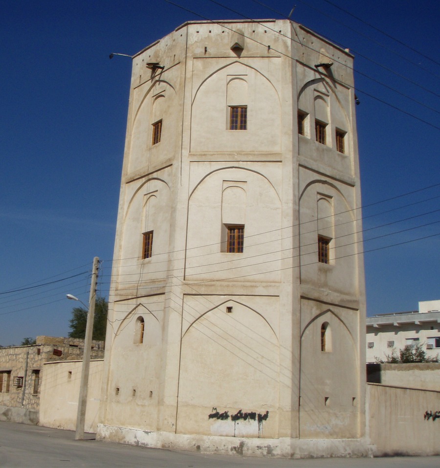
Figure 1. Remains of the Ḵˇormuj fortress. (Courtesy of Ivan Szanto, 2010).
In contrast to the coastal areas, the town and the sub-district have a moderate, dry climate. Local people are primarily farmers and silk producers. The chief products of agriculture are dates (see DATE PALM), grains, and tobacco. The three main plantations around the town are Bandu, Banga, and Širbanu. The only handicraft people still pursue in the region is cloak weaving (ʿabābāfi; see ʿABĀʾ).
Medieval sources do not disclose much about the history of the town, and it is not clear when the name was first adopted. In popular belief, the name of the town is derived from ḵˇor “sun” and mawj “wave,” due to the phenomenon of a wave of light cast by the rising sun over the town. According to another assumption, the name traces its origin back to Sasanian times and is a derivation from “Hormuz” (Ḥamidi, p. 290). This does not seem to hold true in light of the names appearing in historical works. The town is mentioned in the Ḥodud al-ʿĀlam, under the description of Fārs province, in the form “Ḵurmuk,” along with two other settlements, Jam and Kurān (Ḥodud, p. 127). All three were prosperous and populous boroughs within the limits of Sirāf. V. Minorsky explains that Ḵurmuk may either stand for ḵrbq or ḵrmq, the chief place of Aḡrestān, or Ḵormoj, north of the estuary of the Mānd (Ḥodud, p. 377). Moqaddasi notes that Ḵurmuq lies in the hot areas of Fārs (Moqaddasi, p. 394). Yāqut lists the town as Ḵormoq, a locality in Fārs (Meynard, p. 206; Yāqut, II, p. 361).
Between the 18th and 20th centuries, the rulers of the district, with their seat in Ḵˇormuj, came from the Dašti family, a line of hereditary khans of reputable Arab descent. They had migrated from Najd to southern Fārs in the 14th century under the leadership of Fāres b. Šahbān, but were entirely Persianized in subsequent centuries. From the 18th century, they held sway over the region, and they were obedient to Karim Khan Zand’s rule (Floor, p. 152). The Dašti khans actively participated in the battles leading to the expulsion of the British from Bušehr in 1919, as well as in the regional conflicts and interventions immediately following World War I (Anwari, pp. 352-54). The most notable chief in the family was Moḥammad Khan Dašti (1830-82), who reigned during the time of Nāṣer-al-Din Shah (Ḥamidi, p. 319). He built several roads and channels (kāriz), and laid the foundations for a flourishing literary life in Ḵˇormuj. In addition to poems, he wrote a maṯnawi titled Ketāb al-moluk, and Ketāb-e namakdān, a prose work in the style of Saʿdi’s Golestān.
David Lorimer gives a detailed account of Ḵˇormuj (Ḵormuj) after having visited the town in the 1910s (Lorimer, pp. 366-79, 1035). In his time, the town was adjoined by traces of an older one, which had been destroyed by the Persian governor of Shiraz at the beginning of the 19th century. Ḵˇormuj was a mercantile center consisting of about 350 houses. The population numbered 1,800; nearly all were Persian-speaking Shiites, with very few Arabs.
In the Qajar period, Ḵˇormuj was a center of learning and the birthplace of several writers and poets, among them Mirzā Jaʿfar Khan Ḥaqāyeqnegār Ḵˇormuji (1810-1883). He was the author of Āṯār-e jaʿfari (a geography of the world, with special attention to Fārs), the Ḥaqāʾeq al-aḵbār-e nāṣeri (a history of the reign of Nāṣer-al-Din Shah), where he for the first time described the true story behind the death of Mirzā Ṭaqi Khan Amir Kabir. He also composed two shorter prose works, Ḥaqāʾeq al-moṣiba dar tāriḵ-e Karbalā, and Nozhat al-aḵbār. Apparently, Nāṣer-al-Din Shah was not impressed by the candid treatise on his rule, and consequently Ḥaqāyeqnegār was exiled to Iraq, where he later died.
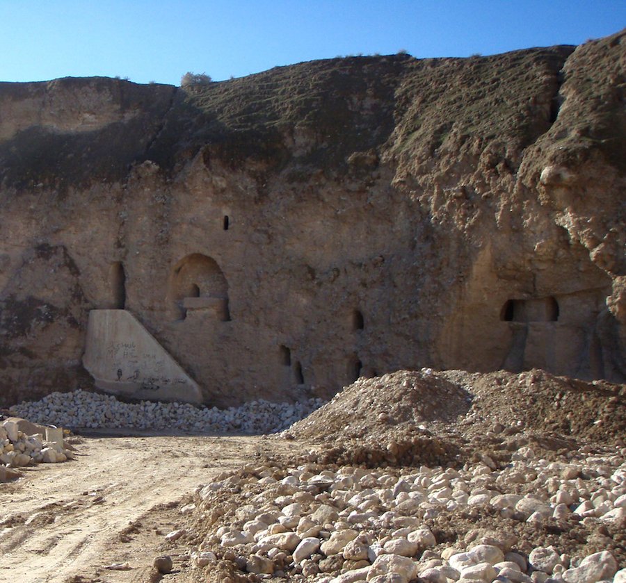
Figure 2. The fortress of Mond, near Ḵˇormuj. (Courtesy of Ivan Szanto, 2010).
Contemporary poets from Ḵˇormuj include Sayyed Musā Abṭaḥi (1933-1998), who wrote poetry in Persian and Arabic, and Sayyed Esmāʿil Behzādi (b. 1949), who published his collection Āvāy in 1991 under the pen name Ṣafā.
The town and the sub-district are home to a number of historic sites. In Ḵˇormuj stands the only remaining tower of Ḵˇormuj Fortress (qalʿa; Figure 1) or Moḥammad Khan Dašti Fortress, which was comfortable and elegantly furnished when Lorimer visited the building (Lorimer, p. 1035). Another residence built by Moḥammad Khan Dašti is the ʿEmārat-e Širina, located to the east of town close to the Banga date palm plantation. On the southern outskirts of Ḵˇormuj is a tomb (emāmzāda) believed to be that of Mir Eram, a grandson of Noah through Shem. On top of a rocky height on the east side of the Mond mountains, 30 km to the west of Ḵˇormuj, near Ḥaydari village, is Ḥaydari Fortress, also known as Qalʿa-ye Mond or Kalāt-e Mond (Figure 2). It is a rock-cut monument consisting of two chambers and numerous passages on four levels above the ground, built sometime between the 3rd and 10th centuries CE. According to local traditions, it served as a Zoroastrian fire temple (Ātaškada-ye Ḵˇormuj). This possibility was refuted by Ball and Whitehouse, who agreed that the structure had been used by a small religious community, but hypothesized that it had functioned either as a Buddhist or a Christian monastery (Ball and Whitehouse, p. 150).
Currently, the town of Ḵˇormuj incorporates five public parks, one hospital, one stadium, five major mosques, one ḥosayniya, and a branch of the Islamic Azad University.
Bibliography
A. H. Anwari, Ḵalij-e Fārs dar nima-ye noḵost-e qarn-e bistom, Tehran, 2011.
Warwick Ball and David Whitehouse, “Qalʿat-i Ḥaidarī,” Iran 14, 1976, pp. 147-50.
Ebn Ḥawqal, Ketāb ṣurat al-arḍ, tr. J. H. Kramers and G. Wiet, as Configuration de la terre, 2 vols., Paris, 1964.
Willem Floor, The Persian Gulf, The Rise of the Arabs, Washington, D.C., 2007.
Sayyed Jaʿfar Ḥamidi, Farhang-nāma-ye Bušehr, Tehran, 2001.
Ḥodud al-ʿālam, tr. Vladimir Minorsky as Ḥudud, al-ʿālam, The Regions of the World, 2nd ed., London, 1970.
John G. Lorimer, Gazetteer of the Persian Gulf, ʿOmān, and Central Arabia II, Farnborough, UK, 1970.
C. Barbier de Meynard, Dictionnaire Géographique, Historique et Littéraire de la Perse et des Contrées Adjacentes, Extrait du Moʿdjem el-Bouldan de Yaqout, Paris, 1861.
Moqaddasi, Aḥsan al-taqāsim fi maʿrefat al-aqālim, tr. B. A. Collins, as The Best Divisions for Knowledge of the Regions, Reading, 1994.
SCI (Statistical Center of Iran), Natāyej-e tafṣili-ye saršomari-e ʿomumi-e nofus o maskan 1385. Šahrestān-e Dašti, Bušehr, 2009.
Yāqut Ḥamawi, Moʿjam al-boldān, 5 vols., Beirut, 1955-57.
Ḥasan Zenda-del, Ostān-e Bušehr, Tehran, 1998.