

KERIYA (Chin. name Yutian), city and county in the southern Tarim basin in the Xinjiang Uyghur Autonomous Region, China. The subsistence agricultural economy of the oasis suffers from desertification and isolation. But the traditional Uighur oasis is located on the Silk Road. Archeological excavations during the last century have revealed the past splendor of the insignificant contemporary settlement.
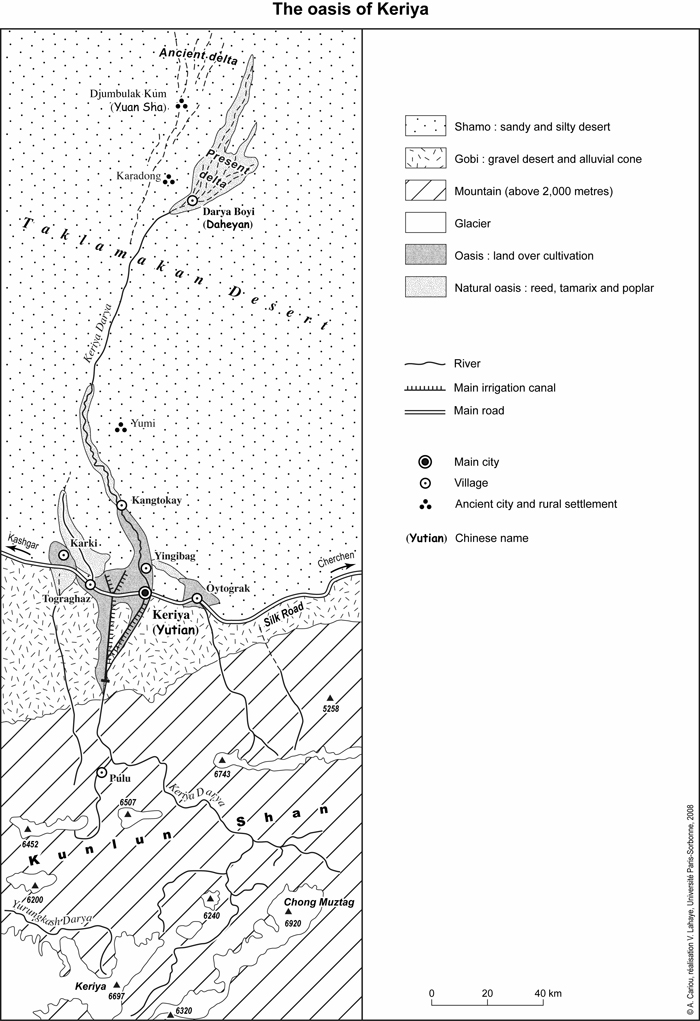
The city of Keriya is located between the northern foot of the Kunlun mountains and the edge of the Taklamakan desert, at an altitude of 1,459 m (FIGURE 1). It is the capital of Keriya County, which is one of the seven counties of the Khotan Prefecture. The administrative district comprises 39,126 sq. km, with a population of about 221,500 inhabitants in 2000 (Xinjiang Bureau of Statistics, 2001). About 93 percent of the native population are Uighurs who live in 15 small cities and villages in the piedmont oasis, in a typically rural setting. The flat-roofed houses are mostly traditional adobe buildings, surrounded by trees and scattered alongside canals whose water irrigates many small plots of land and orchards. A belt of thick poplar hedges surrounds the entire oasis (FIGURE 2). But Keriya is gradually losing its traditionally Uighur character. Because of the Chinese government program for urban development, Uighur neighborhoods are consistently demolished to make way for straight avenues and modern banal buildings. Moreover, the Chinese government is promoting the migration of Han Chinese through offering housing, education, and jobs in the administrative sector.
The continental climate of the Taklamakan desert is characterized by severe weather conditions. In July the average temperature is 25° C, and agriculture is thriving. The hot summer season is favorable for the cultivation of rice, wheat, cotton, alfalfa, vegetables, and fruits. But in the winter the area falls into a state of lethargy, when in January the average temperature drops to -6° C (Ling, p. 127). Since the average rainfall is only 50 mm per year, the oasis entirely depends on the Keriya river. The source of this endoreic (i.e. closed or inland) river is the center of the Kunlun mountain range, at an altitude of about 6,000 m, where glaciers and snow are usually melting in spring and early summer. The Keriya river irrigates the oases in the alluvial fan deposits of the piedmont, which are the borderland between the Kunlun mountains and the drifting sand dunes of the Taklamkan desert. Between the end of the last glacial period about 9,700 BCE and 4,000 BCE, the Keriya river flowed into the Tarim river, but nowadays the Keriya river vanishes in the sands of the Taklamakan desert. Since the 1950s, when a water conservation network of diversion, storage, regulation and transportation has been set in place, the Keriya river has been intensely exploited. Some 3,300 km of irrigation canals and ditches have been built (Cheng, pp. 134-39) to increase the irrigated area from 16,666 ha in 1949 to 26,000 ha in the first decade of the 21st century. In early summer, the river reaches a wide inner delta of natural vegetation (Turk. togkai; cf. Tian, p. 100), about 180 km north of the city of Keriya. Small groups of Uighurs herd their sheep, goats, or camels among reed, tamarix, and poplars surrounded by sand dunes.
Keriya’s ancient history was unknown until the Swedish explorer Sven Hedin (1865-1952) discovered the oasis in 1896. Following the lower Keriya river, he found the ruins of the ancient city of Karadong which is now buried beneath the sands (Hedin, 1899). When Aurel Stein (1862-1943) visited the archaeological site in 1901 and 1908, Karadong was a neglected oasis with a small fort, surrounded by agricultural settlements and the remains of poplar forests (Stein, 1904). Between 1993 and 2005, Sino-French archeological expeditions systematically surveyed the delta of the Keriya river and found many similar sites, for example Djumbulak Kum (Chin. name Yuan Sha). The expeditions’ fieldwork has documented more than 20 lost cities distributed alongside abandoned riverbeds in the sands of the Taklamakan desert (Debaine-Francfort and Idriss).
The occupation of the oasis of Keriya can be traced back to the Iron Age. During the first millennium BCE sedentary agropastoralists developed an irrigation system that permitted a subsistence agricultural economy based on the cultivation of millet, barley and wheat, as documented for Djumbulak Kum. During the first three centuries CE, Karadong was the capital of the oasis of Keriya. It served as stopover on the famous Silk Road, which was the main caravan track from China to the West Eurasia, that is: the Middle East and southern Europe. But Keriya also was the starting point of an old road across the Taklamakan desert, that followed the paleochannel of the Keriya river and which connected oases on the northern and the southern edge of the Tarim basin. Although the kingdom of Keriya was under the suzerainty of the Han dynasty (206 BCE-220 CE), excavated buildings and artifacts document the cultural influence of Gandhāra, a region in the extreme northwest of the Indian subcontinent. For example, in Karadong Buddhist temples were decorated with paintings and stucco walls in the Greco-Buddhist style, typical for Gandhāran art. Keriya was located on a southern branch of the Silk Road, and its artwork, like that of the neighboring kingdom of Khotan, mixed elements of Persian, Indian, Greek, Tokharian, and Chinese art. In the later Han Chronicle (Hou Han-shu), the kingdom of Keriya was known as Jumi.
The flourishing life alongside the lower Keriya river declined in the fifth century CE, when a tectonic upheaval of the Kunlun and Pamir mountains diverted the course of the river to the southeast. The inner delta dried up, and therefore, the oasis moved southward to the foothill of the mountains. When Marco Polo (1254-1323?) visited Keriya in 1275, the capital city was called Pem, the province possessed many towns and villages, and it took five days to cross the oasis from east to west. Marco Polo described the abundance of cotton and precious stones, such as jasper and chalcedony, easily found in the riverbed. The inhabitants were Muslims, whose livelihood was mostly to come from trade and industry (Marco Polo, p. 136).
At the end of the 19th century, about 15,000 people lived in the city of Keriya (Reclus, p. 140). C. P. Skrine (1888-1974), who from 1922 to 1924 was stationed as British consul in Kashgar, described the city as the end of the world. Nowadays, Keriya remains a traditional Uighur oasis. The densely populated settlement suffers from desertification, isolation, as well as a lack of water and arable lands despite the numerous Chinese government programs for water conservation and land improvement.
Bibliography:
Corinne Debaine-Francfort and Abduressul Idriss, Keriya: Mémoires d’un fleuve – Archéologie et civilization des oasis de Taklamakan, Paris, 2001; exhibition catalogue.
H. Cheng, “The Change of Eco-environment and the Rational utilization of Water Resources in the Keriya River Valley,” in Reports on the “1986 Sino-German Kunlun-Shan Taklimakan Expedition,” ed. D. Jäkel and Z. Zhenda, Die Erde, Special Issue 6, 1991, pp. 133-47.
Sven Hedin, Through Asia, tr. from the Swedish by J. T. Bealby, 2 vols., New York, 1899.
Sven Hedin et al., Scientific Results of a Journey in Central Asia 1899-1902, 8 vols., Stockholm, 1904-1907; 6 vols. of text and 2 vols. of atlas.
Peter Hopkirk, Foreign Devils on the Silk Road: The Search for the Lost Cities and Treasures of Chinese Central Asia, London, 1980.
George Kish, To the Heart of Asia: The Life of Sven Hedin, Ann Arbor, Mich., 1984.
Y. Ling, “Climatic Characteristics and their Changing Tendency in the Taklimakan Desert,” in Reports on the “1986 Sino-German Kunlun-Shan Taklimakan Expedition,” ed. D. Jäkel and Z. Zhenda, Die Erde, Special Issue 6, 1991, pp. 122-32.
Mikhail P. Petrov, Pustyni tsentral’noĭ Azii, 2 vols., Moscow, 1966-67, esp. II, pp. 141-234.
Marco Polo, Le devisement du monde: Le livre des merveilles, ed. A. C. Moule and P. Pelliot, tr. into French by L. Hambis, with introduction and notes by St. Yerasimos and maps by P. Simonet, Paris, 1996; orig., 2 vols., Paris, 1980.
Elisée Reclus, L’Asie orientale, Nouvelle Géographie universelle: La terre et les hommes 7, Paris, 1882.
Clarmont P. Skrine, Chinese Central Asia, London, 1926; repr. with new preface, Chinese Central Asia: An Account of Travels in Northern Kashmir and Chinese Turkestan, New York, 1986; Lahore, 1996.
Aurel Stein, Sand-Buried Ruins of Khotan: Personal Narrative of a Journey of Archaeological and Geographical Exploration in Chinese Turkestan, London, 1903.
Idem, Ruins of Desert Cathay: Personal Narrative of Explorations in Central Asia and Westernmost China, London, 1912.
Idem, On Ancient Central-Asian Tracks: Brief Narrative of Three Expeditions in Innermost Asia and North-Western China, London, 1933.
Y. Tian, “Tokai on the delta at lower reach of the Keriya River,” in Reports on the “1986 Sino-German Kunlun-Shan Taklimakan Expedition,” ed. D. Jäkel and Z. Zhenda, Die Erde, Special Issue 6, 1991, pp. 99-112.
Xinjiang Bureau of Statistics, Fifth Census 2000, Beijing, 2001.
Idem, Xinjiang Tongji Nianjian 2001 (Xinjiang Satistical Yearbook), Beijing, 2002.
(Alain Cariou)
Originally Published: May 25, 2010
Last Updated: May 25, 2010
Cite this entry:Alain Cariou, “KERIYA [2010],” Encyclopædia Iranica, available online at http://www.iranicaonline.org/articles/keriya-archived (accessed on 30 November 2012).