

KARUN RIVER (Rud-e Kārun), the largest river and the only navigable waterway in Iran. It flows out of the central Zagros range, traverses the Khuzestan plain, and joins the Shatt al-Arab before the latter discharges into the Persian Gulf. This entry will be divided into the following three sections:
ii. Historical geography. [Forthcoming]
iii. The opening of the Karun.
The river Karun has its rise in the Baḵtiāri Zagros mountains west of Isfahan and follows a meandering course to the Persian Gulf. A straight line between the source and the mouth measures only about 250 km, while the river actually travels between 860 and 890 km. The loops are sizeable in the mountains and much more frequent on the plain. The river’s course can be divided into three natural sections: (1) the upper, mountainous course from its source to Gotvand, where it leaves the mountains, about 400 km downstream; (2) the middle course, from Gotvand, through Šuštar, to its junction with the Āb-e Dez, then all the way south to the rapids of Ahvāz; and (3) from Ahvāz across the rest of the Khuzestan alluvial plain, where the river flows gently towards the Shatt al-Arab.
The upper course. The source of the Karun is the western spurs of Kuhrang in the heart of Baḵtiāri land, about 75 km west of Isfahan. It is called Sarčašma-ye Kuhrang, not far from the source of the Zāyandarud, which flows eastwards onto the Isfahan plain. Diverting dam-and-tunnel systems between the sources of the two rivers have been constructed to redirect the headwaters of the Karun into the Zāyandarud (see below).
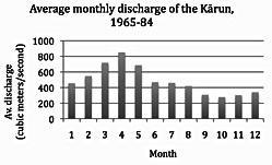
The upstream section of the Karun can be characterized as a steep, powerful stream, descending through a series of mountainous anticlinal ridges and synclinal valleys, and for long stretches the river flows rapidly between lofty cliffs. As the river flows downward, its volume increases almost constantly, as it is nourished by springs and snowmelt channeled into the tributaries that successively join the Karun. Among the approximately two-hundred streams that comprise the upper Karun, some of the major ones are listed in Table 1. Up to its confluence with the Beheštābād river, at a point 120 km downstream from the Karun’s source, the river is often called by the name of its source, Kuhrang.
In spite of its significantly meandering course, the river runs mostly in a southerly to southeasterly direction until the powerful tributary Vanak diverts the Karun’s course in a southwesterly direction, which is generally maintained even when the Bāzoft, one of its main tributaries, merges in. Another major orientation change occurs at the next chief tributary, the Ḵersān, which actually takes the Karun into its own northwesterly direction, a direction which the Karun follows for much of the rest of its upper course. However, a full, convex, southward curve begins at the confluence with the Āb-e Šallā, countered by a remarkable concave bend at the Sabzāb, and lastly another huge curvature between Āb-e Kiā and Gotvand village, where the Karun exits the mountains. It continues the rest of its course in an average southward direction (Adamec, pp. 393-94; Gitāšenāsi, plates 57, 70-72).
The middle course. The Karun departs the mountains at a 5-km long defile known as Tang-e Qalʿa Doḵtarān and meets the village of Gotvand on its right bank. Here it flows around the fertile plain of Aqili (or Aḡili/Aḵili; Lorimer, pp. 90-93) in a curve before it passes through a hilly stretch. A few kilometers down, the Karun swings westward, and just before it reaches the old Šuštar, 30 km downstream from Gotvand, it bifurcates into two navigable arms. The left/west arm makes the Karun proper, also known as Āb-e Šoṭayṭ “little river” (Lorimer, pp. 1770-73: Shatait) and, farther downstream, as Āb-e bozorg-e Šustar “great stream of Šustar.” The right/east arm, Āb-e Gargar, is artificial in origin (Lorimer, pp. 563-72). The two arms are also called Čahārdānga (left) and Dodānga (right). The island between the two temporary arms, Miānāb or Miāndāb (idem, pp. 1235-38), embraces the town of Šuštar and stretches southward some 45 km to the village of Band-e Qir (or Bandakil; Lorimer, p. 259), which stands at the southern apex of the island.
Here, not only do the two arms of the Karun reunite, but also the Āb-e Dez, flowing in a southeastward direction, unites with the Karun from the right/west. Significantly enlarged by the Dez, the Karun now flows 250-300 meters wide for some 20 km straight southwards, up to the village Veys (Lorimer, p. 1925). From Veys southwest to Ahvāz the river winds in three sharp meanders for 45 km—over twice the straight line distance. From the junction at Bande Qir to Ahvāz the Karun flows some 74 km.
Just before reaching Ahvāz, and after the small island of Omm-al-Naḵl, the Karun breaks through the sandstone hills known as the spurs of the Jabal Ḥamrin. This gives rise to the 3-km long rapids of Ahvāz, locally known as Pers. band or Ar. sadd (Lorimer, pp. 983-84; also pp. 1361-62, under the town of Nāṣeri). Except for these rapids, the middle and lower courses of the river are navigable, although below Ahvāz the riverbed is not always deep enough for navigation (ibid.).
The lower course and the delta. After bisecting modern Ahvāz, the river continues in a general southerly direction, within a series of bends and convolutions, and then flows straight southwest towards its mouth at the Shatt al-Arab (in Persian: Arvand Rud). The river’s lower course runs gently through the alluvial plain formed by the Karun itself. Its average slope here is 8 cm in a km (Lorimer, p. 986); this is 0.008 percent, compared with a slope average of more than 3 percent for the entire course of the Karun.
The Kārun delta begins some 5 km above Ḵorramšahr, where the river bifurcates into two major branches, either of which may be regarded as the river’s natural mouth (cf. Streck; Moṣāḥab, II, pp. 2133-34). (1) The shorter branch, still called Karun, flows a few kilometers westward, until it meets the Shatt al-Arab, already an effluent of the Euphrates and Tigris. Now expanded by the Karun, the Shatt al- Arab runs southeast for about 200 km before joining the Persian Gulf (Rzóska, p. 47). (2) The Bahmanšir branches off the left bank of the Karun and flows 70-80 km in a channel 500-800 meters wide, parallel with the Shatt al-Arab, with which it forms the island of Ābādān; it flows into an estuary (ḵor, ḵowr or ḵawr) called Ḵor-e Bahmanšir before entering the sea.
Two other distributaries, into which the Karun historically changed course alternately, branch off left of the Karun’s delta and run southeast toward their estuaries at the Persian Gulf. (1) The Šaṭṭ al-Aʿmā, known also as Māred al-Aʿmā and Šaṭṭ Qobān, traverses the marshlands until it spreads into the Ḵor-e Silij. (2) The Qadimi the old stream, so called on account of it being considered an old bed of the Karun, finally broadens out into the Ḵor-e Musā . (For a list of littoral settlements on the Karun, downstream from the confluence with the Dez, see Lorimer, pp. 987-92; reprinted in Adamec, pp. 397-404.)
Islands. Alluvial sedimentation over time has resulted in the formation of several islands in the lower Karun. Here is a list from north to south: Veys, Loqbeyr, Ḵoveysa, Jazirat al-Āghā, Omm-al-Naḵl, Omm-al-Se/abāʿ, Abu Debbes, Kareyšān, Jazirat-al-ʿAmayra, Eṯla, ʿAżrāt, Salmāna, and Jazirat-al-Dāʿer (Lorimer, p. 993).
The basin and discharge. The Karun drains an area of around 60,000 km2, two-thirds of which is mountainous and a third of which is piedmonts and plains; a third of this catchment basin belongs to the Dez, the main tributary of the Karun. The main source of the Karun in the central Zagros (see above) is covered with snow for up to five months a year and receives annual precipitation rates of up to 600 mm. The majority of the precipitation occurs in winter, mostly from October until May (Vali-Khodjeini; Jaʿfari, p. 343; Afkhami et al.).
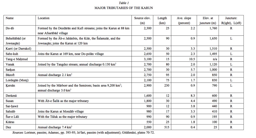
The river regime of the Karun is characterized by a fairly delayed flow-off, with peaks in late spring and early summer (Beaumont, pp. 11, 14). Aside from the precipitation cycles, the runoff patterns of the Karun are affected by various forms of human interference, especially dam construction. Before these human influences, in the early 20th century, the discharge was measured as a range from a minimum of 280 m3/sec. to the flooding rate of 3,700 m3/ sec. (Lorimer, p. 986); a later account places the minimum discharge at 200 m3/sec. in October and the maximum discharge at 1,700-2,100 m3/sec. (Oberlander, 1968, p. 269). Figure 1 shows the average monthly yield of the Karun, observed from 1965 to 1984. The highest rate of 853 m3/ sec. occurs in April and the lowest rate of 279 m3/sec. in October. Over the twenty years of data collection the highest average of 1,139 m3/sec. occurred in 1969 and the lowest average of 128 m3/sec. in 1977. The overall average rate is 481 m3/sec., corresponding to the average 15.2 km3 of water discharged each year (cf. 18.7 km3 in Jaʿfari, p. 343; 22 km3 in Afkhami et al.; cf. Razmārā, p. 29). See also DRAINAGE ; HYDROLOGY ii. SOUTHWESTERN PERSIA; FLOODS i. GEOGRAPHY.
Having many affluents at a relatively short distance from the mouth, compounded with heavy cyclonic rainfall over Khuzestan and the Zagros range, the Karun is prone to more violent and irregular changes in its levels than either the Tigris or the Euphrates. As a result, major flooding of the marshes around the Karun is a comparatively regular event. Severe damage is caused by the recurring inundation of farmlands and the flooding of settlements and roads. Flooding, in combination with high groundwater levels and high evaporation rates in the summer, contribute to severe salinity of the soil. The soil, poorly drained, contains relatively large quantities of soluble salts, hence its unsuitability for agricultural use.
Dams. The traditional hydrology of the Karun has been radically impacted by the construction of several dams since the mid-20th century. The first of these was the Kuhrang dam-and-tunnel system at the headwaters of the Karun, to divert the water that would have eventually joined the ocean into the Zāyandarud, which flows into the inner Iranian plateau. The first Kuhrang diverting tunnel (2.7 km long) was constructed in 1948-53; two more tunnels have since been dug (see isfahan xiv. MODERN ECONOMY AND INDUSTRIES [1] THE PROVINCE).
The upper course of the Karun and its tributaries has also been exploited by the construction of several dams. These serve the purpose of controlling floods, storing water for irrigation, and generating hydroelectric power. The first dam on the Karun, completed in 1978, is commonly referred to as the Karun I dam (the official name, initially Reza Shah the Great, was changed after the Islamic Revolution of 1979 to Šahid ʿAbbāspur). The concrete-arch dam was built at the entrance of a gorge, behind which a large lake has been formed. Three more dams completed to date (Table 2) are also reinforced concrete arched dams, and a Karun V dam upstream from Karun IV has been proposed. Dams are also built on the Karun’s tributaries. Aside from the iconic dam on the Dez, a Baḵtiāri dam is reportedly under construction, while more dams are projected to regulate the Ḵersān, Liro, and Bāzoft rivers, among other tributaries of the Karun. These projects, ambitious as they are, trouble those who are concerned about the ecology of the region, the sediment transport, and the relocation of settlements.
Before the construction of the dams, the Karun was utilized for irrigation only on a minor scale, principally by means of water lifts on the banks which were worked by animals (Lorimer, p. 986). Modern irrigation projects have benefitted from the regulated flow of the Karun, which is estimated at more than 160,000 hectares from Šuštar in the north to the Bahmanšir in the south (see also ĀBYĀRI; AGRICULTURE).
Bridges. Before the introduction of modern technology, bridges existed only in the mountainous course of the Karun, as European travelers reported in the 19th and early 20th centuries (see Table 3). These included timber bridges of impermanent nature in the highest cols, and stone and mortar constructions in the rest of the upper course of the Karun. These bridges were too few and too widely dispersed to facilitate communication across the Karun on any significant scale. The Baḵtiāri tribesmen, in their annual migrations, often had to cross this winding river more than once each way. The crossing of the Karun by the Baḵtiāris is documented in the 1925 silent film Grass: A Nation’s Battle for Life; in dramatic sequence, it depicts the herders moving their flocks to high summer pastures across the treacherous river.
In the middle course of the river, the remains of the extensive infrastructure built under the Sasanians (see History, below) include fragments of the Band-e Qayṣar above Šuštar and another barrage, the Band-e Qir (see band), which marks the end of the middle course of the Karun, as explained above. Several bridges across the Karun on the plain of Khuzestan have been constructed since the Pahlavi era (Sāzmān-e Fār, p. 277). The monumental steel arch bridge in Ahvāz was a symbol of the nation’s technological advancement before the Islamic Revolution.
For the history of shipping on the river, see iii. THE OPENING OF KARUN.
Bibliography:
The most detailed descriptions of the Karun and its littoral can be found in 19th-century British literature, a bibliography of which is listed in Curzon, 1890, pp. 509-10. The largest compilation on the Karun is found in Lorimer’s Gazetteer (see below).
Ludwig Adamec, ed., Historical and Political Gazetteer of Iran III, Graz, 1989.
Mehran Afkhami et al., “Regional Water Quality Management for the Karun–Dez River Basin, Iran,” Water and Environment Journal 21, 2007, pp. 192–99.
W. F. Ainsworth, A Personal Narrative of the Euphrates Expedition, 2 vols., London, 1888; II, pp. 168-88, 205, 219-32.
Idem, The River Karun, London 1890.
Peter Beaumont, River Regimes in Iran, Univ. of Durham, Dept. of Geography Occasional Publ., N.S. 1, Durham, 1973.
Idem, “Water Resource Development in Iran,” The Geographical Journal 140/3, 1974, pp. 418-31.
Merian C. Cooper, Grass, New York and London, 1926.
Merian C. Cooper and Ernest B. Schoedsack, dirs., Grass: A Nation’s Battle for Life, Paramount Pictures, 1925; 35mm film and videorecording, Harrington Park, N.J., 1999.
G. B. Cressey, “The Shatt al-Arab Basin,” Middle East Journal 12, 1958, pp. 448- 60.
G. N. Curzon, “The Karun River and the Commercial Geography of South-West Persia,” Proceedings of the Royal Geographical Society 12/9, 1890, pp. 509-32, esp. pp. 516-17.
Idem, Persia and the Persian Question, 2 vols., London, 1892, II, pp. 341-42.
Eckart Ehlers, Traditionelle und moderne Formen der Landwirtschaft in Iran, Marburger Geographische Schriften 64, Marburg, 1975.
Idem, Iran. Grundzüge einer geographischen Landeskunde, Wissenschafliche Länderkunden 18, Darmstadt, 1980.
Gitashenasi Institute, Atlas-e rāhhā-ye Irān, Tehran, 2007.
Harza Engineering Company International, Karun River Development, n.p., 1967.
ʿAbbās Jaʿfari, Gitā-šenāsi-e Irān II, Tehran, 1997.
N. Jafarzadeh et al., “Identification of the Water Pollutant Industries in Khuzastan Province,” Iranian Journal of Environmental Health Science and Engineering 1/2, 2004, pp. 36-42.
Masʿūd Keyhān, Joḡrāfiā-ye mofaṣṣal-e Irān, 3 vols., 1931-32.
J. G. Lorimer, Gazetteer of the Persian Gulf, Omān And Central Arabia II. Geographical and Statistical, Calcutta, 1908; repr. in two volumes, Westmead, UK, 1970.
Henry Blosse Lynch, “Notes on the Present State of the Karun River, between Shushter and the Shatel- Arab,” Proceedings of the Royal Geographical Society 13/10, 1891, pp. 592-95.
Idem, “Across Luristan to Isfahan,” Proceedings of the Royal Geographical Society 12/9, 1890, pp. 533-52.
Ḡolām-Ḥosayn Moṣāḥab, Dāyerat al-maʿāref-e fārsi I-II, Tehran, 1966-77.
Theodore M. Oberlander, The Zagros Streams: A New Interpretation of Transverse Drainage in an Orogenic Zone, Syracuse Geographic Series 1, Syracuse, 1965.
Idem, “The Origin of the Zagros Defiles,” in W. B. Fisher, ed., Cambridge History of Iran I, Cambridge, 1968, pp. 264- 79.
Ḥosayn-ʿAli Razmārā, Farhang-e joḡrāfiāʾi-e Irān VI, Tehran, 1951.
S. Rostami et al., Final Report of Study and Environmental Management of Water Sources— Karun River, Khuzestan Dept. of Environment, Ahvāz, 1997.
J. Rzóska, Euphrates and Tigris, Mesopotamian Ecology and Destiny, The Hague, Boston, and London, 1980.
Sāzmān-e Fār, Rāhnemā-ye šahrestānhā-ye Irān barāye mohandesin-e mošāwer. . . , ed. Ebrāhim Eṣlāh- ʿArabāni, Tehran, 1967.
P. Y. Shourijeh et al., “Karun River Hydropower Cascade Development and its Socio- Environmental Impacts,” in L. Berga et al., eds., Dams and Reservoirs, Societies and Environment in the 21st Century I, London, 2006, pp. 289-92.
Sofel Environmental Engineers, Final Report of Karun River Quality, Ahvāz, 1981.
M. Streck [J. Lassner], “Kārūn,” in EI² IV, 1978, pp. 673-76.
(Habib Borjian)
Originally Published: December 15, 2011
Last Updated: April 24, 2012
This article is available in print.
Vol. XV, Fasc. 6, pp. 629-633