


ISFAHAN
xiv. MODERN ECONOMY AND INDUSTRIES
(1) Modern Economy of the Province
On the whole Isfahan is an average province within Persia in terms of general economic indices: in the year 2000 the province contained 6.5 percent of the population of the nation, 6.3 percent of its GDP, 6.5 percent of its total household expense, and 6.5 percent of its budget and public expenditure (Sāzmān-e barnāma, 1997, XXVII/4; cf. Akbari, p. 86). As elsewhere in Persia, the economic infrastructure of the province remains fairly underdeveloped. Modern highways and railways are limited to the transnational arteries crossing the province. The rural economy remains largely peasant-oriented, utilizing traditional irrigation techniques and rudimentary mechanization. The industrial labor is largely untrained, and higher education has become increasingly superficial and does not provide the basic skills needed for a modern economy.
The distribution of economic activities within the province, with an urbanism of 76 percent, is highly uneven. The oasis of Isfahan, watered by the Zāyandarud, is responsible for nearly half of rural activities, while the other half is spread out across the province. The main disparity, however, is the uneven distribution of modern industries, the bulk of which is located in Isfahan proper in a chain of large agglomerations within a fifty-mile radius of the city. This means that Isfahan ranks as the second most important industrialized region in Iran after Tehran. The only other town of the province with some degree of industrial development is Kāšān. The industries of the city of Isfahan will therefore be treated separately (see 2 below; for uneven provincial distribution of natural resources and population see i and iii above).
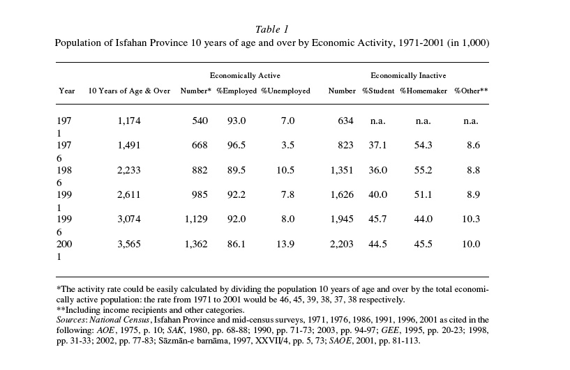
Labor force. In the province of Isfahan, as illustrated in Table 1, the labor force shows a continuous growth in the last three decades, corresponding to the remarkable increase in population. Between 1971 and 2001 the labor force (i.e., the economically active population ten years of age and older) grew from 540,000 to 1.36 million, while employment rose from 502,000 to 1.17 million, implying that the unemployment rate rose from 7 to 14 percent. The startling unemployment growth after the Revolution is a result of population explosion, compounded by the influx of war refugees from Ḵuzestān (Hourcade, p. 53), and Afghan immigrants (estimated at between 50,000 and 200,000; see DIASPORA x. AFGHAN REFUGEES IN PERSIA) into the labor market (cf. Anṣāri, pp. 62-63). These developments occurred in spite of a substantial decline in the number of women participating in the work force. In the post-revolutionary decade the women’s share of employment in the province saw a sharp drop from 18.8 to 9.0 percent from 1976-86; it rose, however, in the next ten years to 14.6 percent. This may readily be explained by unfavorable social policies toward women, especially of the first post-revolutionary decade; the ratio of housekeepers (more than 99 percent women) among the inactive population of the province rose 67 percent in 1976-86, compared with a mere 15 percent growth in the next ten-year period. Not as clear is the cause of the decline of women’s share in the rural economy that saw a steady drop from 26.6 to 9.1 percent in 1976-91 (Sāzmān-e barnāma, 1997, XXVII/4, pp. 68-72, 99). The economic inactivity of women contributed to the sizeable drop in the general economic activity rate of the province, from 45 percent before the Islamic Revolution to an average of 38 percent in the post 1979 period (ibid), as listed in Table 1.
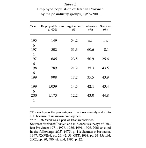
Similar to many other provinces, the bulk of the growth in employment has been in the service sector, with an increase from 25.6 percent in 1976 to 42.2 percent in 1986 and further to 46.8 percent in 2002. The service sector employed 591,000 persons in 2000, of which a quarter were active in wholesale, retail, and repair, a fifth in construction, a seventh in transportation and communication, and 2 percent in energy (Akbari, pp. 86-87). Despite a slight change in total employment in the agricultural sector, its share in total employment fell from 31.3 percent in 1971 to 12.2 in 2001. Industrial employment declined after the Revolution, before the trend was reversed in the late 1980s. By 2001, however, it constituted 43.0 percent of the total employment, compared with 50.9 in 1976 (see Table 2). There was also a marked shift to the public sector in the structure of employment. Public employees constituted 37.3 percent of the working population in 1991, up from 20.0 percent in 1976 (Sāzmān-e barnāma, 1997, XXVII/4, pp. 45, 48, 88; SAOE, 2001, p. 118; cf. ibid, pp. 112-13) and about 4 percent in 1956 (Edāra-ye āmār-e omumi, p. 97). While part of this increase comes from extensive nationalization, much of it is due to the creation of new jobs in the state sector.
In 1996 the district of Isfahan alone constituted 41.0 percent of the total working population of the province, followed by Kāšān, Najafābād, and Ḵomeynišahr with 10.3, 8.0, and 5.6 percent, respectively. The district of Isfahan’s share in the service, industrial, and agricultural sectors of the province was 50.3, 37.3, and 21.7 percent, respectively (Sāzmān-e barnāma, 1997, XXVII/4, pp. 16-21, 31-38).
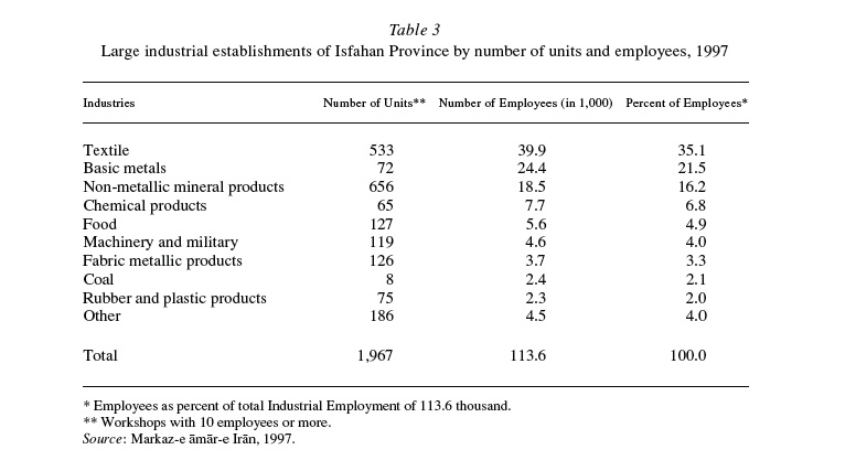
The industrial units and employment in Isfahan province for the workshops with 10 or more employees in 1997 are shown in Table 3. The total of 1,967 such units employing nearly 114,000 workers constitute 14.1 and 13.0 percent of corresponding national figures, respectively, and rank Isfahan the highest after Tehran among all provinces of Persia (Baḵtiāri, p. 22). The textiles, basic metals, and mineral products each employ more than 10 percent of total industrial employment, and chemicals, food, and machinery industries follow suit in rank. Largest of the units are the two gigantic steel mills (see 2 below), which belong to basic metals industry with an average of 339 employees per unit. The same average was 75 for the textile industry which consists of hundreds of small and medium sized workshops distributed throughout the province and a dozen or so large factories in Isfahan. The overall distribution in terms of number of employees was highly uneven: only 27 units employed more than 500 workers, while over 77 percent of the units had less than 30 employees. The state-owned units were as few as 32, but employed nearly a quarter of the industrial labor force (Baḵtiāri, p. 32; cf. Bank-e Markazi, p. 59).
Water management. The province of Isfahan falls into the arid and semi-arid zones and like much of the Iranian plateau suffers from shortage of water, the most important limiting factor in its agriculture (see i. above). The rainfall in the province is half that of the national average and less than one-sixth of the world average (Wezārat-e kešāvarzi, 1997, p. 1). Due to the low rate of precipitation, dry farming is confined to the western highlands for cultivation of wheat and barley.
In areas away from the streams, subterranean waters were utilized through a system of qanāts, but these have been gradually abandoned due to their costly maintenance (cf. Hartl). In the 1940s power pumps were introduced, and the use of deep and semi-deep wells (30 m and more) as well as pumping from rivers rapidly expanded and gained prevalence. The mechanized wells reach to the rather shallow water tables around the traditional water nuclei, many of which have already been sucked dry; nonetheless, the number of deep and semi-deep wells has been on the rise and by the turn of the century had grown to 6,541 and 14,415, respectively (SAOE, 2001, p. 231). Diverting water from rivers has been a major source of irrigation in the lower course of the Zāyandarud river (Cordonnier; ʿĀbedi, p. 78; Ṭalāmināʾi, p. 117).
Zāyandarud is the only major river in the province. It irrigates the traditional districts (boluks) of Čahārmaḥāl, Fereydan, Lenjānāt, Mārbin, Jay, Barzrud, Karāraj, Barāʾān, and Rudašt, before entering the Gāvḵuni (q.v.) lagoon. From Safavid times, the stretch of the river downstream from Lenjān has been regulated by an elaborate system, the details of which are found in a document known as the Shaikh Bahāʾi’s ṭumār, dated 923/1527. Its underlying principles are based on the requirements for cultivation and the varying need for water of crops sown in each district. The river waters were allotted according to three distinct property rules, each was further divided on principles based on district, irrigation channels (mādis), and villages. This system underwent alteration in 1936, owing to the fact that, on government orders, the cultivation of cotton was substituted in the lands watered by the river for the cultivation of rice (Taḥwildār, pp. 38-41; Lambton). These legal principles are still essentially in effect with certain modification (ʿĀbedi, pp. 68-73).
In order to increase and control the Zāyandarud’s flow, two major projects were carried out in the 20th century through heavy investment by the central government. The first one was the construction of the Kuhrang dam and tunnel system to divert the headwaters of the Kārun into the upper reaches of Zāyandarud, thus stabilizing the water supply of Isfahan and its environs. (An early effort in the Safavid period had failed; see Eskandar Beg I, pp. 949-50) The first Kuhrang diverting tunnel (2.7 km long), constructed in 1948-53, increased the river water by a third to an average annual 1,250 million m3 (FJI, p. 163; ʿĀbedi, pp. 74-76). Since then two more tunnels have been dug, and attempts have been made to modernize the agricultural channels. Moreover, a pipeline carries a share of the water surplus as far as Yazd, now benefiting from the water that would otherwise discharge into the Persian Gulf from the Kārun river. The second major project was the construction of a 100 m high, arched concrete dam, named after Shah ʿAbbās the Great, over the Zāyandarud upstream near Čādagān. The dam became operative in 1971. Its reservoir has a capacity of 1.1 km3 and controls water for irrigation of 95,000 hectares of land, particularly those of the downstream districts which receive little water during the summer, when it is most needed (Šafaqi, pp. 80, 86; U.S. Department of Commerce, p. 74; GEE, 2002, p. 493).
Moreover, several earthen dams are constructed to aid irrigation. The Golpāyagān dam, the first modern dam in the nation, was built in 1957, with a reservoir capacity of 0.45 km3. Other significant embankment dams are the Ḥanā dam in Semirom and Ḵomirān dam on the Morḡāb near Tirān, west of Isfahan, with 0.45 km3 and 0.06 km3 reservoirs, respectively (GEE, 2002, p. 493).
Farming. Mountains, barren desert, and desert-steppe that cover the biggest expanse of the province are at best usable only for periodic pasturing. The agriculturally usable land is limited to a twentieth of the total land. The most fertile part of the province is the Zāyandarud valley, with the landscape mostly covered by farms and is still dotted by “pigeon towers” once used for collecting pigeon manure to fertilize melon fields (Wulff, p. 270). The agricultural condition of the Isfahan district in the early 1920s is best summed up by Arthur Chester Millspaugh: “The soil is clay and chalk mixed in some section with fine sand. Alfalfa, clover, and maize are cultivated successfully. The climate is favorable for growing mulberry trees and gape. The inhabitants are penurious, credulous and satisfied. Apples, pears, apricots, and peaches are of remarkable size and flavor, and the quinces and melons are the best in Persia. Tobacco and cotton are also important crops. Rice is also produced in some districts” (Millspaugh, p. 256).
Opium was the only cash crop that contributed substantially to the export trade (idem, pp. 191, 258). Much of the commercial activity in the bazaar in the latter half of the 19th century related to the trade of opium which, as the major cash crop, was cultivated in large quantities around Isfahan, with its export paying for the European industrial imports. “Out of a population of approximately eighty thousand, there were at least five thousand who gained all or a large part of their income through the commerce of opium. These included opium-peddlers, brokers, bazaar traders, commission and export merchants, packers, porters, coppersmiths, and the manipulators of the stick and cake opium. If we assume an average of three dependents, which is low, it will be seem that at least a fourth of the entire population of the city was largely dependent on opium trade. The above figures, moreover, do not include the opium-cultivators resident in or near the city” (Millspaugh, p. 190). The fact that the opium sap was used as a means of exchange instead of cash in many businesses demonstrates the significance of opium for the Isfahan economy. When the government centralized the opium trade by taking over its distribution and imposing taxes on revenue from its cultivation in 1923, the fear of loss of jobs prompted a fierce resistance in Isfahan which manifested itself in rioting and turmoil, but the law was ultimately implemented (idem, pp. 191, 259).
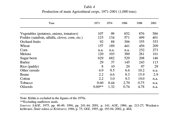
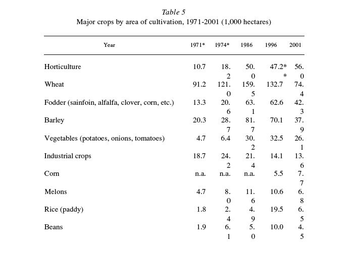
Concomitant with the industrial and social development in the 20th century, the agriculture of the province underwent major changes. Industrial crops saw a rapid growth due to Reza Shah’s policy of reducing the country’s dependence on external supplies of basic products. To provide raw material for the emerging textile factories, the government ordered in 1936 the substitution of cotton in lieu of rice in the mid-course of the Zāyandarud (Lambton). After World War II, sesame and sunflower acreage was extended for oilseed, which have steadily replaced ghee as part of the staple diet. The cultivation of sugar beet was introduced on a wide scale and rapidly became a prime cash crop in Isfahan. These increasingly replaced the cultivation of opium, which was eventually banned by law in the 1960s. During this period, the agriculture of the province was rapidly commercialized in order to satisfy the growing demands of the national market, and primarily those of Tehran, the recipient of a large portion of the fruits and vegetables farmed in Isfahan. The 1970s saw a remarkable expansion of acreage thanks to improvement in water management, as noted above. In that decade, Isfahan saw the introduction of agribusiness (mechanized agriculture), with at least nine large projects in the province (U.S. Department of Commerce, pp. 37-41; cf. Anṣāri, p. 115). The trend came to a halt after the Islamic Revolution, when conditions were no longer favorable to large private investments. On the other hand, the government after the Revolution accorded high priority to the development of agriculture by allocating resources in the form of credit concessions and highly subsidized supplies of fertilizers and machinery. Consequently, in the decade following the Islamic Revolution, there was a marked growth in farm produce ( Table 4 and Table 5). The notable rise in the yield of certain crops may have resulted from growing mechanization and the use of fertilizers and pesticides. The trend toward specialization of agriculture has continued in the last three decades and the province now exports to the national market and abroad. Nonetheless, the rural economy has largely remained traditional, with little mechanization. A characteristic of the land holding system in the province has been the prevalence of smallholdings of many scattered plots in its 2,470 villages (SAOE, 2002, chapter 2). The total average holding has not changed significantly since the Land Reform Law of 1962; it was 3.8 and 3.4 ha in 1964 and 1993, respectively. More than half of the cultivators hold only 6.5 percent of the land, with an average holding of less than half hectare (GEE, 2002, p. 483; Wezārat-e jehād-e kešāvarzi, XIX, p. 55).
Of the 10.7 million hectares surface area of the province, some 600,000 ha are arable. In 2002, 535,000 ha of this was under cultivation or fallow, about half of which (263,000 ha) was under cultivation of irrigated annual crops, while orchards occupied 56,000 ha. The total fallow land was 183,000 ha, 85 percent of which was irrigated cropland. Dry farming (rain-fed crops) constitute some 30,000 ha, less than 6 percent of the total farmland, and is limited to western highlands where wheat and barley are cultivated (GEE, 2002, pp. 459-65). Cereal grains constitute the most important crops in the province; in the case of irrigated crops, nearly half of the land under cultivation was devoted to wheat, barley, and rice; in the case of dry farming, wheat and barley occupy 87 percent of the cultivated area. The chief orchard fruits are apples, grapes, pomegranates, cherries, apricots, pears, plums, quince, and peaches, and of the nuts almonds, walnuts, and pistachios rank highest in terms of cultivated land. Among natural plants gum tragacanth (katirā) has maintained its high importance (Wezārat-e jehād-e kešāvarzi, p. 37; GEE, 2002, p. 487).
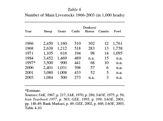
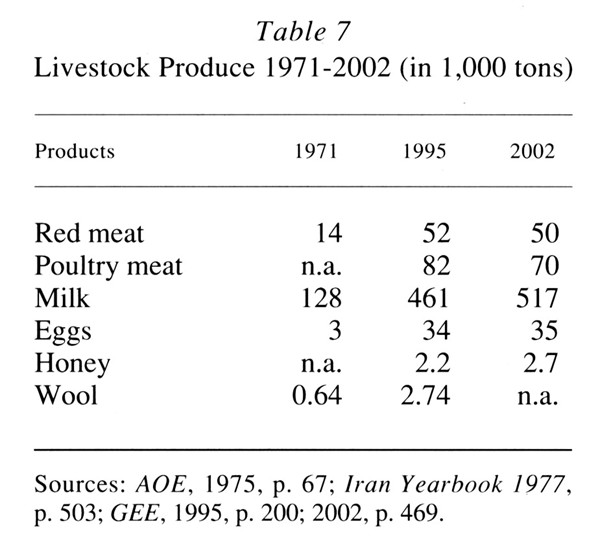
Animal husbandry. Both the villagers and nomads have traditionally kept livestock. Sheep and goats prevail in most of the province while cattle is raised in the upper Zāyandarud valley. The Baḵtiāri tribesmen still summer in, and exploit the rich pastures of, the western highlands of the province, though they are no longer the main suppliers of meat and dairy to Isfahan, having never fully recovered from the devastation they suffered during Reza Shah’s reign, with the loss of about 60 percent of their livestock (see ix above). The villagers feed their domestic animals partly on fodder, but they also rely heavily on natural pastures, which have been diminishing through overgrazing. Drought years have also been responsible for the substantial fluctuation in the number of livestock (Table 6). The expansion of mechanized stockbreeding has been slow and the contemporary proclivity for cattle over sheep has hardly been successful, though selected breeds of cattle have increasingly replaced native ones (GEE, 2002, pp. 468, 483). As for poultry, the progress is more striking (Table 7); scores of mechanized chicken breeding units have been established throughout the province in recent decades. The number of beehives and fish farms has also been growing
Tourism. The existence of numerous historical monuments in Isfahan has made the city a focal point for tourism in the country. The tourist industry was put into motion by the establishment in 1962 of the Organization for Attracting Tourism (Sāzmān-e jalb-e sayyāḥān) that began to train guides and publish maps and brochures for Isfahan. Much was done to encourage tourism by building hotels, by improving roads and air services, and by publicity. A major project was the restoration of a Safavid caravanserai and its conversion into the luxury Shah ʿAbbās Hotel (Borjian, 2002). Isfahan flourished as a hub of tourism in the late 1960s and the 1970s, attracting domestic and international tourists (cf. Ehlers, 1974). The war with Iraq brought the tourist industry to a virtual halt. Subsequently, the Islamic regime tried hard to revive the tourist industry by investing in the rehabilitation of the riverbed and banks of Zāyandarud and the expansion of the parks along the river as well as improvements in the Royal Square. This has proved effective for domestic tourism, especially during the Persian New Year spring break, when scores of holidaymakers head south from the capital. International tourism, however, has never returned to its pre-revolutionary levels. Foreign sightseers are few, mostly from poorer nations of Asia, despite the fairly inexpensive cost of vacationing in Isfahan. This is not surprising given the limitations imposed by Islamic Law coupled with security and safety concerns for foreign travelers.
The tourist infrastructure of the city and province remains underdeveloped. In 1993 there were 26 hotels and 43 guesthouses (mosāferḵāna) in the Isfahan district, with a total of more than 4,500 beds. Among other districts of the province Kāšān had five inns, Fereydan, Golpāyegān, and Šahreżā had three each, Ardestān, Nāʾin, and Ḵᵛānsār had two each, and Naṭanz had one (Sāzmān-e barnāma wa budja, 1997, XV, pp. 42, 69). In 1996, 279,000 tourists visited Isfahan, of which 7.4 percent came from abroad (ibid, p. 62).
Transportation infrastructure. In spite of Isfahan’s central location in Persia, its transportation system has experienced a slow growth and still requires major improvements. The Trans-Iranian Railway, opened in the 1930s, bypassed the province. It was only in 1974, in conjunction with the freight needs of the steel industry, that a line was built to traverse the province some 750 km, extending eastward to meet the Tehran-Kerman line at Yazd (cf. SAK, 1982, p. 610; SAOE, 2001, p. 299). The only airport of the province is in Isfahan.
The most important highway is the Tehran-Isfahan-Shiraz road that traverses the province longitudinally. Constructed in Reza Shah’s reign, following the Safavid caravan route for part of the way, its widening was delayed until recently; yet it remains largely substandard, notwithstanding its significance as a transport artery in the country. This deficiency is partly compensated by a recently completed highway connecting Kāšān to Isfahan, competing with the old Kāšān-Yazd road that bypasses Isfahan. Roadways also connect the city eastward to Yazd and westward to Lorestān, and through the latter Isfahan is ultimately linked with Ḵuzestān. The projected shortcut highway to the latter province through the high Zagros range, planned some years ago, is yet to be realized. The network of countryside roads has, in contrast, improved in the past decades thanks partly to the post-revolutionary efforts of the Rural Development Corps (Jehād-e sāzandegi). In 2002 the province had 78 km of freeways, 1,528 km of major roads, and 2,776 km of minor roads, totaling 4,482 km, with the remarkable growth of 10.7 percent in just one year (Bank-e Markazi, 2004, p. 67 cf. Sāsān, pp. 180-84). In spite of this, the underdeveloped nature of the province’s transportation infrastructure becomes evident in the number of highway bridges longer than 20 m; they tallied no more than 15 in 2001 (SAOE, 2001, p. 303).
Energy infrastructure. For most of the 20th century the production and consumption of energy in Isfahan was quite limited. The electric plant founded by ʿAṭāʾ-al-Molk and Mirzā Fatḥ-Allāh Khan Dehdašti in the early 1930s was supplanted by a larger turbine plant in the 1950s, using diesel fuel to generate electricity for lighting buildings and streets of Isfahan. There were also generator units at individual factories of the city and in a few other towns of the province (FJI, p. 23). The fuel needed for these power plants, as well as for heating, transportation, and industrial consumption, was transported by tankers from refineries in Ḵuzestān and Tehran. To these one may add the traditional supply of coal produced from wood, which ultimately led to the destruction of woodlands after centuries of consumption. Villagers also used watermills to generate mechanical energy.
The situation has altered drastically since the 1970s. A hydroelectric power plant, an oil refinery, and several thermal power plants have been put into production and the newly-built heavy industries have become both suppliers and consumers of energy. Networks of oil and natural gas pipelines and electric transmission lines link the city and the province of Isfahan to other energy producing and consuming areas of Iran. Through these networks Isfahan imports crude oil and natural gas from Ḵuzestān and exports petroleum products and electricity to neighboring provinces. More recently the development of nuclear technology has been in progress, but no serious attempt has been made to harness the immense potentials of solar energy and wind power that exist in abundance throughout the province.
Petroleum. The Isfahan refinery was constructed in the second half of the 1970s by a joint venture of Fluor Iran and the German Thyssen Rheinstahl Technik. Initially designed for a daily output of 200,000 barrels (U.S. Department of Commerce, p. 51), the refinery was expanded in phases, apparently to compensate for the destruction of the Ābādān refinery during the war with Iraq. By 2001 the Isfahan refinery was the largest in the country, producing a quarter of the national output. Its production in 2002 reached 550,000 barrels daily (ca. 20 million m3 annually); it encompasses a wide variety of petroleum products: propane, gasoline, jet fuel, bunker oil, heating oil, diesel oil, lubricants, and asphalt. Only a third of this output is consumed in the province; the surplus is pumped to the Tehran and Tabriz refineries through pipelines. The crude oil comes from Āqājāri in Ḵuzestān via a 435 km pipeline that crosses the Zagros chain at a maximum altitude of 2,700 m. Thus, Isfahan refinery functions as a point of distribution of oil and gasoline for the country and is supplemented by the largest tank farm reserve in Iran (cf. GEE, 2002, p. 417; Baḵtiāri, p. 13; Borjian, 1997; Šerkat-e melli-e naft-e Irān).
Natural gas. The consumption of natural gas has been on the rise in recent decades, increasingly replacing petroleum consumption. In 2002 more than 10.2 km3 was burned in the province, of which 71 percent was consumed by the industrial sector. The heavy industries, including steel, oil-refining, petrochemical, cement, as well as the thermoelectric plants now receive more than 90 percent of their fuel as natural gas. Households make up 26 percent of the consumption, and this has prompted a whole new generation of locally made room heaters for the internal market. A network of pipelines, both steel and polyethylene, distribute natural gas to more than 110 towns and villages in the province (GEE, 2002, p. 434).
Electricity. The chief source of electricity production in the province is thermal energy provided by fossil fuel. Two large power plants generate 80 percent of the total output of 19,000 MWhr (2002 figures). Several more thermal power plants are located in the steel mills and other industrial establishments. The hydroelectric generation capacity of the Shah ʿAbbās dam is only 55 MW, i.e. less than 2 percent of the total electricity output of the province. All these sources feed an integrated network that distributes power among the consumers. Electricity consumption has been growing enormously in the recent past; in 2002 some 4,500 MWhr was consumed in the province. Half of this was used by industry while agriculture and household needs consumed less than a quarter each, and the rest went to general public and commercial use. The surplus production is pumped into the nationwide grid through a system of electricity transmitting towers (GEE, 2002, p. 420).
Nuclear. Isfahan is known to be the primary location of the national nuclear program. It began in 1975 when Persia signed an agreement with France to build a nuclear research center in Isfahan in conjunction with the University of Isfahan. The program was interrupted by the Revolution and lack of further assistance from the West; but new sources of technical know-how emerged after the disintegration of the Soviet Union. A facility associated with the Center was opened with Chinese assistance in the mid-1980s near Isfahan. As a stepping-stone to achieve nuclear technology, a uranium conversion and enrichment plant has been established in the facility. Additionally, a uranium enrichment facility using gas centrifuges is under construction near Naṭanz (for further discussion, see Bahgat, pp. 307-27).
Bibliography
Ḥasan ʿĀbedi, Eṣfahān az leḥāẓ-e ejtemāʿi o eqteṣādi, Tehran, 1955.
Neʿmat-Allāh Akbari, Barrasi-e taḡyirāt-e kammi-e ešteḡāl dar baḵšhā-ye moḵtalef-e eqteṣādi o čašmandāz-e āyanda-ye ān dar ostān-e Eṣfahān (a report), Sāzmān-e modiriyat o barnāmarizi-e ostān-e Eṣfahān, 2003.
Hormoz Anṣāri, Moqaddama-ʾi bar jāmeʿa-šenāsi-e Eṣfahān, ed. Aḥmad Jawāheri, Isfahan, 1990.
ĀOE (Āmār-nāma-ye ostān-e Eṣfahān), Markaz-e āmār-e Irān, Isfahan, annually since 1971.
MansÂur ʿAṭāʾi, “Gozāreš-e eqteṣādi darbāra-ye zerāʿathā-ye ostān-e dahom,” Taḥqiqāt-e eqteṣādi, nos. 9-10, 1964.
Gowdat Bahgat, “Nuclear Proliferation: The Islamic Republic of Iran,” Iranian Studies 39/3, 2006, pp. 307-27.
Ṣādeq Baḵtiāri, Barrasi o taḥlil-e sāḵtār-e ṣanʿat dar ostān-e Eṣfahān o jāygāh-e ān dar eqteṣād-e Irān, Moʾassesa-ye moṭāleʿāt o pažuhešhā-ye bāzargāni, Fayż-Allāh Bakāʾi-Jazi, ed., Gozāreš-e eqteṣādi o ejtemāʿi-e ostān-e Eṣfahān, Edāra-ye koll-e omur-e eqteṣādi o dārāʾi-e ostān-e Eṣfahān, 1977. Tehran, 2003.
Bank-e Markazi, Gozāreš-e awżāʿ-e eqteṣādi o ejtemāʿi-e ostānhā-ye kešvar dar sāl-e 1381, Tehran, 2004.
ʿAli-Reżā BasÂiri, ed., Gozāreš-e awżāʿ-e eqteṣādi-e ostān-e Eṣfahān, Wezārat-e omur-e eqteṣādi o dārāʾi, n.d.
Habib Borjian, “Az kārvānsarā tā mihmān-sarā,” Dāneš–nemā, nos. 84-85, 2002, pp. 39-44.
Houri Borjian, ed., Eṣfahān šahr-e ṣanʿat o honar, Tehran, 1997.
Jean-Claude Codonnier, “Les tendances nouvelles de l’agriculture irriguée dans l’oasis d’Isfahan,” Révue Géographique de l’Est 4, 1964, pp. 387-92.
Edāra-ye āmār-e ʿomumi, Āmār dar Irān, 1/1, Jan. 1960.
E. Ehlers, “Some geographic and socio-economic aspects of tourism in Iran,” Orient 15, 1974, pp. 97-105.
Eskandar Beg Torkamān Monši, Tāriḵ-e ʿĀlamārā-ye ʿAbbāsi, ed. Iraj Afšār, 2 vols., Tehran, 1955-56.
Paridokht Fesharaki, “L’oasis d’Isfahan,” Doctoral diss., Univ. de Paris-Sorbonne, 1967.
FJI (Farhang-e joghrā-fiāyi-e Irān, ābādihā, X, Tehran, 1950, repr. 1976.
GEE (Gozāreš-e eqteṣādi-ejtemāʿi-e ostān-e Eṣfahān), Sāzmān-e barnāma wa budja-ye ostān-e Eṣfahān, annual report from 1995-2002.
M. Hartl, Das Najafabadtal. Geographische Untersuching einer Kanatlandschaft im Zagrosgebrige (Iran), Regensburger Geographische Schriften 12, Regensburg, 1979.
Bernard Hourcade et al., Atlas de l’Iran, Montpellier-Paris, 1998.
Iran Yearbook 1977, Kayhan Research Associates, 1977.
ʿAli Jawāherkalām, Joḡrāfiā-ye tāriḵi-e Eṣfahān o Jolfā, Tehran, 1969.
Ann K. S. Lambton, “The regulation of the waters of the Zāyande Rūd,” BSOAS 9/3, 1937-39, pp. 663-73.
Moḥammad Maḥmudiān, Zāyandarud-e Eṣfahān, Isfahan, 1969.
Markaz-e āmār-e Irān, Natāyej-e āmārgiri az kārgāhhā-ye ṣanʿati-e kešvar, Tehran, 1997.
C. Millspaugh, The American Task in Persia, New York, 1925.
Xavier de Planhol, “L’oasis d’Isfahan d’après P. Fesharaki,” Revue Géographique de l’Est 9, 1969, pp. 391-96.
Moḥsen Renāni et al., Gozāreš-e nehāyi-e ṭarḥ-e pažuheši: Barrasi-e sāḵtār-e ešteḡlāl dar baḵš-e ḡayr-e rasmi-e ostān-e Eṣfahān (report), Sāzmān-e modiriyat o barnāmarizi-e ostān-e Eṣfahān, 2004.
Sirus Šafaqi, Joḡrāfiā-ye Eṣfaḥān, Isfahan, 1974.
SAK (Sāl-nāma-ye āmāri-e kešvar), Markaz-e āmār-e Irān, various years. SAOE (Sāl-nāma-ye āmāri-e ostān-e Eṣfahān [substituted Āmār-nāma-ye ostān-e Eṣfahān]), Markaz-e āmār-e Irān, annual report, 1975-2003.
ʿAbd-al-Ḥosayn Sāsān, Eqteṣād-e jābajāgari o pažuheši dar rāhhā-ye ostān-e Eṣfahān, Tehran, 1985.
Sāzmān-e barnāma wa budja-ye ostān-e Eṣfahān, Barnāma-ye ʿomrāni-e ostān-e Eṣfahān, reports from 1973 to 1991.
Idem, Moṭāleʿāt-e tawseʿa-ye eqteṣādi, ejtemāʿi o farhangi-e ostān-e Eṣfahān, 2nd ed., 27 vols., 1997.
Šerkat-e melli-e naft-e Irān, Pālāyešgāh-e Eṣfahān, Tehran, 1992.
Brian Spooner, “City and river in Iran: Urbanization and irrigation of the Iranian Plateau,” Iranian Studies 7, 1974, pp. 681-713.
Šurā-ye ʿāli-e barnāmarizi-e ostān-e Eṣfahān, Gozāreš-e ʿamalkard-e goẕašta wa ważʿ-e mawjud-e baḵšhā-ye eqteṣādi, ejtemāʿi o farhangi-e ostān-e Eṣfahān, 2 vols., Isfahan, 1983-84.
Mirzā Ḥosayn Khan Taḥwildār, Joḡrāfiā-ye Eṣfahān, ed. M. Sotuda, Tehran, 1963.
Aṣḡar Ṭalā-mināʾi, Taḥlil-i az vižagihā-ye manṭaqaʾi dar Irān bar asās-e manṭaqa-ye nemuna-ye Eṣfahān, Tehran, 1974.
U. S. Department of Commerce, Iran: Country Market Sectoral Survey (A survey of U.S. Business Opportunities), Washington, D.C., 1977.
Wezārat-e jehād-e kešāvarzi Moṭāleʿāt-e santez-e ostāni-e tarḥ-e jāmeʿ-e tawseʿa-ye kešāvarzi, Mohandesin-e mošāver-e Jāmeʿ-e Irān, 19 vols., Tehran, 2001.
Wezārat-e Kešāvarzi, Āmār-nāma-ye Kešāvarzi, 1986.
Idem, Moṭāleʿāt-e jāmeʿ-e eḥyāʾ o tawseʿa-ye kešāvarzi o manābeʿ-e ṭabiʿi-e ḥawżahā-ye ābḵiz-e rudḵānahā-ye Zāyandarud o Ardestān, a report prepared by Mohandesin-e mošāver-e yekom, Tehran, 1997.
H. E. Wulff, The Traditional Crafts of Persia: Their Development, Technology, and Influence on Eastern and Western Civilizations, Cambridge, Mass., 1966.