

GILĀN
xi. IRRIGATION
In the Caspian region of Iran, abundantly watered by rivers descending from the mountains, irrigation methods differ significantly from the techniques and methods used in the country’s arid zones, characterized by their use of subterranean aqueducts (qanāts). In the rice-growing regions of the Caspian hinterland, water requirements are considerable and irrigation requires careful organization. It is estimated that one hectare of rice requires from 9,000 cubic meters in the Fumanāt region (Bazin, I, p. 115), to 18,000 cubic meters of water, with the average being 12,400 cubic meters (Sogreah-Cotha, p. 28). The flooding of rice terraces alone at the beginning of the crop cycle accounts for 2,700 cubic meters per hectare (Sahami, p. 73).
To meet this demand various techniques are used, depending on the micro climate of the area and the resources available. Local springs are used in the upstream valleys, as well as rain water, but this is not sufficient by itself. Reservoir pools (sal in Gilaki and Tāleši; estaḵr in Persian), which receive watershed runoff in addition to rain water, and occasionally water from drainage ditches, also contribute to the irrigation system, as well as streams and mountain rivulets channeled via makeshift dams (mountain runoff, however, is usually quite cold and not conducive to germination beside the fact that water flows tend to be extremely variable and minimal from early June). The water from the Sefidrud is also channeled and subdivided into multiple small ducts to irrigate the lands of the central plain. To improve irrigation, an immense storage dam 425 m long by 110 m high (originally with a capacity of 760 million cubic meters, see Pluquellec, p. 98), was built in 1962 by the French company Sogreah-Cotha, downstream from the confluence of Qezel Ozon (the Turkish name for Sefidrud upriver from Gilān) and Šāhrud river in Manjil. It may appear paradoxical that such a large irrigation project should be necessary for one of the wettest regions of Iran, but this can be explained by the fact that Gilān, together with Māzandarān, are the principal growing regions for rice, a staple food of the country. Downstream from this large reservoir, two weirs were constructed on the Sefidrud: one at Tarik, to provide water to the Fumanāt (see FUMAN) via a 17 km underground canal; and the other at Sangar, to complete irrigation of the left bank including the Rasht (Rašt) region, and to ensure a regulated flow of irrigation water to lands on the right bank of the Sefidrud. These dams replaced the makeshift weir dams built on the Sefidrud to channel water in the riverbed. The original, makeshift structures consisted of tetrahedra constructed of wood with interleaved branches (see diagram and photos in Rabino and Lafont, 1911, p. 7; Sogreah-Cotha, plate illustration, and Sahami, plate illustration). From a main canal, diverted from a riverbed or from the Sefidrud to the ditches (lāju), which irrigate neighboring fields, there follow a succession of secondary, tertiary and even quaternary canals (nahr: ‘stream,’ or šāḵa :’branch,’, or in Taleši ḵola). Before every irrigation season, the derivation canal (dahana) that directs water to a village or a farmer’s fields must be scoured and maintained. Meanwhile the drainage water is channeled through canals known as qanu or bijārbin and used for irrigation of lands further down.
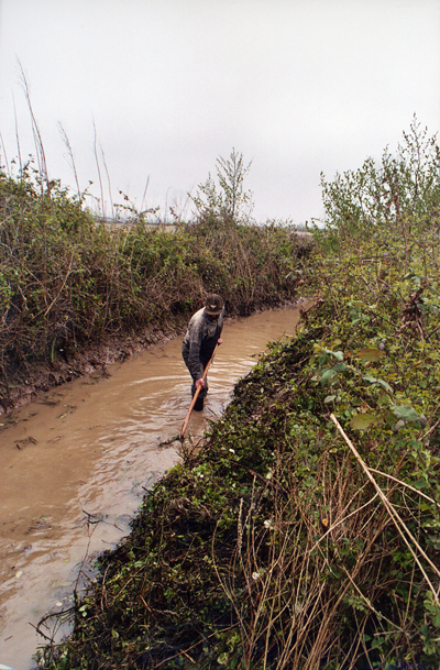
From the water source to the irrigation canal, before each irrigation season (from April to August), it is necessary to organize the maintenance of the canals, clean and scour the conduits (nahr-kani) and eventually set water allotments (nawbat) and ensure equity among property holders in the event of insufficient water flow. At a higher level, that is with respect to the river source and the main canals, maintenance and water allotments must also be addressed. In the past, prior to the Land Reforms of the 1960s (see AGRICULTURE), these tasks were the responsibility of the large landowners. Since 1963, the communal irrigation authority (Sāzmān-e ābyāri) selects a sar mirāb (“Chief water master”) or mirāb-e kolli (“General water master”) who oversees several jub-sālārs, each assisted by two to five mirābs or ābyār-šāgerds (“assistant irrigators”) whose job it is to ensure the fair distribution of water among the different villages (Bazin, I, p. 118; Rabino and Lafont, 1911, p. 8). At a more local level, that is, at the level of the hamlet (maḥalla), a basic social unit in Gilāni society (Bromberger, pp. 34-38), one or more mirābs (miro in Gilaki) or ostād-e ābāvar-e maḥalli (“local irrigation master”) are elected by the villagers at the beginning of each year, the elections taking place at the mosque or bazaar. These officers oversee the smooth functioning of the work teams (iljār, bigār, biqār), including: construction or rehabilitation of dams on the Sefidrud by men drafted for the task among village property holders (a widespread practice in the past), redeployment of main canals according to water requirements, and the cleaning and scouring of local canals. The day following the sizdah bedar (i.e. 13 Farvardin/2 April), the miro summons the local farmers to the sound of a horn (frequently a cattle horn) to complete the work. Each property holder must clean a length of canal proportional to the size of his rice field (FIGURE 1). The unit of measure for the chore, equivalent to one jerib, (about one hectare in the central plain, see Bazin and Bromberger, p. 54 and map 30) of the cultivated surface area, is the toqs, a measure that ranges in length from 30 to 50 meters and is determined by the miro with respect to the terrain’s difficulty. Penalties are meted out to those who fail in their communal obligations; at one time offenders were tied to a tree and lashed with a pomegranate branch, now they are referred to the local Islamic Council (šowrā-ye eslāmi), which adjudicates such disputes. Compensation for the miro, whether in cash or in sheaves of rice (darz), is apportioned according to the acreage owned. At the beginning of the 21st century, compensation varied from two to six darz of good quality rice per jerib according to the work difficulty encountered by the “Chief water master.” Farmers must also pay a water tax proportional to the area cultivated.
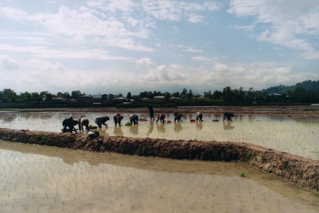
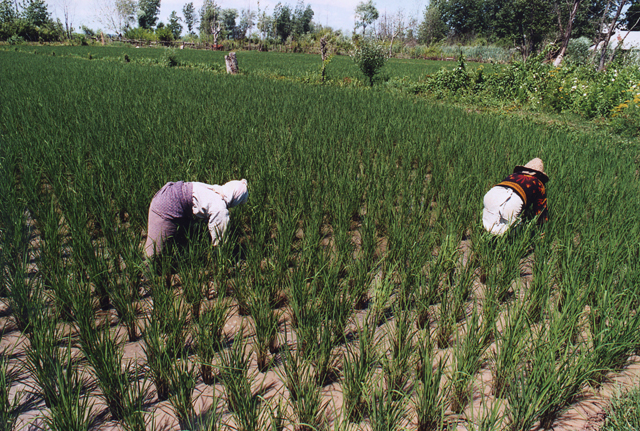
Irrigation being gravitational, water flows from one plot (kalla) to another through narrow gaps (biege) dug in the dikes (marz) with a long shovel (bil-e ābyāri, čelāru, ḵelik, gerbāz) unless it comes directly from the canal (lāju). The depth of water required varies with the cultivation task effectuated in the paddy and on plant growth. Water must be at least two centimeters above ground during plowing and harrowing (piškāvol, lat) and one centimeter at transplanting (nešā; FIGURE 2a, FIGURE 2b). After transplanting, “one does not water for three days while the roots take hold, only then does one flood the field leaving only the tops of the plants out of the water. From that time the rice should remain covered with water” (Rabino and Lafont, 1910, p. 163). The thickness of water reaches as much as ten centimeters over the course of plant growth (Bazin, I, p. 135; FIGURE 3), but one takes care to drain the rice fields during weeding (vijin, dobāra; FIGURE 4) after which an average of three further irrigations are undertaken, “up to a final flooding, if possible, at the moment of inflorescence. The water supply is cut off once the panicle is properly formed, so as to allow the ground firm up over the last three weeks prior to harvest” (ibid. p. 137).
As storage for catchment rain water, run-off and drainage water, reservoirs (sal) play an important role in the irrigation and in social and economic institutions: they provide an essential complement of water in case of water shortages and may, at times, be the main, if not sole source of water. While they are shallow, their surface area may be considerable. “Their shallow depth limits their capacity despite their extensive surface development,” according to the Sogreah-Cotha report (p. 19), submitted in 1963. “Practically speaking,” it continues, “we found that on average one hectare of reservoir ensured the minimum supply for one hectare of paddy fields during critical periods.”
As mentioned before, prior to the Land Reforms of the 1960s, the construction and maintenance of reservoirs were the responsibility of the large landowners, while the maintenance of the canals and ditches of the distribution system was the responsibility of the growers (Rabino and Lafont, 1911, p. 6). After the Land Reforms, all maintenance tasks fall to the growers under the leadership of the miro. The sal are surrounded by a set of two dikes: the first and highest, the salkul, followed by the labband, which is lower. When one wants to use sal water to irrigate rice fields, gaps are made successively in the salkul and the labband. In the 1980s, through government initiative and aided by bulldozers, the capacity of the communal reservoirs was expanded. At the same time private and cooperative reservoirs were increased at private expense (for the Ḵortum example, see Allaverdian, p. 39). In the 1990s, new branches of the Manjil dam contributed to improve local irrigation (for Ḵortum, see ibid, p. 41), even though water inflows remain irregular and inadequate because of the growing demands of rice culture, the development of aquaculture in the region and the flawed design of existing diversionary dams. The sal not only contribute to irrigation, but provide primary organic materials such as reeds (ney) and bulrushes (li) used for weaving mats (ḥaṣir-bāfi), for basketry (the manufacture of baskets and hats, for example) or the making of fences (parda). In order to cut organic materials however, one must first seek authorization from the miro. The sal are also areas where the numerous species of migratory birds of the Caspian shore may be hunted. And finally, the sal constitute a reserve of arable land. This communal space is, therefore, one of the only if not the only space in rural Gilān, where there a strong collective vigilance is exercised. Attempts at privatization are subject to conflict and encounter peasant resistance. If ever, in this region dominated by a spirit of agrarian individualism (see Bromberger, p. 21), there were a subject for cooperative relations and community interests, it would surely be in the management of water resources.
Bibliography:
C. Allaverdian, “Diagnostic agraire de la région de Xorthum-Chomachah au Gilân en Iran: l’évolution des pratiques agricoles au Gilân de l’époque féodale à la crise du thé,” diss., Cnearc (Centre national d’études agronomique des régions chaudes), Montpellier, 2004.
M. Bazin, Le Tâlech. Une région ethnique au nord de l’Iran, 2 vols., Paris, 1980.
Idem and C. Bromberger, Gilân et Âzarbâyjân oriental. Cartes et documents ethnographiques, Paris, 1982.
C. Bromberger, Habitat, Architecture and Rural Society in the Gilân Plain (Northern Iran), Bonn, 1989.
H. Plusquellec, “Guilan, a successful irrigation project in Iran,” Irrigation and Drainage Systems 10, 1996, pp. 95-107.
H.-L. Rabino and D.-F. Lafont, “La culture du riz au Guilân (Perse) et dans les autres provinces du sud de la Caspienne,” Annales de l’École nationale d’agriculture de Montpellier, X, 1910, pp. 130-64; XI, 1911, pp. 5-51.
C. Sahami, Le Guilân, Paris, 1965.
SOGREAH-COTHA, Réseau du barrage du Sefidroud, mise en valeur de la plaine du Guilân, Tehran, Report to the Plan Organization, 1963.
T. Suzuki, Land Reform, Technology and Small-Scale Farming: The Ecology and Economy of Gilaki-Rashti Rice Cultivators, Northern Iran, Ann Arbor, Mich., 1985.
(Christian Bromberger)
Originally Published: January 1, 2000
Last Updated: July 15, 2009