

ARAXES (ARAS) RIVER.
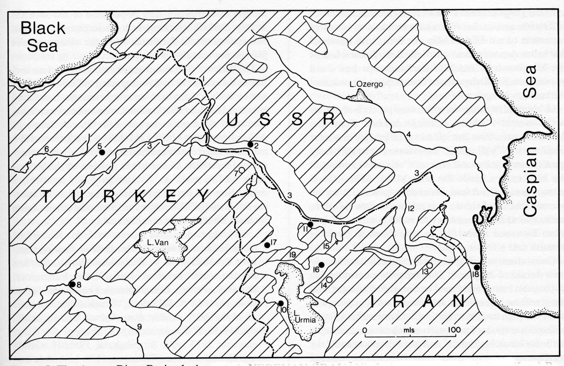
The Araxes river (Figure 5) forms the international boundary between northwest Iran and the USSR from a point east of Mount Ararat (which lies very close to the river) for some 250 miles to Tāzakendīm on the western edge of the Moḡān steppe area. From here eastward the river is entirely within Soviet territory, where it is joined by a major tributary, the River Kor, that rises in the highlands of the Caucasus. The joint river then bends southeast across the Moḡān steppelands and marshlands to reach the Caspian Sea through a small delta that is prolonged into the Caspian by a number of plits. Because of the shifting nature of the lower delta (a common feature) there is no large town at the mouth.
The Araxes rises near Erzurum (Turkey) in the Bingöl Dağ region: there is only a low divide separating it from the headwaters of the Euphrates river. The drainage-pattern of the Araxes is complex. Subsidiary downthrow basins open off it, and a system of feeder tributaries occupying broad, flat-floored valleys has developed. It is joined by numerous tributaries from both north (USSR) and south (Iran). In its upper reaches, the Arpa tributary forms a frontier between Turkey and the USSR. Right-bank affluents in Azarbaijan include the Qotūr Čāy, which drains the Ḵoy basin, the Sare-sū, Mākū Čāy, Anas Čāy, Kurra-art, Sumus Čāy, and the important Qara-sū (see below).
The Aras has a total length of 1,072 km and a drainage area of 102,000 km2 , most of which is situated in the Soviet Union and in Iran; less than 10,000 km2 belong to Turkey. The average annual runoff of the Aras is measured at 210 m3 per second, close to its junction with the Kor. Due to the climatic conditions of eastern Turkey and in the drainage areas of its tributaries the average runoff pattern shows a distinct seasonality. The peak of the river discharge occurs in April and May as a result of snow melting in the mountains; the lowest discharge is recorded during August and September. The watershed is defined by hill ranges that reach 10,000 feet or more in maximum altitude. The Mašu Dağ is one of these ranges, narrow but high, separating the Araxes basin from the closed basin of the Urmia lake sump. This range extends some forty miles until it is interrupted to the east by a col or divide running between Marand and Sufīān now occupied by the road and railway between Tabrīz and Julfa. The watershed continues through the highlands of the Qara Dağ, which run in a crescent-like form for a hundred miles or so farther east, diverting the general course of the Aras from a southeasterly direction towards the northeast. This range then dies down at the valley marking the entry of the Qara-sū. Beyond are spurs of the Ṭāleš hills, fronting the Caspian littoral. The basin of the Qara-sū between the Ṭāleš and Qara Dağ ranges is an extensive lowland, with a heavy, partly volcanic soil that is easily erodable (hence Qara-sū, “Blackwater”); it contains the town of Ardabīl. To the geographer the Qara-sū basin offers an example of obsequent drainage; i.e., streams run west and north from the inner Ṭāleš slopes, at first away from the Caspian, which they later reach via the Araxes.
The northwestern Zagros, of which the Araxes basin forms a major part, comprises a series of massive rock structures chiefly Upper Cretaceous, Miocene, and Plio-Pleistocene in geological age. These have been subject to differential warping and the local rise of volcanic magma; the volcanic complex of Savalān is the largest of these. Folding has also occurred, but on a reduced scale. Overall, topography is made up of a series of detached tablelands or ridges lying at five to six thousand feet elevation, with a number of small detached blocks. Towards the west and north (Turkey and Russia) altitudes are greater, and the plateau surfaces are tilted in a southeasterly direction, to produce an effect of stair-like topography, broken by downthrow basins and fault-defined valleys. Largest of these is the Araxes itself, which consists throughout its length, other than in its lowest (Russian) portion over the Moḡān steppe, of a sequence of fault-troughs later joined by stream erosion to form a single continuous valley. General pattern is thus one of alternate narrow, even gorge-like, sections opening out into broader sections up to 40 miles in width, with expanses of flat lowland. There is a well-developed gorge section near Julfa. Intensive erosion of the surrounding highlands in earlier (Tertiary and Quaternary) geological time has brought down much rock debris—some silts and clays, but more often rock fragments of varied size that are deposited in extensive sheets over flatter areas.
In the gorge sections rock series of various ages back to Triassic and Carboniferous are visible with extensive exposures of red Middle Miocene beds, with interbedded saline deposits. Because of the wide distribution of the Miocene beds much of the landscape has a red appearance. Small deposits of coal (Upper Jurassic and Purbackian in age) are found.
In classical writing the river was proverbial for its swift current “whose rushing descent from the Armenian mountain carried away the bridges in winter time” so that Virgil calls it “the stream intolerant of any span (pontem indignatus Araxes).” Kinnier, writing in the last century, made the same point: “The river is extremely rapid, but fordable in many places during the summer. At Nuckshivan it is not more than 60 yards wide, and at Megree, about 55 miles north of Tabriz when I crossed it in 1810, it was about 80 yards in breadth and 4 feet in depth.”
Cultivation in the valley generally is possible only with the aid of irrigation. This supports a considerable population living in grouped and scattered villages; and the greenness of the fields, and the orchards, poplars and willows which line the irrigation ditches give the villages of the valley an air of prosperity which contrasts sharply with the bleak highlands, and semi-desert around the Moḡān steppe, which can only be used as seasonal grazing ground for animals. While the Aras usually is not navigable due to great annual variation in runoff and its many fords and shallows, it is an important source of hydroelectric power and irrigation development. Unlike the Russians, who started irrigation schemes along the Kor and Araxes as early as the 19th century (partly as a restoration of ancient irrigation networks; see the article Azarbaijan), the Iranian government did not develop any water resources until after World War II. Two small irrigation canals were built in 1951 near the junction of the Qara-sū with the Araxes, irrigating an area of approximately 22,000 ha, and the bilateral Iranian-Soviet agreement of 1963 led to joint development of the Aras for hydroelectric power generation and large-scale irrigation systems. In 1971 a first barrage to regulate the runoff of the Aras was finished near the Iranian village of Qezel Qešlāq (close to the Soviet city of Nakhichevan/Naḵǰavān), creating a lake of 145 km2 in size with a storage capacity of 1.35 billion m3. In 1972 a second barrage was finished (Aṣlāndūz barrage) close to the junction of the Araxes and Qara-sū, providing equal shares of irrigation water (80 m3 per second) for agricultural development on the Soviet and the Iranian sides of the Dašt-e Moḡān. The “Aras-Moḡān Development Scheme” (Schweitzer, 1973) is the largest of its kind in northwest Iran, it has created 150 million kWh of hydroelectric energy and more than 60,000 hectares of newly irrigated lands.
The main settlements of the valley are Julfa, Makū, Marand, and Ardabīl. Except for Julfa, which is a communication, road, and rail center, they act mainly as markets for the produce of the area-principally tobacco, cotton, opium, cereals, and dried fruits. Transport by river of locally produced goods began in 1968 with the use of two boats. The population of the valley is mostly Turkish-speaking and predominantly settled, but semi-nomadic shepherds from the village use the plateau for seasonal grazing.
The treaty of friendship negotiated between Iran and Soviet Russia in 1921, while declaring null and void “the whole body of treaties and conventions concluded between Iran and the Tsarist Government,” explicitly confirmed the frontier terms of the Tsarist Treaty of Akhal Khorassan (1299-1311/1881-93) which had demarcated the frontier much in Russia’s favor by including in the USSR all the lower portion of the Araxes basin as far south as Āstārā. In 1928, however, a convention was signed governing the problem of crossing the Iran-USSR frontier for those inhabitants living within a 40-mile zone on either side.
Bibliography
See indexes in J. M. Kinnier, A Geographical Memoir of the Persian Empire, repr. New York, 1973.
A. V. W. Jackson, Persia, Past and Present, repr. London, 1966.
Naval Intelligence, Division, Persia, Geographical Handbook Series, London, 1945.
A. Roosevelt, “The Kurdish Republic of Mahabad,” Middle East Journal 3, July, 1947, pp. 247-69.
F. Kazemzadeh, The Struggle for Transcaucasia 1917-1921, Birmingham, 1951.
H. Gehrte and H. Mehner, Iran, Tübingen, 1975.
L. A. Adamec, Historical Gazetteer of Iran: Tehran and Northwestern Iran, Graz, 1977.
Camb. Hist. Iran I, index, p. 768.
L. W. Alexander, “Iran-USSR Boundary,” International Boundary Studies 25, Department of State, Washington. G. Schweizer, Nordost-Azerbaidschan und Shah-Sevan-Nomaden. Strukturwandlungen im nomadisch-bäuerlichen Lebensraum des Orients, Erdkundliches Wissen, Heft 26 (Beihefte zur Geographischen Zeitschrift), Wiesbaden, 1970, pp. 81-148.
Idem, “Das Aras-Moghan-Entwicklungsprojekt in Nordwestiran und die Probleme der Nomadensiedlung,” Zeitschrift für Ausländische Landwirtschaft, 1973, pp. 60-75.
Idem, Untersuchungen zur Physiogeographie von Ostanatolien und Nordwestiran. Geomorphologische, klima- und hydrogeographische Studien im Vansee- und Rezaiyehsee-Gebiet, Tübinger Geographische Studien 60, Tübingen, 1975.
(W. B. Fisher)
Herodotus (1.202) reports the Araxes as rising in the country of the Matieni, i.e., in Azarbaijan, but seems to consider it as lying to the east of the Caspian, before the lands of the Massagetae of the Inner Asian steppes; and Xenophon and the Ten Thousand identified the upper reaches of the river with the Phasis, flowing westward into the Caspian Sea (the modern Rion river). The early Greek sources were thus hazy about the Araxes and its position, but Strabo and Pliny placed it more accurately, being aware of the small islands at its mouth, while Ptolemy noted along its course the towns of Armavir, Artašat, and Naḵǰavān (Nakhichevan) (see Tomaschek in Pauly-Wissowa, II/1, cols. 402-04, and E. Dieh in XIX/2, cols. 1886ff.). In Armenian sources we find the river’s name mentioned as Eraskʿ, and in Georgian ones as Raḵšī. Control of the valley was contested by the Sasanians and the Byzantines. In 363 A.D. a peace treaty restored Armenia (including the Araxes) to Persia, but increasing Byzantine pressures in Armenia and elsewhere gradually led to increasing border attacks between the two empires. Eventually the Byzantines under the emperor Heraclius used the Araxes valley as the route for a large scale irruption into Azarbaijan. In Islamic times, the Araxes became known in Arabic parlance as al-Rass, and in Perso-Turkish contexts as Aras (in the Ḥodūd al-ʿālam, tr. Minorsky, vocalized as Aros). This Arabic name led the Muslim exegetes to connect the Araxes with the Aṣḥāb al-Rass of Koran 25:38, 50:12, mentioned along with ʿĀd, Ṯamūd and other unbelievers as a people destroyed for its impiety (see A. J. Wensinck, EI2 , s.v. “Aṣḥāb al-Rass”), and popular belief came also to connect the peoples of the Araxes valley villages with the host of Goliath killed by David and to locate Goliath’s tomb at Urmia (cf. Abū Dolaf Mesʿar b. Mohalhel al-Ḵazraǰī, Second resāla, ed. and tr. Minorsky, Cairo, 1955, par. 16, tr. p. 36, also given in Yāqūt, Moʿǰam al-boldān, Beirut, 1374-76/1955-57, III, p. 44).
The middle and eastern parts of the Araxes basin passed under Arab control when the Muslims pushed northwards from Azarbaijan towards the eastern Caucasus in the late 1st/7th century, but for several centuries to come, it remained in many ways a frontier area. The Armenian Christian princes straddled its middle and upper reaches, and beyond them were the Byzantines, with their great base at Erzurum (Arzan al-Rūm). It was also vulnerable, as a populous and fertile valley area—Abū Dolaf, loc. cit., enthuses over its pomegranates, olives and grapes—to attacks in the early centuries from the Turkish Khazars from north of the Caucasus and from Caucasian peoples like the Alans or Ossetes. Hence the caliphs, realizing the difficulties of attempting to exercise direct political rule, tended to leave the governors of Azarbaijan and Armenia to make local arrangements with the Armenian lords of Kapan, Siunikʿ, Vaspurakan, etc., provided that some sort of loose vassalage was acknowledged, and with the Kurdish and Iranian princes of the eastern parts of the region. In any event, there were frequent disturbances in the region because of invasions from the Khazars, Alans, and Rūs from the north, from squabbles between these local potentates and, in the first half of the 3rd/9th century, by such movements of religio-social protest as Bābak’s Ḵorramīya, the epicenter of whose uprising was at Baḏḏ (Bazz) in northern Azarbaijan just south of the lower Araxes.
During all this period, the Araxes valley remained an important highway for international trade arriving from across the Caspian and through northern Iran and being conveyed to the Byzantine lands and the Black Sea ports like Trebizond. Hence the Armenian centers of Julfa, Dvin (Arabic Dabīl ) and Ani (Arabic Ānī flourished exceedingly, with commercial wealth at Ani, for instance, being expended on magnificent churches by the Armenian Bagratids and on mosques and public buildings by the Muslim Shaddadids who controlled it after the Saljuq Alp Arslān’s conquest of the town from the Greeks in 465/1072. It was partly to facilitate trade, and partly to convey troops across the river into Azarbaijan as a part of expansion plans, that the Kurd Fażl or Fażlūn (Armenian Pʿaṭʿlun) b. Moḥammad b. Šaddād of Ganja built a bridge over the Araxes in 421/1030, probably at Ḵodāfarīn connecting Qara Bāḡ to the north with Qaraǰa Dāḡ in Azarbaijan. Certainly, the whole Araxes valley and the towns along it—Baǰarvān in Moḡān, Ordūbād, and Julfa on the southern bend of the river, and the Armenian center of Naḵǰavān, Dvin, Erivan, Ani, and Avnīk in the upper reaches of the valley—saw much fighting in the medieval period. The whole valley was used as a corridor for the migrations from the 5th/11th century onwards of Turkmens heading for eastern Anatolia once the Byzantine defenses there had crumbled after the battle of Manzikert or Malāzgerd (464/1071). Subsequently it came under the control of Turkmen dynasties like the Āq Qoyunlū and Qara Qoyunlū and then of local khanates like those of Qara Bāḡ and Naḵǰavān which formed a buffer region between the Ottomans and Safavids. In the 19th century, the Persians were obliged to relinquish suzerainty over the Turkish khanates north of the Araxes in face of the imperialist policies of Russia, and after the Golestān Treaty of 1228/1813 and the definitive Treaty of Torkamaṇčāy of 1244/1828, the middle stretch of the river came to form the boundary between Qajar Persia and the Tsarist empire.
See also Le Strange, pp. 166-68.
E. Honigmann, Die Ostgrenze des byzantinischen Reiches von 363 bis 1071 nach griechischen, arabischen, syrischen und armenischen Quellen, Brussels, 1935, index.
V. Minorsky, Studies in Caucasian History, London, 1953, pp. 44-45, 104ff., and index.