

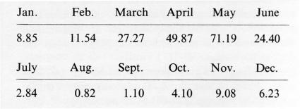
ĀJĪ ČĀY (Talḵa-rūd, “Bitter river”), a river some 200 km in length which rises on the western flank of Kūh-e Sabalān near Sarāb and flows into Lake Urmia (Reżāʾīya) near the town of Gogān. In its upper and middle reaches, east of Tabrīz, numerous small tributaries from Qowšādāḡ to the north and Bozḡūš and Kūh-e Sahand to the south flow into it. Due to the mountain origins of many of its source rivers and tributaries, the flow of the river shows marked seasonal variations, peaking in April and May because of melting snow. The station at Vanyār above Tabrīz, where the river has a catchment area of 8,100 sq km, recorded for the mean of the period 1961-62 to 1971-72 average monthly flow figures (in cbm/sec) as shown in Table 1.
The average yearly figure was 18.65.
The Āǰī Čāy curves past Tabrīz some three km to the north, enters its lower course, and flows into the alluvial plain around Lake Urmia. Particularly in the spring (March, April, May) serious flooding often occurs, and extensive marsh lands are formed. The river water contains dissolved salts, especially from the tributaries which flow through the Miocene clays and marl northeast of Tabrīz; and salts and other minerals are thus deposited in the lower course. This high salt content explains the river’s name. The salt concentration and the marshy conditions make farming impossible in the alluvial plain around Lake Urmia except in a few dry locations. There are many years when, apart from the regular drying up of the river in summer, the river fails to reach the lake proper but instead seeps away and evaporates in the marshes along the shore.
The upper reaches of the Āǰī Čāy command the largest catchment area of all the tributaries of Lake Urmia excepting the Zarrīna-rūd. These are not salty and therefore lend themselves to agricultural use. Until it reaches Tabrīz, the river supplies water for irrigation purposes; this function is then taken over by qanāts. Since the seasonal yield of the fresh-water qanāt reveals analogies with the river flow, we must assume that the underground water of the Āǰī Čāy basin is fed by the river but that the salts are trapped in the soil.
Bibliography:
G. Schweizer, Untersuchungen zur Physiogeographie von Ostanatolien und Nordwestiran. Geomorphologische, klima- und hydrogeographische Studien im Van- und Rezaiyehsee-Gebiet (Tübinger Geographische Studien 60, 1975).
Kayhān, Joḡrāfīā I, p. 82.
(E. Ehlers)
Originally Published: December 15, 1984
Last Updated: July 29, 2011
This article is available in print.
Vol. I, Fasc. 7, pp. 701-702
E. Ehlers, “ĀJĪ ČĀY,” Encyclopædia Iranica, I/7, pp. 701-702; an updated version is available online at http://www.iranicaonline.org/articles/aji-cay-river-which-flows-into-lake-urumia (accessed on 25 April 2014).