

RAY
i. ARCHEOLOGY
The first Western accounts of Ray (Rayy) were produced by British travelers such as Sir James Morier (pp. 231, 403) and Sir William Ouseley (pp. 174-99), who visited Ray between the 1810s and 1830s. These descriptions of the city were not informed by an archeological approach, but rather bore a nostalgic accent, recalling its glorious past.
It was only in the first half of the 19th century that Ray became the object of a more comprehensive study. Robert Ker Porter (1777-1842) drew the first plan of old Ray, enclosed by a strong rampart (1821-22, pp. 358-60). This plan, although inaccurate, has been the only plan used in all publications until the present day. Its orientation is wrong and the major water source, that of Čašma-ye ʿAli, is misidentified. Some years later, in 1840, another traveler, the French architect Pascal Coste (1809-1889; see FLANDIN AND COSTE), visited Ray. The latter drew a more precise plan of the old city (see Rante, 2007, fig. 7). In addition, he drew some views of the site (unpublished, located in the Départment Patrimoine: Fonds Rares et Précieux et Documentation Régionale of the Alcazar Library, Marseille), from the Bibi Šahrbānu mountain, a few meters to the east. All the different water sources are noted, and the orientation respects the actual placement of the city; he indentified the different parts of the city, and showed the three different ramparts, relating to the different periods of the city.
Over a period of several years in the late 19th and early 20th century, the site was excavated unscientifically by Western archeologists and local dealers, above all to search for precious objects; a large proportion of the finds found their way to the black market. At present several museums conserve some specimens from Ray belonging to this antiquarian surge (for example, at the Louvre Museum there is a group of pottery fragments belonging to the Charles Kiefer collection and an object belonging to the Vignier excavation, 1921, OA 7474). George Nathaniel Curzon, after his journey into Persia (published in 1892) at the end of the 19th century, wrote: “I am not aware that any scientific or systematic excavation has ever taken place in the mounds of Rhey, and it is one of the tasks which I should consequently recommend to the labours of archaeologists” (Curzon, II, 1892, p. 350). Curzon was in Ray in the last decade of he 19th century (Sep. 1889-Jan. 1890), and his uncertainty about scientific excavation at Ray probably suggests that previously there had not been any archeological excavations in the city. Some years later, A. V. W. Jackson (1862-1937), one of the first to comment on the precarious state of the site at that time, wrote that the “treasure-hunters dig for coins and pottery amid its desert tumuli, and brick-hunters demolish its walls for building-materials to be used in Tehran” (Jackson, p. 428). Unfortunately this atrocious looting has never ceased, even to this day.
One of the first to mention the “methodical excavation” at Ray was the erudite antiquarian Charles Vignier (p. 212). Nonetheless, his excavation was also aimed at finding objects to send to the European market. While we do not know precisely the excavation sites of Vignier, we do know that he concentrated his research not only on the city of Ray, but also over a larger area including the mountains towards the north. At that time, the small town of Šahr-e Ray (today Šāh ʿAbd-al-ʿAẓim) was not densely inhabited, and the metropolis of Tehran was still a small city at the foot of the Alborz Mountains.
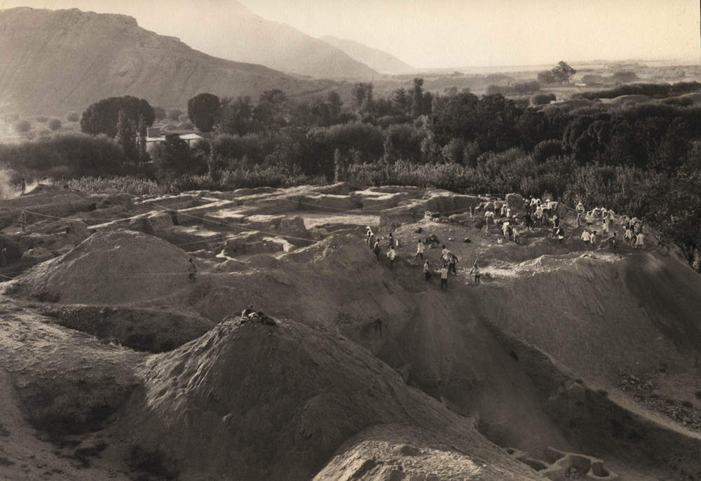
The first truly archeological research at Ray was undertaken by the German-American archeologist Erich F. Schmidt (1897-1964), who directed the excavation under the auspices of the University of Pennsylvania Museum of Archeology and Anthropology, and the Boston Museum of Fine Arts , between 1934 and 1936. One of the main goals of Schmidt was to study the cultural cross-section of the ancient periods on the Iranian plateau. Ray was chosen because of its “key geographical position at the crossing of ancient routes from north to south and east to west, and its importance from Median times to the final destruction by Tamerlane” (Treptow, p. 14, from the Schmidt archives kept at the Oriental Institute, University of Chicago). Although Schmidt was less interested in the later periods, such as the Islamic era, he did dedicate some time to investigating them.
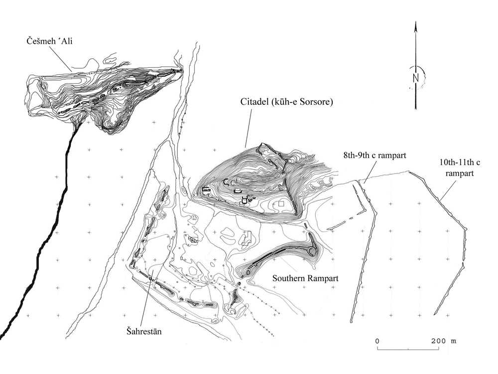
Neolithic period. In this large archeological area two mounds were the most clearly identifiable: Čašma-ye ʿAli and Kuh-e Sorsora (FIGURE 1). The distance between the two mounds is around 300 m. The mound of Čašma-ye ʿAli, which today has almost totally disappeared, was the first locus where Schmidt excavated. This location was considered to be of great importance because of its water source (in a later period revered locally as a shrine), and for its mound. This first excavation produced important results, which helped to reconstruct the earliest occupations of the Iranian plateau. The more ancient layers showed a first occupation dated by Schmidt to the Anau I period (Schmidt, 1935, p. 140; see ANAW). However, the recent studies of Voigt and Dyson (1992), also confirmed by Fazeli (2001), now define the “horizon pottery of Češmeh ʿAli” at about 5500-5200 BCE, therefore earlier than Anau I (see also Matney; Hiebert et al., p. 77). The major prehistoric ware found at Čašma-ye ʿAli during this period is brown-red painted in black. The decorative motifs varied from geometric (often zigzag) to zoomorphic patterns. These vessels were handmade and the fabric of the sherds range from thin, “egg-shell” pots to thick storage vessels. Among the different sherds of this period, there is also a bowl showing an unusual motif of detached ibex heads (Schmidt, 1935, fig. 4). Successive prehistoric occupations ranged in time from 5000 to 3000 BCE. The pottery is lighter brown-red, and the decorative patterns often are floral scrolls or palmettes with several branches. Characteristic is a jar with a high foot painted in dark brown and a body covered with geometric and vegetal motifs (Schmidt, 1935, fig. 3), the type corresponding to the early ware found at Tepe Hissar.
The excavation on the citadel provided Schmidt with some interesting results (see also Mousavi, p. 152, tab. 1). In 1935 he started a trench of 400 sq. meters, on the south terrace of the citadel, the northern part having been already damaged by the cement factory. To the lower layers belonged a grey ware type, indicating an occupation of the Early Iron Age (roughly 1000 BCE). The layers below these presented a few painted sherds of pottery (Hissar IB), corresponding to the 3rd millennium. The citadel mound was, therefore, occupied later than Čašma-ye ʿAli.
The more recent 2007 excavation in Ray sub-province (šahrestān), where the virgin soil is covered by a thick alluvium layer (2.60 m) without any anthropogenic traces, composed of dark-red compact ground and fine gravel, yielded in its lower layers a very small quantity of dark grey pottery fragments, some of which are decorated with incised lines and applied motifs. While the present state of research concerning these lower layers is still incomplete, it could be possible that the area immediately underneath was also occupied during this period if the citadel presented an occupation relating to the Early Iron Age.
Parthian period. At Čašma-ye ʿAli, the layers above this first Neolithic occupation revealed the presence of an important mud brick structure. This was part of a unique complex, described by Schmidt as a temple (Schmidt, 1935, p. 56) and dated by coins to the Parthian period, thus showing an occupation lapse of 3000 years. This architectural complex was composed of a central court surrounded by rooms (FIGURE 2). Some coins dating to Mithradates I (171-138 BCE) and to Pacorus II (78-105 BCE) were found inside this building. Outside the complex, on the same level of construction, were found 500 copper coins, dating to Mithradates II (123-88 BCE), Orodes I (57-37 BCE), Phraates II (37-2 BCE) and Vonones I (8-12 CE). Glazed greenish-blue sherds also occurred. Grey bowls belonging to this area are conserved today in the National Museum of Iran (Muza-ye Melli-e Irān). Some of these bowls, whose vertical loci has been established thanks to the Schmidt’s excavation notes, correspond to the Parthian building, are light grey, have a very fine fabric, and correspond to a pottery type “clinky ware” (corresponding to the “céramique sonore” in Haerinck’s usage, pp. 196-200) found during the recent excavation in the šahrestān (sub-province), dated to the early Parthian period (Rante, 2008, pp. 192-94; see also Hansman and Stronach, fig. 14:6).
The excavations of the complex in the šahrestān, and of site’s rampart, showed its foundation to be of the early Parthian period (FIGURE 4). The rampart is situated over a rock crest about 6 m above the plain. It was constructed in one phase, in two different manners: 45x45x15 cm mud bricks for the external part (about 1.5 m thick at the rock crest height) and 38x38x10/12 cm mud bricks for the rest (about 4.5 cm thick at the rock crest height). This type of construction, with the use of similar sizes of mud brick, can also be identified at the Bactres (Balkh; Balḵ) site, specifically Bactres IA (Le Berre and Schlumberger, figs. 12, 15). The rampart consists of five towers, of which the two more easterly are square (the largest now has a round profile due to later restorations). The middle tower, added later, is round, and the two others have suffered from too much destruction to be clearly described. Between the round tower and the following tower to the west, where the rock crest is practically at the same height as the plain, a portal about 6 m wide at the base has been identified. The grey “clinky ware” ceramic fragments, some mixed in with the mud bricks and mortar, which were found during the excavation of this rampart and also at the foundations, testify to its initial Parthian construction. Some layers above the bottom of the test trench in the šahrestān showed numerous light grey “clinky ware” sherds, confirming the Parthian occupation.
It is likely that the citadel also presents an important Parthian occupation (FIGURE 4). The recent excavations at its western part brought to light its rampart, which is constructed of 45x45x15 cm mud bricks and covered by the small stone fortress at the western part of the citadel hill, dating to the Islamic era. The Iranian archeologist Ghadir Afround uncovered some parts of this important rampart, showing that the citadel was also defended by a strong wall, probably constructed during the Parthian period (2006). During the excavation, there was also a chance find of small Parthian bronze coins on the mud brick stairway leading from the small fortress to the top of the hill. The stratigraphy of the excavation on the citadel did not reach the pre-Islamic levels. Nevertheless, in the 1930s Schmidt had reached the base of the mound, at its eastern part, showing that the Islamic layers directly covered an important Early Iron Age level.
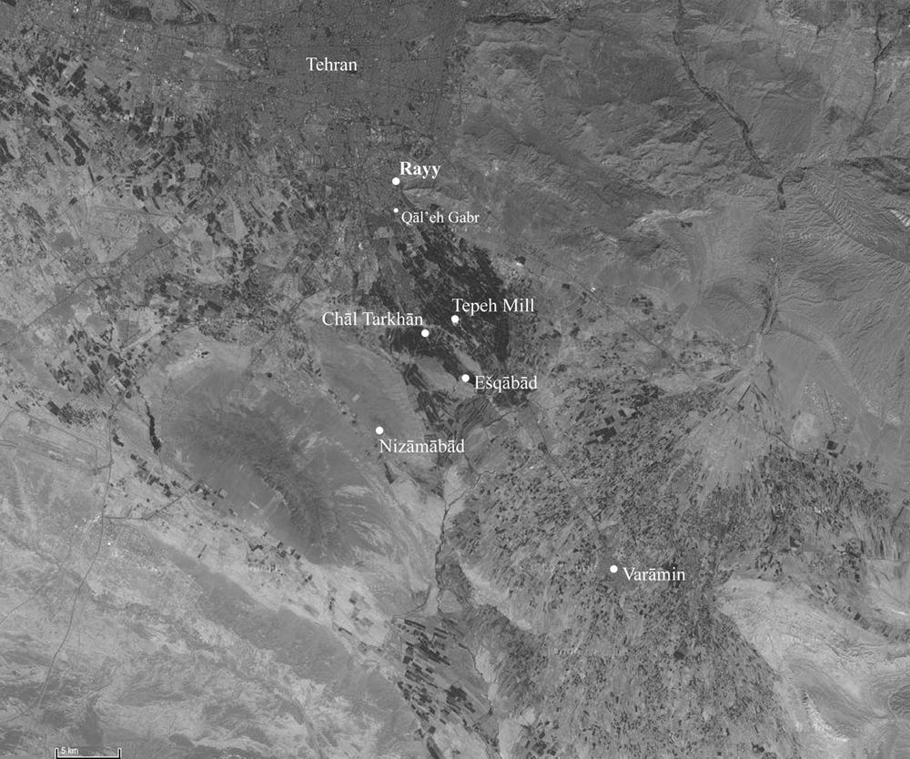
Sasanian period. “During the Sasanian period the mound (Čašma-ye ʿAli) was not inhabited,” Schmidt wrote in his excavation notes in 1930s. The archeologist excavated other sites near Čašma-ye ʿAli, finding important Sasanian occupations. The main site concerning this period is situated at Tepe Mill, where a monumental fire temple rises at the centre of another small mound (see Schmidt, 1940, p. 33; Naumann, abb. 1; Choksy, fig. 12). Two smaller mounds, at the eastern side of the temple, were excavated by Schmidt, bringing to light two small residences of the same period, successively reused and restored. These two residences, but above all the fire temple, were decorated with carved stuccoes, which today are still present inside the monument and in part conserved in a small museum nearby. The stucco motifs belong to the traditional panorama of Sasanian decoration, with zoomorphic, geometric and floral elements (see Thompson). Later, the large fire temple mound was excavated by an Iranian mission directed by Zarrin-Tāj Šeybāni (unpublished).
Near the fire temple, towards the west and south-west, lay other Sasanian settlements (FIGURE 3), such as Čāl Tarḵān, Ešqābād and Neẓāmābād (see Thompson), a few kilometers southwest of Tepe Mill. These also yielded important stucco material, which always conform to the Sasanian themes, but have not been sufficiently studied. Another Sasanian site where Schmidt put in a test trench was Qālʿa Gabr, several meters south of the citadel and the fortified city (šahrestān). During the Islamic period this small “castle” was absorbed by the latest city wall and became a gate (Bāb al-Ṣin, “The Gate to China”).
The excavation in the šahrestān has provided an interesting succession of layers with some samples of Sasanian sherds (FIGURE 4). The layers above the first occupation phases of the šahrestān, and the layers just below the first Islamic occupation, where the first Islamic period glazes (opaque white) were easily recognized, presents a ceramic type with a fabric different from those of the previous period. The fabric is no longer fine grey, but orange to orange-yellow with small light inclusions. Some sherds are yellower, with volcanic inclusions, and the texture is lightly friable. The excavation of the rampart showed that during this period the external façade of the wall was restored. A coin datable to the end of the 5th century (Pēroz or Kawād I?) has been found at the base of a restored part of the rampart. The excavation at the internal façade (Rante, 2008, fig. 7) brought to light a large number of jars with oblique line-printed decoration on the body. The same type of decoration, with the same yellow-buff and yellow-greenish fabric, has also been found in Merv and dated to the early and middle Sasanian period (Puschnigg, plates 9, 14). The juglet shape from Merv (MGK5; Puschnigg, plate 11, fig. 6.12, fig. A3.15) was also frequent at Ray and dated to the early and middle Sasanian period.
The citadel was probably also occupied during the Sasanian period, although there are no traces to confirm this. During the excavation inside the small fortress on the western part of the hill, few sherds similar to the stratigraphic succession have been noted. Ṭabari (pp. 2654-55) reports that the Islamic general Noʿaym b. Moqarrin was sent to Ray to suppress a revolt organized by Siāwaḵš b. Mehrān b. Bahrām Čōbin (642-643 CE). After suppressing the revolt, the general ordered the destruction of the old citadel and its reconstruction. Other Islamic sources tell of a previous Sasanian occupation of the fortified city at Ray. Nonetheless, no archeological sounding has yet yielded a clear Sasanian sequence to locate such an occupation there. On the other hand, the study of the material conserved in storage in the National Museum of Iran in Tehran, along with a general provenance from the site, has indentified some ceramic groups of Sasanian typology, similar to those noted in Tepe Mill, Čāl Tarḵān and the other Sasanian loci. This would confirm a strong Sasanian presence in Ray, not only in and near the fire temple, but in the entire archeological zone.
Islamic periods. The Islamic periods at Ray represent the most significant and extensive occupation on the site, and it is only in this period that one can reconstitute a complete plan of the city (FIGURE 5). At Čašma-ye ʿAli, before joining the Parthian and Neolithic layers, Schmidt excavated a deep (2 meters) Islamic level. In an article published in 1936, Schmidt wrote, “At Čašma-ye ʿAli we became impatient of the deposits of the Islamic Era which only disturbed and retarded the excavation” (p. 135). The “very few objects” found in these Islamic layers were great numbers of burials, small mausoleums, a few graves (containing badly preserved skeletons) and a tombstone in alabaster with Kufic religious inscriptions. The Islamic layers corresponded to “Middle Islamic” (Buyid/Saljuq) and also to “Early Islamic” (Umayyad/Abbasid) occupations (Keall, p. 541). Furthermore, 107 dinars coins (dated 1116-61 CE), part of the very exhaustive numismatic study of Miles (1938), and numerous “grenades” were found at this site.
Excavations on the citadel hill indicate that the citadel was occupied during the early Islamic era, utilizing the previous structures. During the first years of Muslim rule, Ray was a military outpost for the conquest and the control of the eastern provinces of the Islamic empire. Accordingly, this major politico-military site was occupied by a governor and his army contingent. It is during this military occupation that Ray was partially reconstructed (FIGURE 4). This reconstruction was carried out with stones and mortar, and not with mud brick as had been the case previously; some vestiges are still visible today. This construction method corresponds to the foundations of the probable mosque found in the šahrestān. During the latest excavation, the early layers showed numerous unglazed ceramics and some monochrome green-glazed sherds. The layers above yielded the characteristic 8th-9th century glazed pottery, still with ubiquitous sherds of monochrome green. There were also numerous painted wares over a slip, under a transparent glaze and different from the more commonly known and characteristic “slip-painted” wares. In his 400 sq. m. test trench on the eastern part of the southern terrace on the hill, Schmidt found a coin dated to the first half of the 11th century, which apparently belonged to the layers above. Furthermore, after a lacuna of four centuries, a much later occupation was indicated by some Timurid materials in a layer dated 1432-33 by a coin of Šāhroḵ.
The “governmental quarter,” or šahrestān, was excavated for the first time by Schmidt in 1934. He concentrated on two mounds (Keall, fig. 3 A/B), covering architectural structures, situated between the southern foot of the citadel and the southern rampart of the šahrestān. The excavation of the eastern mound brought to light a series of square stone pier foundations, whose orientation towards Mecca suggests that they were the foundation for a mosque . Although Schmidt did not discover a meḥrāb in this building, and Keall states that, as in Sirāf, it could also have been a “warehouse” (Keall 1979, p. 541), the complex was never completely unearthed. Today, the site where the possible meḥrāb could have been located is covered by a glycerin factory. The qebla orientation of the remaining elements of the building, however, and its location within the šahrestān, strongly suggest an important function. This building, possibly a mosque, has been dated to the early Abbasid period, after some early Abbasid coins found on the floor of the building, some dating to 775 CE. Below the floor, Schmidt discovered some Umayyad coins. The western mound in the šahrestān, north of the glycerin factory, was identified as a madrasa (traditional school) because of the discovery of ayvāns opening off from a central court and small chambers flanking them. This madrasa was dated to the Saljuq period. Another madrasa, also dated to the Saljuq period, was later found by the Archeological Services of Iran (Godard, figs. 3, 6-7).
The most recent excavation in the šahrestān has provided additional information about the Islamic occupation. At about 1.5 m from the surface, two stone pier foundations were discovered. The two foundations were excavated from the probable Sasanian and Umayyad layers, where unglazed and monochrome green ceramic fragments have been collected. These were oriented, as in Schmidt’s excavation, towards north-east/south-west. A group of opaque white fragments, whose fabric differed little from the characteristic Basra opaque white production, has been found at the base of the western pier foundation. One of these fragments, the base of a bowl, presents the “distinctive marks of spurs” on the interior, which A. Williamson presents as the characteristic marks of the opaque white Ray production (p. 16).
It is probable that this type of opaque white ceramic of Ray belongs to the early Abbasid period, and that the two newly exposed piers were part of this building. There are several factors which support this early Abbasid dating of the building, most probably a mosque, as first suggested by Schmidt. These include the coins found in the soil, as well the references in historical sources that describe the construction by al-Mahdi, the son of caliph al-Manṣur, of a mosque in the šahrestān (completed in 158/775), at the foot of the citadel hill.
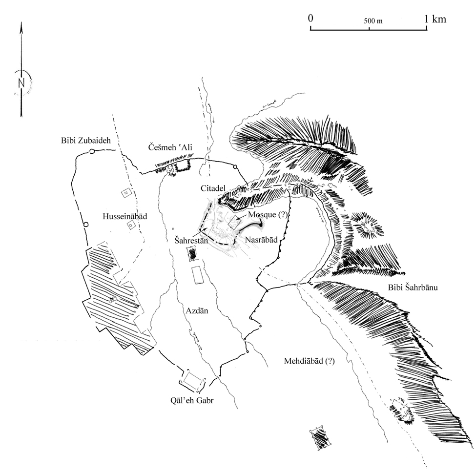
During this early Abbasid period, Ray underwent considerable restoration and expansion resulting in the creation of a new town called Moḥammadiya. Belonging to this epoch is one of the multiple restorations of the šahrestān rampart and the construction of a new line of mud brick ramparts, which can be taken as signs of the urban site’s expansion. The previous periods had seen the expansion of the city over an area consisting of the old fortified city of Ray (the citadel and šahrestān), and the sites of Bibi Zobayda, Ḥosaynābād, Čašma-ye ʿAli, Čāl Tarḵān, Tepe Mill, Ešqābād, Neẓāmābād and later Varāmin (see FIGURE 3, FIGURE 5). In later Islamic periods, the urban character becomes visible through the raising of the mud brick rampart that enclosed the entire settlement of the Islamic medieval city (Rante, 2007, fig. 7). The old fortified city was thus incorporated, along with Bibi Zobayda, Ḥosaynābād and Čašma-ye ʿAli, as a quarter of the larger city settlement of Moḥammadiya. Earlier settlements of the Islamic periods are known from historical sources, but have not been identified archeologically. At about the end of the 7th century, the historical sources already report the settlement of Arab groups (from the Ṯaqif and Bagila tribes), constituting a new quarter to the south of the fortified city. The new quarter was called Azdān, whose name according to Schwarz comes from “the people of Azd” (Schwarz, p. 751, n. 7). Two new quarters were successively constructed: Naṣrābād, named after the governor Naṣr b. ʿAbd al-ʿAziz, and Mehdiābād, which according to Yāqut was the quarter constructed for the people of the šahrestān, expropriated to permit the construction of the mosque (Schwarz, pp. 754-55). There are, instead, some archeological traces testifying to this expansion of the city towards the east, at a site which can be identified as the Naṣrābād quarter. It is probable that the first of the two last ramparts belongs to the al-Mahdi expansion of the city (second half of the 8th century), if one takes into account investigations of the šahrestān rampart and its comparison to the medieval ramparts (see Adle, 1979, 1999, for investigations during the 1970s). In fact, the construction technique and the type of mud brick (33x33x8 cm and 27x27x7/8 cm) used are identical in both sites. The pottery can be dated to the end of the 8th and 9th centuries.
In the excavations of the šahrestān, the layers above the interface covering the layers dating to the 8th-9th centuries revealed changes in ceramic fabric and shape. Fabric became lighter and buff-orange while shapes became more globular. Molded fragments of dark red fabric also belong to this period, probably from the 10th to the first half of the 11th centuries. The closed test trench context of the rampart showed some sgraffiato and slip-painted fragments (see CERAMICS XIII) at the same level. At this time, the city appears to have consolidated its limits towards the south. At the eastern part, a second rampart brushing the foot of Bibi Šahrbānu Mt. has been constructed. We do not know if this second rampart has been constructed to substitute the former, after a probable expansion of the city to the east, or if it has been constructed to enhance the earlier rampart’s defensive function.
The layers above showed a higher quantity of glazed ceramic. Among the fragments there are also some lustre wares; unfortunately, it proved impossible to determine the type of lustre because of the small size of the fragments. The ceramic analysis has recorded an occupation during the 11th-12th centuries. In this period, when the city of Ray was one of the main cities of the Saljuq dynasty, the “inner city” was at its largest expanse, as indicated by the ramparts accurately drawn by Pascal Coste (Rante, 2007, fig.7). Analysis of various places in the walled Saljuq city have confirmed this important and continuous occupation. Nevertheless, we do not have the precise data to confirm that the ramparts were constructed at this epoch or prior to it. Recent studies have shown that most likely the rampart had already been constructed during the Buyid occupation.
A burned layer 2 cm thick covered the Saljuq phase of the city. The very same burned layer was also found on the citadel and can be associated with the destruction of the entire settlement by the Mongols. The first layers excavated, between the present-day surface and the burned layer, presented some sherds belonged to the 15th century.
Bibi Zobayda is a small hill situated to the western part of Čašma-ye ʿAli, north of Ḥosaynābād. This site was also reoccupied during the Islamic periods. In his notes Schmidt wrote that the sites of Čašma-ye ʿAli and Ḥosaynābād were on the same chronological sequence. Coins of Umayyad, early Abbasid, Saljuq and Mongol times provide evidence for this chronological scale. The ceramics found there cover this entire chronology. Opaque white bowls and dishes, sometimes with Kufic inscriptions, and, above all, designs painted over slip and under glaze have been recorded.
A test trench showing a comprehensive Islamic pottery sequence was excavated in the Abu’l-Fatḥ-zāda garden, first by Pope and Rabenou, and then by members of the Schmidt’s team. Unfortunately, Schmidt divided this large Islamic period into only three levels (“Islam I-III”), thereby rendering the stratigraphical sequence too approximate (Schmidt, 1936, pp. 83-87; for a general view of the material sequence, see also Treptow).
Three mausoleums were excavated and examined by Schmidt to the southeast of the city and to the south of Bibi Šahrbānu, an area that remained outside the city walls. The most elaborate one, called Naqqāra Ḵāna after the hill of the same name, contained vaulted crypts located below the ground floor of the mausoleums (see Schmidt, 1940, p. 31, pls. 35-36). This area has been identified by Adle (1979, fig. 512) as that of the two larger cemetery zones of the Ray area. After the destruction caused by the Mongols, the old settlement was abandoned and replaced, first by Varāmin to the south, then by sporadic presence on the site in the Timurid period, as evidenced by chance ceramics, and finally by Tehran itself to the north.
Bibliography:
T. Adachi, “Considering the regional differences in the Parthian fine pottery,” al-Rafidan, Journal of Western Asiatic Studies, 26, 2005, pp. 25-36.
Ch. Adle, “Constructions funéraires à Rey circa Xe-XIIe siècles,” Akten des VII. Internationalen Kongresses für Iranische Kunst und Archäologie München, 7.-10. September 1976, Berlin, 1979, pp. 511-15.
Idem, “Notes sur les première et seconde campagnes archéologiques à Rey, Automne-hiver 1354-1355/1976-77,” in F. Vallat, ed., Contribution à l’histoire de l’Iran, Mélanges offerts à Jean Perrot, Recherche sur les civilisations, Paris, 1990, pp. 295-307.
R. Besenval, “Quelques caractéristiques techniques de la céramique d’époque parthe à Tureng Tepe (Iran),” Mesopotamia 22, 1987, pp. 403-08.
J. K. Choksy, “Reassessing the material contexts of ritual fires in Ancient Iran,” Iranica Antiqua 42, 2007, pp. 229-69.
G. Curzon, Persia and the Persian Question, 2 vols., London, 1892, repr. 1966.
H. Fazeli, R. A. E. Coningham and A. M. Pollard, “Chemical Characterisation of Late Neolithic and Chalcolithic Pottery from the Tehran Plain,” Iran 39, 2001, pp. 55-71.
A. Godard, “L’origine de la madrasa, de la mosquée et du caravansérail à quatre iwans,” Ars Islamica 15-16, 1951, pp. 1-9.
E. Haerinck, “La céramique en Iran pendant la période parthe (ca. 250 av. J.C. à ca. 225 après J.C.),” Iranica Antiqua, Supplement 2, Ghent, 1983.
J. Hansman and D. Stronach, “Excavations at Shahr-i Qumis, 1967,” Journal of the Royal Asiatic Society, 1970, pp. 29-62.
Idem, “Excavations at Shahr-i Qumis, 1971,” Journal of the Royal Asiatic Society, 1974, pp. 8-22.
F. T. Hiebert et al., eds., A Central Asian Village at the Dawn of Civilization, Excavations at Anau, Turkmenistan, Philadelphia, 2003.
A. V. W. Jackson, Persia Past and Present, London, 1906.
K. Jakubiak, “The Origin and Development of Military Architecture in the Province of Parthava in the Arsacid Period,” Iranica Antiqua 41, 2006, pp. 127-50.
E. J. Keall, “The Topography and Architecture of Medieval Rayy,” Akten des VII. Internationalen Kongresses für Iranische Kunst und Archäologie München, 7.-10. September 1976, Berlin, 1979, pp. 537-43.
R. Ker Porter, Travels in Persia,, London, 1821-22.
M. Y. Kiani, “Parthian Sites in Hyrcania, The Gurgan Plain,” Archäologische Mitteilungen aus Iran 9, Berlin, 1982.
M. Le Berre and D. Schlumberger, “Observations sur les remparts de Bactres,” extrait de Monuments Préislamiques d’Afghanistan, MDAFA 19, 1964, pp. 65-103.
T. Matney, “Re-excavating Cheshmeh Ali,” Expedition 37/2, 1995, pp. 26-38.
G. Miles, The Numismatic History of Rayy, New York, 1938.
J. Morier, A Journey through Persia, London, 1812.
A. Mousavi, “La région de Téhéran à l’aube de l’Age du Fer: réflexions et commentaires sur les nécropoles du IIe millénaire av. J.-C.,” Iranica Antiqua 36, 2001, pp. 151-212.
R. Naumann, “Tepe Mill, Ein Sasanidischer Palast,” Baghdader Mitteilungen (band 3), 1964, pp. 75-77.
W. Ousely, Travels in Various Countries of the East, vol. 3, London, 1819-23.
G. Puschnigg, Ceramics of the Merv Oasis: Recycling the City, Walnut Creek, Calif., 2006.
R. Rante, “The Topography of Rayy pertaining to the early Islamic period,” Iran 45, 2007, pp. 161-80
Idem, “The Iranian city of Rayy: Urban model and Military architecture,” Iran 46, 2008, pp. 189-211.
E. F. Schmidt, “The Persian Expedition,” Bulletin of the Museum of Fine Arts 33, Boston, 1935, p. 56.
Idem, “The Excavation on the Citadel Hill,” University Museum Bulletin 1-2, 1936, pp. 79-87, 133-35
Idem, Excavations at Tepe Hissar, Dāmghān, Philadelphia, 1937.
Idem, Flights over Ancient Cities of Iran, Chicago, 1940.
P. Schwarz, Iran im Mittelalter nach den Arabischen Geographen, Leipzig, 1896.
Moḥammad b. Jarir Ṭabari, Ketāb taʾriḵ al-rosol wa’l-moluk, ed. M. J. de Goeje et al., 15 vols., Leiden, 1879-1901; repr. Leiden, 1964.
D. Thompson, Stucco from Chāl Tarkhān-Eshqābād near Rayy, Warminster, U.K., 1976.
T. Treptow, The Medieval Persian City of Rayy, Chicago, 2007.
C. Vignier, “The new Excavation at Rhages,” Burlington Magazine 25, London, 1914.
M. M. Voigt and R. H. Dyson, Jr., “The Chronology of Iran,” in Robert W. Erich, ed., Chronologies in Old Worlds Archaeology, 2 vols., Chicago, 1992; I, pp. 22-78; II, pp. 125-53.
A. Williamson, “Regional Distribution of Medieval Persian Pottery in the Light of Recent Investigation,” in J. Allan and C. Roberts, eds., Syria and Iran, Three Studies in Medieval Ceramics, Oxford, 1987, pp. 11-22.
C. T. Young Jr., “The Iranian Migration into the Zagros,” Iran 5, 1967, pp. 11-34.
Originally published July 23, 2010.
(Rocco Rante)
Originally Published: January 1, 2000
Last Updated: July 23, 2010