

MAŠHAD-E ARDAHĀL (or Ardahār), district and settlement near Kashan, significant for its shrine and conservative traditions.
The district of Ardahāl lies on the eastern foothills of the Karkas Mountains, on the road from Kashan to Delijān. It is a fertile valley 2 miles wide and 10 miles long, dotted with a dozen villages and hamlets. A stream and several water sources feed the district, and subterranean channels (kāriz) are dug to irrigate its fields of cereals, beans, and vegetables and to sustain a rich horticulture. Cottage industry, especially carpet weaving, supplemented the traditional economy of the valley. The district has poorly preserved its original Rāji vernacular (See KASHAN ix. The Median Dialects of Kashan).
Its administrative center, Mašhad-e Ardahāl or Mašhad-e Qāli, is situated 26 miles west of Kashan, at 51°2ʹ east longitude and 24°2ʹ north latitude, and at an elevation of 5,900 feet above sea level. Mašhad-e Ardahāl/Qāli, in more specific terms, refers to the shrine that stands half a mile uphill to the northwest of the populated settlement. The village itself is referred to by the locals as Bārikarasf or Bārikarafs, corresponding to Bārkarasb or Bārkaraz of the religious texts of the 12th century (see below). There seems to be confusion in contemporary sources in treating Mašhad-e Ardahāl and Bārikarasf as two different settlements (e.g., Razmārā, p. 39, lists Bārikarafs separately from Mašhad-e Ardahāl).
Historical geography. Ardahāl remains unmentioned in medieval sources written on the general geography of Iran, while it receives a fair amount of notice in local histories owing to its religious importance for Imami Shiʿism (see below). The 10th-century Tāriḵ-e Qom, preserved in a 15th-century Persian translation, cites the district as Var-e Ardahār (or Varārdahār), having seventeen villages, and states that it was one of the twenty-one districts (rostāqs) in the province (kura) of Qom (Qomi, pp. 134-35). In the following century, Ḥāfeẓ Abu Noʿaym, in his A Chronicle of Isfahan (completed in or after 1028), cites Ardahār as a dependency of Kashan (Abu Noʿaym, I, p. 31), itself a dependency of the governorship of Qom.
It was only in modern times that some detailed description of the district became available. The late 19th-century Persian treatises on Qom (authored by Arbāb and Afżal-al-Molk) place the district (boluk) of Ardahāl in the welāyat of Qom. They state that the inhabitants are predominately agriculturalists, mostly affluent and nearly urbanite, and they have sayyed lineages and their culture and vernacular resemble those of Kashan (Arbāb, p. 201; Afżal-al-Molk, p. 142). The same sources list eight villages for Ardahāl (Table 1), the largest being Mašhad, with 143 households, from which 60 individuals were employed by the shrine administration. The village Šānaq is said to have been resided by a Khorasani Arab tribe (Arbāb, pp. 201-03; Afżal-al-Molk, pp. 142-45).
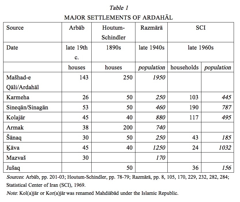
In his authoritative monograph Eastern Persian Irak, Albert Houtum-Schindler describes Ardahāl as the southernmost district of Qom and its principal village, Mašhad-e Qāli (i.e., Mašhad-e Ardahāl), with some 250 houses, surrounded by the hamlets Ḵāva, Armak, Jušaq, Šanek, Sinegān, Koljār, and Kermeha (Houtum-Schindler, pp. 78-79). A half century later, having been transferred from Kahak District of Qom to Qamṣar District of Kashan, Ardahāl rural district (dehestān) was inhabited by 5,600 people in its nineteen settlements, the largest being Mašhad, Ḵāva, Korjār, Ḥasnārud, and Dasnaqān (Razmārā, pp. 105, 100, 229 283-84; cf. Keyhān, II, p. 396). The next major national gazetteer of Iran, based on the 1966 census, states that Ardahāl was administered from Delijān District of Maḥallāt Sub-Province in Markazi Province; its major settlements were listed as Ḵāva, Ḡiāṯābād, Karajār, Kerma, Reyḥān, Lārun, and Jušaq (Statistical Center of Iran, Šahrestān-e Maḥallāt, p. 52). Mašhad-e Ardahāl was eventually transferred back to Kashan Sub-Province as a dependency of Niāsar District, while the historical boluk of Ardahāl is split by the borderline between Isfahan and Markazi provinces.
Shrines. Ardahāl owes its epithet mašhad (“shrine”) to the shrine of Šāhzāda Solṭān-ʿAli, a son of Moḥammad al-Bāqer, the fifth Shiʿi Imam. The shrine is mentioned as early as the 12th century, when it was known as Mašhad-e Bārkarasb (or Bārkaraz) or Mašhad-e Emāmzāda ʿAli, as venerated by the native Shiʿi poet Żiāʾ-al-Din Abu’l-Reżā Rāvandi in verse (Rāvandi, pp. 82, 125-27, 245; Narāqi, p. 431) and by the theologian ʿAbd-al-Jalil Qazvini Rāzi (pp. 198-99, 558).
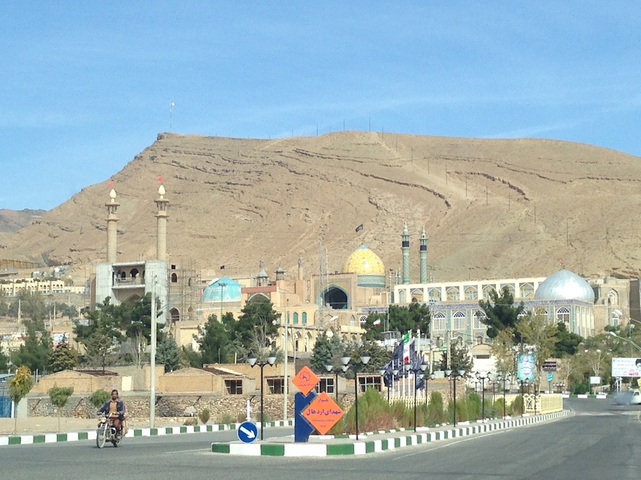
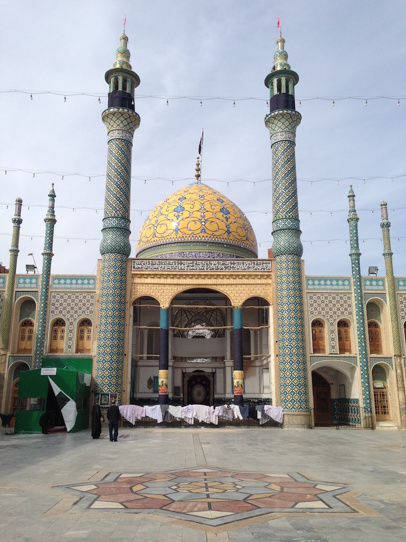
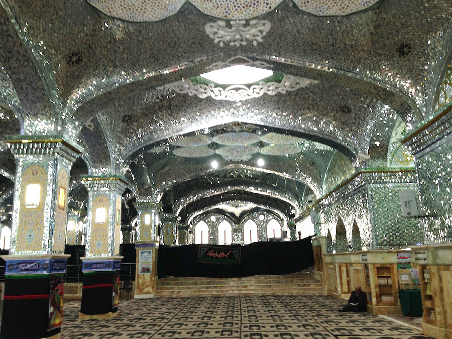
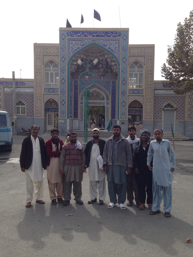
The mausoleum stands on the breast of a rocky hill overlooking the village (Figure 1). Its edifice, probably founded under the Saljuqs, has seen recurrent renovation, reconstruction, and expansion in subsequent periods, especially under the Il-Khanids, Safavids, and Qajars. But the lion’s share of the enormous complex that exists today (emulating Šāh-e Čerāḡ in Shiraz) was constructed in the 1960s and 1970s. It includes an overall refurbishing and restructuring of the complex, installment of a gold and silver tomb (żariḥ), tiling of the dome, and furnishing a modern infrastructure for accommodating an increasing number of pilgrims. In its present form the complex is centered on the domed sanctuary flanked by two minarets(Figure 2); its portal opens to the main courtyard (ṣaḥn), which is adjoined by two other courtyards (Ṣaḥn-e Ṣafā and Ṣaḥn-e Sardār), guestrooms, a cistern, and a bathhouse (for description in successive periods, see Kalāntar Żarrābi, pp. 300 ff.; Siroux, tr., pp. 21-22; Meškāti, p. 267; Narāqi, pp. 111, 125-43, 432; Ṣafari, pp. 484-86; Moširi, p. 68). More recently, the two wings flanking the sanctuary have been extended and decorated with mirror tiles (Figure 3); the construction is entirly financed by local charities and through fundraising (interviews by the author, 2016). In 1934, a dungeon (sardāba) was discovered in the complex, in which some hundred coffins stacked in three layers are reported to have contained corpses surmised to be the casualties of the battle of 1213/1798 between the state army and local insurgents under the command of Ḥosayn-qoli Khan Qājār, a brother of Fatḥ-ʿAli Shah (Marandi, p. 39; Fayż, pp. 76-78).
One-half mile downhill from Šāhzāda Solṭān-ʿAli’s shrine stands by a stream the mausoleum of Šāhzāda Ḥosayn (Figure 4), with constructions from the 16th century onwards (Narāqi, pp. 140-42). Both emāmzādas are highly venerated by the locals, and their courtyards are burial ground of local dignitaries, including the renowned contemporary poet Sohrāb Sepehri.
The abovementioned two shrines are the site of the annual festival of Qālišuyān (“carpet-washing”), an exclusive ritual with wide participation, not only from Ardahāl itself but also adjoining rural districts. It is because of this festival that the shrine of Šāhzāda Solṭān-ʿAli is known locally as Mašhad-e Qālišuyān or simply Mašhad-e Qāli. While all other Shiʿi rituals are observed with reference to the lunar Islamic calendar, Qālišuyān is held annually in the middle of the Persian month of Mehr, when the Mehragān festival was celebrated (see ĀL-E AḤMAD).
Tiragān. Another ancient festival reported to have been celebrated in Ardahāl corresponds to Tiragān. The 10th-century historian Ḥamza Eṣfahāni stated in his book Account of Isfahan (now lost) that in Qālhar, a village of Ardahāl, a ritual was held in the day of Tir of the month of Tir at a site on a cliff from which water seeped, and the people would gather the water in bowls while invoking Beydoḵt (see ANĀHID) (quoted by Abu Noʿaym, I, p. 31; about the transmission from Ḥamza to Abu Noʿaym, see Ṣādeqi, pp. 28, 33). The contemporary geographer Abu ʿAbd-Allāh Moqaddasi relates the same story but without mentioning Beydoḵt:
wa bi-nawāhī Qāšān jabal yaršaḥu karašaḥi’l-ʿarqi wa lā yasīlu fa-iḏā kāna šahrun tīr yawmi tīr min kulli sinahi ijtamaʿa ilayhi’l-nāsu bi’l-awānī wa yaqraʿahu ṣāḥibu’l-ānīyaha bifihrin wa yaqūlu isqinā min māʾika laʿallahu kaḏā wa-kaḏā fa-yajtamaʿu li-kulli wāḥidin qadri’l-ḥājahi
And in the region of Kashan at a mountain water seeps like sweat but does not flow. Then when the day of Tir of the month of Tir arrives every year, the people congregate at the mountain with bowls, and the owner of the bowl strikes [it] against it (the rock) and says: ‘Give us from your water so that it becomes such and such’; then water gathers for each up to his need. (Moqaddasi, pp. 396-97; cf. Ebn Rosta, p. 158)
More than eight centuries later, the Kashani historian ʿAbd-al-Raḥim Kalāntar Żarrābi in his Merʾāt al-Qāsān gave an account of a water ritual performed in the village of Kala at the foot of Mt. Qadamgāh (Kalāntar, pp. 46-47). Comparable accounts were documented from local elders in a recent ethnography (Mašhadi Nušābādi, pp. 94-95).
Esbandi. Ardahāl is located in the core of the geographical domain that celebrated Esbandi, a festival with roots in ancient Iranian traditions connected to the deity Spandārmad. It was held on the eve and the first day of Esfand, the last month of the traditional Jalāli solar calendar, corresponding to 25 Bahman (14 February) of the current Persian calendar. In Ardahāl’s Sinegān/Sinaqān, the Esbandi rites included serving a ritual meal as well as sending elaborate gifts to one’s fiancée (Enjavi Širāzi, p. 97; see also KASHAN vi. The Esbandi Festival). Esbandi seems to have faded away after the Islamic Revolution of 1979.
Sacredness and the name. As stated above, Ardahāl conserved three major ancient festivals, even if in disguise of Shiʿi rituals, long after they were abandoned in most places on the Iranian Plateau. The spiritual gravity and blessedness of Ardahāl is further implied from two important accounts (rewāyat) attributed to Shiʿi Imams, without allusions to the existence of the shrines therein. The Eighth Imam is quoted as referring to Varardahār (< Var-e Ardahār in all likelihood) as a fine place (niʿma’l-mawḍiʿu Warardihār) (Qomi, 2006, pp. 271-72; Majlesi, LX, p. 214, §27). The First Imam, ʿAli b. Abi Ṭāleb, is quoted from one of his sermons (ḵoṭba) as having anticipated that a certain Ḥasani, the ruler of Ṭabarestān, would devastate Qom, with the effect of the residents of Qom taking refuge to Mt Varardahāl (Qomi, 2006, pp. 277; Majlesi, LX, p. 215, §36).
The very name of Ardahāl also points to a hallowed substratum of the valley. The first part of the toponym is impeccably a regular development of the Old Iranian *arta- (Avestan aṧa-), as also found in the toponyms Ardestān, Ardakān, Ardabil, and Ardal, among others. The second component of the name may plausibly have derived from the Old Iranian root *har- “to guard, observe, watch” (< IE *ser-; cf. ALBORZ i. The name), with possible reflexes in the name of the nearby village Qālhar and Mt. Ar overlooking Nešalj. If these conjectures are correct, the district should have been believed, since time immemorial, to be looked after by the guardian of Truth, looking down at Bārikarasf from the hill on which the venerated emāmzāda shrine stands now.
Bibliography:
ʿAbd-al-Jalil Qazvini Rāzi, Ketāb al-naqż: Baʿż maṯāleb al-nawāṣeb fi naqż “baʿż fażāʾeḥ al-rawāfeż,” ed. Mir Jalāl-al-Din Moḥaddeṯ Ormavi, Anjoman-e āṯār-e melli, series no. 143, Tehran, 1979.
Abu Noʿaym Aḥmad b. ʿAbd-Allāh Eṣfahāni, Ketāb ḏekr aḵbār Eṣbahān, ed. Sven Dedering, 2 vols., Leiden, 1931-34.
Ḡolām-Ḥosayn Afżal-al-Molk, “Ketābča-ye tafṣil o ḥālāt-e dār-al-imān-e Qom,” ed. Ḥosayn Modarresi Ṭabāṭabāʾi, Farhang-e Irān-zamin 22/1-4, 1977, pp. 67-150.
Jalāl Āl-e Aḥmad, “Mehragān dar Mašhad-e Ardahāl,” Andiša o honar 5/6, Ordibehešt 1944 Š./1965, pp. 711-16; reprinted in idem, Arzyābi-e šetābzada: hijdah maqāla, Tabriz, 1965, pp. 197-207.
Moḥammad-Taqi Beyk Arbāb, “Ketābča-ye tafṣil-e aḥvālāt-e dār-al-imān-e Qom,” ed. Ḥosayn Modarresi-Ṭabāṭabāʾi, Farhang-e Irān-zamin 22/1-4, 1977a, pp. 17-66.
Idem, “Ketābča-ye tafṣil-e ḥālāt o nofus-e o amlāk-e dār-al-imān-e Qom,” ed. Ḥosayn Modarresi-Ṭabāṭabāʾi, Farhang-e Irān-zamin 22/1-4, 1977b, pp. 151-206.
Edāra-ye āmār o saršomāri (Vezārat-e kešvar, Edāra-ye koll-e āmār o ṯabt-e aḥvāl), Ketāb-e asāmi-e dehāt-e kešvar I, Tehran, 1950.
Sayyed Abu’l-Qāsem Enjavi Širāzi, Jašnhā va ādāb o moʿtaqedāt-e zemestān I, Tehran, 1973.
ʿAbbās Fayżi, ed., Ganjina-ye āṯār-e Qom, 2 vols., Qom, 1970-71, pp. 50-78.
Google Earth, at google.com/earthindex.html; consulted 5 November 2013.
Albert Houtum-Schindler, Eastern Persian Irak, London, 1897.
ʿAbd-al-Raḥim Kalāntar Żarrābi (Soheyl-e Kāšāni), Merʾāt al-Qāsān, ed. Iraj Afšār, as Tāriḵ-e Kāšān, 4th ed., Tehran, 1999.
Masʿud Keyhān, Joḡrāfiā-ye mofaṣṣal-e Irān, 3 vols., Tehran, 1921-22.
Moḥammad-Reżā Majidi, Guyešhā-ye pirāmun-e Kāšān o Maḥallāt, Tehran, 1975.
Mollā Moḥammad-Bāqer Majlesi, Biḥār al-anwār LV, Beirut, 1983.
Moḥammad-Bāqer Marandi, Nur-e bāher, Qom, 1381/1961.
Moḥammad Mašhadi Nušābādi, “Bāzšenāsi-e parastešgāhhā-ye zartošti dar rustā-ye Kala-ye Kāšān,” Majalla-ye adyān o ʿerfān 44/2, 2011, pp. 85-100.
Noṣrat-Allāh Meškāti, Fehrest-e benāhā-ye tāriḵi o amāken-e bāstāni-e Irān, Tehran, 1970.
Moqaddasi, Aḥsan al-taqāsim fi maʿrefat al-aqālim, ed. Michaël Jan de Goeje, BGA III, Leiden, 1877; tr. Basil A. Collins, as The Best Divisions for Knowledge of the Regions, Reading, UK, 1994.
Ḡolām-Ḥosayn Moṣāḥeb, ed., Dāyerat-al-maʿāref-e fārsi II, Tehran, 1966, p. 2783.64-69.
Ḥasan Narāqi, Āṯār-e tāriḵi-e šahrestānhā-ye Kāšān o Naṭanz, Tehran, 1969.
Ḥosayn Qaračānlu, “Emāmzāda Solṭān-ʿAli (Mašhad-e Ardahāl),” Mirāṯ-e jāvidān, no. 52, Winter 1384 Š./2006, pp. 75-82.
Ḥasan b. Moḥammad Qomi, Tāriḵ-e Qom, tr. Tāj-al-Din Ḥasan b. ʿAli b. Ḥasan b. ʿAbd-al-Malek Qomi, ed. Moḥammad-Reżā Anṣāri Qomi, Qom, 2006.
Żiāʾ-al-Din Abu’l-Reżā Rāvandi, Divān al-sayyed wa’l-emām Żiāʾ-al-Dīn Faḍl-Allāh Rāvandi, ed. Sayyed Jalāl-al-Din Moḥaddeṯ Ormavi, Tehran, 1955.
Ḥosayn-ʿAli Razmārā, ed., Farhang-e joḡrāfiāʾi-e Irān (ābādihā) III: Ostān-e Dovvom, Tehran, 1950, pp. 283-84.
ʿAli-Ašraf Ṣādeqi, “Taʾammol-i dar do tāriḵ-e qadim-e Eṣfahān,” Majalla-ye bāštān-šenāsi o tāriḵ, nos. 8-9, 1991, pp. 27-45.
Ḥosayn Ṣafari, “Mašhad-e Ardahāl,” in Iraj Afšār and Karim Eṣfahāniān, eds., Pažuhešhā-ye Irān-šenāsi: Nāmvāra-ye Doktor Maḥmud-e Afšār XIII, Tehran, 2002, pp. 479-91.
Maxime Siroux, Anciennes voies et monuments routiers de la région d’Ispahān Mémoire de l’Institut Français d’Archéologie Orientale du Caire, no. LXXXII, Cairo, 1971; tr. Mehdi Mašāyeḵi as Rāhhā-ye bāstāni-e nāḥia-ye Eṣfahān o benāhā-ye vābasta ba ānhā, n.p., ca. 1978.
Shia News, at www.shia-news.com/fa/news/54854, consulted 20 June 2016.
Statistical Center of Iran (SCI)/Markaz-e āmār-e Irān (Sāzmān-e barnāma va budje), Village Gazetteer/Farhang-e ābādihā-ye kešvar XIV: Ostān-e Markazi, Tehran, 1969.
(Habib Borjian)
Originally Published: November 15, 2016
Last Updated: December 16, 2016
Cite this entry:Habib Borjian, “MAŠHAD-E ARDAHĀL,” Encyclopædia Iranica, online edition, 2016, available at http://www.iranicaonline.org/articles/mashad-e-ardahal (accessed on 15 November 2016).