

ḴUR, oasis on the southern border of the Great Desert in central Persia; the administrative center of the sub-province of Ḵur and Biābānak.
Ḵur is situated at lat 33 47′ N, long 55 05′, low down at the elevation of 2,705 feet (825 m) on the southern rim of the huge cradle that forms the Dašt-e Kavir, a salt desert left behind by an ancient sea (see DESERT). On finer satellite maps, one sees Ḵur surrounded by long stretches of desert and broken mountain chains, and that it lies on a shallow slope descending from the Taštāb Mountain (cf. Hedin, 1918-27, Plate 5 and Map 3). Hot and extremely arid summers and mild winters with windstorms and flooding characterize the climate. With only a few frost nights annually and seldom snowfalls, Ḵur falls within the northern boundary of date palm cultivation in Persia.
Although the Biābānak district itself has been known since the 10th century, there is no mention of Ḵur in sources until early modern times. There were however two similarly named medieval villages, Ḵuri(n) and Ḵur, in the district of Ṭabas (Le Strange, p. 361), some 200 km east of Biābānak; these settlements do not exist any longer. (There are also more settlements carrying the name Ḵur in the districts of Tun, Birjand, Kāšmar, Mašhad, and Daragaz in Khorasan; see Razmārā, IX, pp. 153-54; Adamec, I, pp. 344-45, II, pp. 402-3; Pāpoli et al., pp. 228-29.) This leads to the conjecture that the oasis of Ḵur in Biābānak could have been populated by and named after possible settlers from the Ṭabas area, as a possible consequence of drought or earthquakes, resulting in destruction of subterranean canal systems. This conjecture is supported by the fact that the inhabitants of the nearby Garma oasis refer to Ḵur as “Hesb” (Ḥekmat, p. 55), possibly an earlier name of Ḵur. (Hesb, too, has toponymous varieties in Khorasan, e.g., Ḵusp near Birjand.) Worth mentioning is the two different readings associated with the spelling ḵwr خور as a toponym, namely Ḵur and Ḵvor. The first pronunciation holds for the subject of this article, should we rely upon the native usage.
The earliest known attestation of Ḵur is found in the history of Ḥayāti Tabrizi, compiled in 961/1554, on the reign of the Shah Esmāʿil I. In the context of the campaign of the winter of 911/1516 from Yazd to Ṭabas via Biābānak, Ḥayāti mentions the fortress of Ḵur (qalʿa-ye *Ḵur) belonging to the Arabs of Biābānak (fols. 191r-192r; ed., pp. 356-58). This early Safavid reference notwithstanding, there is no mention of Ḵur in major Safavid sources, ʿĀlamārā-ye ʿabbāsi, Afżal al-tawāriḵ, and Taḏkerat al-moluk. Another early evidence of Ḵur is found in an inscription on a vexilloid, dated 974/1566-67, endowed to the sayyeds of Ḵur; it reads: waqf kard qorbatan ela’llāh in sar-ṭawq-rā Sayyed Ḥasan b. ʿAli [?] ḵuri bar sādāt-e Ḵur-e Biābānak dar tāriḵ-e sana-ye 974 (from the photograph of the vexilloid in Ḥekmat, p. 381).
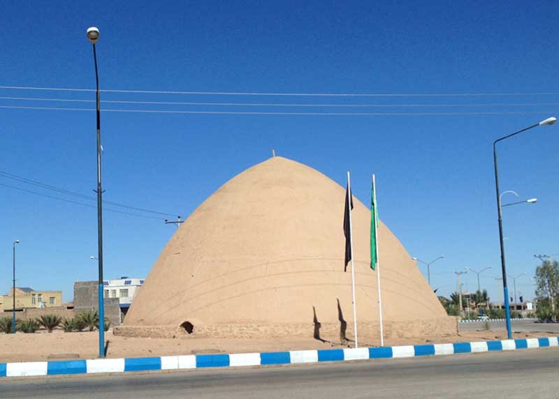
According to a local tradition, Shah ʿAbbās I, en route to Khorasan, visited Ḵur, where he assigned a certain Sayyed Dāvud to convert the Zoroastrian inhabitants to Islam, and where the shah and his escort Mollābāši each built a cistern (Figure 1). This anecdote is linked in popular culture to Sayyed Dāvud’s sanctuary (gonbad) and the cisterns Ḥowż-e Šāh and Ḥowż-e Mollā (Dastān, p. 34; Ḥekmat, p. 69; Ṭoḡrā, 2010, pp. 173-74; idem, 2012, pp. 78-81). The story of the shah’s visit is uncritically affirmed by certain scholars (inter alia, Moṣāḥeb, p. 922). However, the short account of Jalāl-al-Din Monajjem Yazdi, in his chronicle Tāriḵ-e ʿabbāsi, of Shah ʿAbbās’s trip of the year 1011 (1602) from Isfahan to Khorasan only designates Čāh Maji as a caravan camp in Biābānak (Jalāl-al-Din Monajjem, p. 238); this suggests that the itinerary took a shortcut from Nāʾin to Čāh Maji on the way to Ṭabas, thereby bypassing the village of Ḵur altogether (communication with Sayyed ʿAli Āl-e Dāvud, 2015).
The rise of Ḵur must have come about under the Qajars, when it became the seat of the governor (nāyeb al-ḥokuma) of Qorā-ye Sabʿa (Seven Villages), also known then as the Jandaq o Biābānak district. A major source of this period is a monograph compiled in 1884 (commissioned within a national geographic project launched by the Persian Ministry of Science) by Ebrāhim Dastān Yaḡmāʾi, the son of the renowned poet Yaḡmā Jandaqi, both from Ḵur notwithstanding their “Jandaqi” nesba. In their days Ḵur was irrigated by three subterranean channels (kāriz), with the names of Kalāḡu, Šuru, and Dehzir, and by the spring source of Daryāšu, which all discharged salt water, of which only Dehzir’s was potable, although still brackish. One farsaḵ west of Ḵur, a seasonal river of extremely saline water was a source of mechanical energy for five watermills, while two more watermills had been planted in the kārizes. Ḵur had 460 households, 840 male and 860 female residents, and several hamlets and farms, of which only Jegārg and Ṭāherābad prospered (Dastān, pp. 32-38; on ʿAbbāsābād village, see Ṭoḡrā, 2012, pp. 99-104).
Two European travelers offer valuable information on Ḵur as well. According to the British colonel Charles M. MacGregor, who traversed the district in 1875, Ḵur was 2 miles in diameter with 400 mudbrick houses but just a few wind towers (bādgir) forming the skyline. The inhabitants were “Persians, Arabs, and Sayyeds,” and women wore white veils instead of the national blue standard (MacGregor, I, pp. 91 ff.). The great Swedish geographer Sven Hedin describes Ḵur in 1906 as a large village of some 2,500 inhabitants living in 500 mudbrick houses. Camel transport dominated the economy, and the villagers owned some 1,000 camels, as well as 1,200 sheep and 150 cows. Village men not engaged in caravan transport worked in palm groves, where half of the 10,000 date palms formerly there had been frostbitten and died due to the unusually heavy snow of 1903. The ground between palm trees was sown with wheat and barley, which was insufficient even for local consumption. Pomegranates, pistachios, melons, beets, vegetables, and cotton were also grown in Ḵur (Hedin, 1910, I, pp. 407 ff.; idem, 1918-27, I, p. 35). (See also Vaughan; Gazetteer of Persia, pp. 328-29.)
The village once had a wall around, but this was already wrecked in the more secure years of the later Qajars, while the gates were still known as Konu, Kalāḡu, Qolihā, Bozhā, Ka(n)lu, ʿArabhā (2 gates) in the 19th century (Dastān, p. 36); cf. Bozhā, Qolihā, ʿArabhā, Pāy-e Fenjān-e Kalāḡu, Lerdku, Pošt-e Hesār, Lengu, and Sokoru in the 20th century (Amini, 2005, p. 30); these names also reflect major quarters of the old Ḵur. Another remnant of earlier, insecure times was a fort in the middle of the village, which was later used as warehouse (Dastān, p. 36). The vestiges of the fort, as well as the wall and its moat, were leveled flat in favor of the expanding farmland under Reza Shah (Ḥekmat, pp. 56, 69). The morphology of Ḵur was shaped by narrow lanes, some roofed (sābāṭ), among adobe houses. Two squares (lard), two major mosques, Dāru and ʿArabān, a bathhouse, and a caravanserai constituted communal spaces of the oasis, but there was no bazaar (Dastān, p. 36; Hedin, 1910, I, pp. 407; Ṭoḡrā, 2012, p. 97).
While new quarters have been added within a grid of street blocks, the old Ḵur was formed organically along the Dehzir (“under the village”) subterranean channel, which forks into two branches while passing under Ḵur. A stairwell (rāḵčuna) ran from the interior of each house down onto a platform (pāyāb) inside the kāriz’s conduit. For those houses standing offset from the conduit, there were communal pāyābs, which were equipped with stalls used as a lavatory and washbasins for washing the fodder; public pāyābs were Lard, Ḡaffur, Ḥayāta, Ḥazun, Meydān, Ṣafar, Moḥebbi, ʿĀli, Qādi, and Šāyagān (Dastān, p. 38; Ḥekmat, pp. 203-4). To preserve the precious drinking water, Ḵur was well equipped with several old domed cisterns, known as ḥowz, including Šāh, Mollā, Ḥāj Moḥammad, Hemmat, and Moqimi (idem, p. 196). More recently, to provide quality drinking water, deep wells have been dug, but to the frustration of Ḵuris they not only yielded saline water but were assessed as harmful to the hydrology the existing kārizes. The only practical solution to the problem of water has been the transport of freshwater by tanker trucks from Ārsun and Bāzyāb villages since 1962 (idem, pp. 196-97), when the accessible water sources could no longer support the growing population of Ḵur.
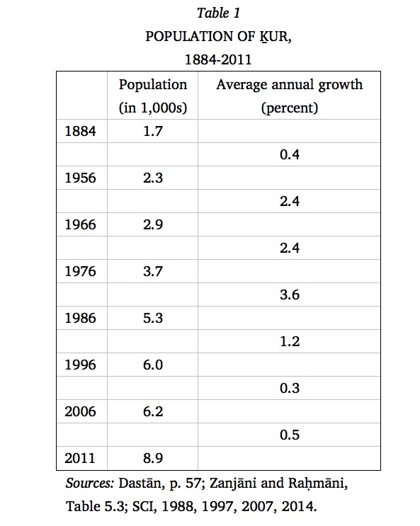
The population of Ḵur has grown fourfold since the count of 1884 (Table 1). The growth curve took a steep slope in the second half of the 20th century (owing to better hygiene) and reached a zenith in the period following the Islamic Revolution of 1979, when the government discouraged birth control. Emigration to urban centers has played a significant role in offsetting both the high rate of population growth and the inflow of settlers from the surrounding hamlets and farms, which have increasingly been deserted in the last decades (cf. Ḥekmat, pp. 275-78). Not long after the population of Ḵur was disclosed as surpassing the threshold of 5,000 in the 1986 decennial census, the former village won the status of city (šahr).
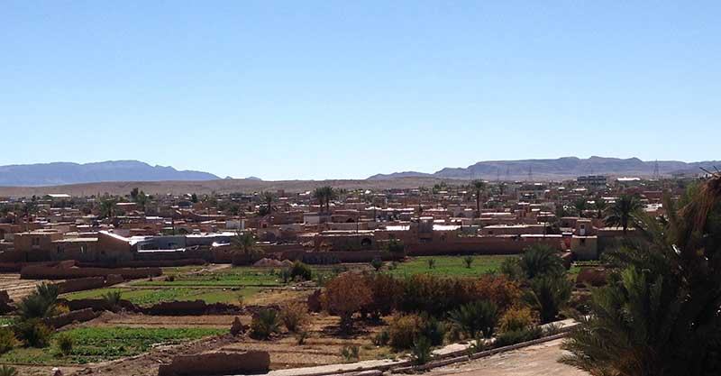
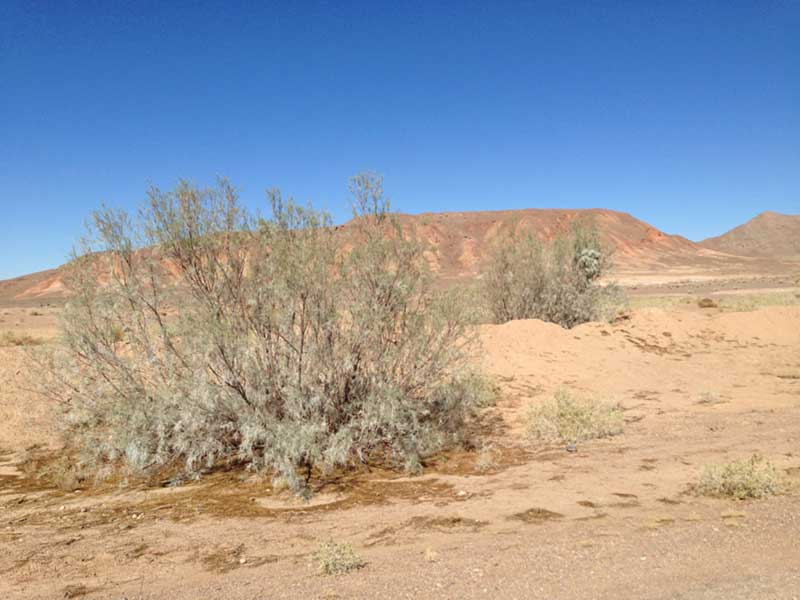
The economy was much reliant on camel tending (mokāri; Honari, 1975b), as long as Ḵur was a major nodal point on strategic grid of caravan roots, while sheep and goat herding played a minor role. Until lately the chief occupation of the Ḵuris remained date farming, which formed the principal cash crop of the village (Redard; Honari, 1971). Palm plantations (mogestān) (Figure 2) of Ḵur are spread over 150 hectares of farmland and 20 additional hectares of its satellite farms. Notwithstanding the lucre from the palm trees in normal years, their recurrent destruction by enduring frost has been reported during winters of the 1880s (Dastān, pp. 33-34), 1903 (Hedin, 1910, p. 407), 1934, 1963 (Ṭoḡrā, 2012, p. 105; Ḥekmat, pp. 44, 26), and 2007 (Āl-e Dāvud, 2009). Much of the plantations were dilapidated in 2014 (personal field notes). Subsistence farming of grains and fruits (pomegranates and figs, and some grapes and apples) took place within the palm groves, while medical and industrial products of resin asafodia (Pers. anḡuza, Khuri heng), tragacanth (katirā), madder (ronnās), and lif were exported (Yaḡmāʾi; cf. Ṭoḡrā, 2010, pp. 128, 347-53; idem, 2012, pp. 93-94); a common shrub is a kind of saxaul locally known as kuruz (Figure 3) (on flora, see Ṭoḡrā, 2012, pp. 93-94, 119-21). The irrigation water is supplied by two of the aforementioned kārizes (Kalāḡu and Dehzir) and the Daryāšu water-source (Amini, 2005, pp. 8-9; Ḥekmat, p. 275). Cottage industry of spinning and weaving (karbāsbāfi, barakbāfi, lif-e-ḵormā-bāfi; Keyhān, II, pp. 487-88; Razmārā, X, p. 80) were excelled by the womenfolk. In central Ḵur, Lard-e Toromtin (“spider square”) is perceived reminiscent of the days that women would bring out their spinning wheels and worked, sometimes in a spirit of competition, until well after dusk (Ḥekmat, p. 100; Ṭoḡrā, 2012, p. 129). Carpet weaving became a major occupation since its revival in 1960 (Ḥekmat, p. 275; Ṭoḡrā, 2010, p. 225, idem, 2012, pp. 94-95).
Ḵur is a stronghold of Persian traditions. It is one of the last places that observed the mid-winter festival of Sada (until the 1960s), when people made big bonfires and recited the rhyme: panjāh-o-panj ruz be Nowruz o sad be nāla “fifty five days to Nowruz and a hundred to the harvest of cereals” (Afšār-Širāzi et al., pp. 32-35; Ṭoḡrā, 2010, pp. 90-91; Ḥekmat, p. 411; cf. celebration of the Sada in rural Khorasan, reported in Šakurzāda, pp. 113-20; Purkarim, p. 68; Mirniā, pp. 226-27; Rażi, pp. 604-8). The festival of Čahāršanba-Suri was observed, contrary to its mainstream calendric position, in the eve of the last Wednesday of the lunar month of Ṣafar, when the children would kindle fires on rooftops and throw its embers down into the alleys, and the women would hold their own feasts (ʿAskari and Honari, pp. 33-34; Ḥekmat, pp. 411 ff.). During the last night of the year, Šab-e Bibihur, people would keep the lights burning overnight and the sacks and jars of cereals open all night, believing that Bibihur would visit the house brighten with light and would offer blessing by touching the grocery and food (Ḥekmat, p. 411). In Ḵur the Nowruz tablecloth, called Ḵān-e Nowruzi, held an assortment of nuts and fruits, as well as the celebrated samanu, an indispensible Nowruz snack across the Iranian world (see Haft Sin) (idem, p. 364). Besides Sizdah Bedar, which concludes the Nowruz chain of festivals in most parts of Persia, the Ḵuris would also spend outdoors in the Heždah Bedar, the eighteenth day of the New Year, with the distinguished custom of sprinkling water on each other (Āl-e Dāvud, 2009). (Curiously, the observation of the eighteenth day of Nowruz is also mentioned in the memoirs of the Mughal emperor Jahāngir, p. 245.) On the fifteenth day of the Persian month of Mordād, an agricultural feast would be held at dawn celebrating the release of irrigation water from the kāriz.
Among the most illustrious traditions in Ḵur which have survived to this date are the Shi’i rites held during the lunar months of Moḥarram and Ṣafar (Ṭoḡrā, 2010, pp. 85-87), when taʿzia and šabihḵˇāni are played every single day on sequences of dramas written by various Ḵuri poets (Honari, 1974, pp. 24 ff.; idem, 1975a; Ḥekmat, pp. 411 ff.; Ṭoḡrā, 2010, pp. 125-28, 197-98). A series of folkloric songs and poems from Ḵur have been published by Lesān-al-Ḥaqq Ṭabāṭabāʾi (2007, 2008, 2009).
Notwithstanding its geographical isolation and remoteness, Ḵur has been the birthplace of a chin of eminent men, beginning with Yaḡmā Jandaqi in the early 19th century, followed by his son Mirzā Ebrāhim Dastān and Esmāʿil Honar Yaḡmāʾi Moʿtamed-e Divān, and culminated with Ḥabib Yaḡmāʾi (1901-84), a distinguished poet, the publisher of the literary monthly review Yaḡmā and a senator appointed by royal decree. Thanks to the untiring efforts of Ḥabib Yaḡmāʾi and his pioneering fellow villagers, a modern Ḵur was well established with modern institutions such as a school, infirmary, post office, public registry, and gendarmerie within the short period 1925-30 (Ṭoḡrā, 2010, pp. 206-13; 2012, pp. 21, 46-47, 61, 81-85). Yaḡmāʾi proved to be an audible voice for his fellow villagers by publicizing their concerns and demands (inter alia, on schools, in Yaḡmā 24/7, 1971, pp. 428-29; on disputes with forestry, in Yaḡmā 27/7, 1974, p. 428; on protesting the excavation of a deep well, in Yaḡmā 29/4, 1976, p. 254). Ḥabib Yaḡmāʾi paid frequent visits to his birthplace and opened there a library in 1970, to which he bestowed his large personal collection. His burial place is a landmark in modern Ḵur.
Bibliography:
L. W. Adamec, Historical Gazetteer of Iran, 4 vols., Graz, 1976-81.
A. Afšār-Širāzi, E. Pur Dāvud, O. Haqqnaẓariān, M. Dabirsiāqi, M. Sotuda, Ḏ. Ṣafar, H. Corbin, M. Keyvānpur-Mokri, M.-J. Maškur, M. Moʿin, and M. Moqarrebi, Jašn-e Sada, Tehran, 1324 Š./1946.
Sayyed ʿAli Āl-e Dāvud, “Asnād-e siāsi o farhangi-e Jandaq o Biābānak dar majmuʿa-ye boyutāt,” Ganjina-ye asnād 11/4 (serial no. 44), 2002, pp. 92-102.
Idem, Ketābšenāsi-e towṣifi-e Ḵur o Biābānak, Tehran, 2005.
Idem, ed., “Bāzihā o sargarmihā-ye kudakāna[-ye] yak-ṣad sāl-e piš dar Ḵur o Biābānak” [redaction of a treatise authored by Parviz Yaḡmāʾi], Faṣlnāma-ye farhang-e mardom, ser. nos. 21-22, 2007, pp. 121-26.
Idem, “Golgašt o tafarroj dar Ḵur o Biābānak,” Faṣlnāma-ye farhang-e mardom, ser. nos. 29-30, 2009, pp. 121-29.
Aḥmad Amini (Rād), Afsāna-ye kavir: Šarḥ-i bar Ḵur-e qadim hamrāh bā bargozida-ye ašʿār-e fārsi o guyeš-e ḵuri, Tehran, 2005.
Idem, Behešt-e man Ḵur, Tehran, 2010.
Aṣḡar ʿAskari Ḵāneqāh and Morteżā Honari, “Negāh-i ba marāsem-e Čahāršanbesuri dar Jupošt o Ḵur,” Honar o Mardom, no. 114, 1972, pp. 28-34.
Ebrāhim Dastān Yaḡmāʾi (Yaḡmā-ye Ṯāni), Ketābča-ye Jandaq o Biābānak, ed. Sayyed ʿAli Āl-e Dāvud as Joḡrāfiā-ye Jandaq o Biābānak, Tehran, 2006.
Gazetteer of Persia II, Government of India, General Staff Headquarters, Simla, 1914.
Naṣrallāh Falsafi, Zendagāni-e Šāh ʿAbbās-e Awwal, 5 vols., Tehran, 1955-62.
Ḥayāti Tabrizi, Tāriḵ, ms. no. 15776, National Library, Tehran; ed. Kioumars Ghereghlou, as Tārīkh-ī Shāh Ismāʿīl Ṣafavī, forthcoming.
Sven Hedin, Overland to India, 2 vols., London, 1910.
Idem, Eine routenaufnahme durch Ostpersien, 2 vols. plus a thin atlas, Stockholm: Generalstabens Litografiska Anstalt, 1918-27.
ʿAbd-al-Karim Ḥekmat Yaḡmāʾi, Bar sāḥel-e Kavir-e Namak, Tehran, 1991 (reviewed by Sayyed ʿAli Āl-e Dāvud in Našr-e Dāneš 12/2, 1991, pp. 31-33).
Esmāʿil Honar Yaḡmāʾi (Moʿtamed-e Divān), Jandaq o Qumes dar avāḵer-e dowra-ye Qājār, ed. ʿAbd-al-Karim Ḥekmat Yaḡmāʾi, Tehran: Našr-e Tāriḵ-e Irān, 1984.
M. (Morteżā) Honari, “Importance du palmier-dattier dans la vie des habitants de Xor,” Objets mondes 11, 1971, pp. 49-58; tr. Aṣḡar ʿAskari Ḵānaqāh as “Ahammiyat-e deraḵt-e ḵormā dar zendagi-e mardom-e Ḵur,” Yaḡmā 25/4, 1972, pp. 210-19.
Idem, Owsunagun. Afsānahā-ye mardom-e Ḵur, Markaz-e pažuhešhā-ye mardomšenāsi o farhang-e ʿāmma, Tehran, 1973 (reviewed by Ḥabib Yaḡmāʾi, Yaḡmā 27/9, 1974, pp. 556-57).
Idem, Āʾinhā-ye nowruzi, Tehran, 1974.
Idem, Taʿzia dar Ḵur, Tehran, 1975a.
Idem, “Šotordāri dar kavir,” Mardomšenāsi o farhang-e ʿāmma-ye Irān, ser. no. 2, 1975b, pp. 57-66.
Nur-al-Din Moḥammad Jahāngir Gurkāni, Jahāngir-nāma (Tüzük-e Jahāngiri), ed. Moḥammad Hāšer, Bonyad farhang-e Irān ser. no. 307, Tehran, 1980.
Mollā Jalāl-al-Din Monajjem Yazdi, Tāriḵ-e ʿabbāsi yā ruznāma-ye Mollā Jalāl, ed. Sayfallāh Waḥidniā, Tehran, 1987.
Ḡolām-Ḥosayn Moṣāheb, Dāyerat-al-maʿāref-e fārsi I, Tehran, 1966.
C. M. MacGregor, Narrative of a Journey Through the Province of Khorassan and on the North West Frontier of Afghanistan in 1875, London, 2 vols., 1897.
Masʿud Keyhān, Joḡrāfiā-ye mofaṣṣal-e Irān, 3 vols., Tehran, 1931-32.
S. A. Mirniā, Pažuheš-i dar šenaḵt-e ilhā o ṭawāʾef-e ʿašāʾeri-e Ḵorāsān, Tehran, 1990.
Oskar von Niedermayer, Under the scorching sun: Iran war experiences of the German expedition to Persia and Afghanistan, Dachau, 1925; tr. Keykāvus Jahāndāri, as Zir-e āftāb-e suzān-e kavir, Tehran. 1984.
Nowbaḵt Naqavi, “Gozāreš-i az Ḵur: Ostāndār-e Eṣfahān dar Ḵur,” Yaḡmā 25/2, 1972, pp. 117-19.
Moḥammad-Ḥosayn Pāpoli Yazdi et al., Farhang-e ābādihā o makānhā-ye maẕhabi-e kešvar, 2nd ed., Mašhad, 2009.
Hušang Purkarim, “Dehkada-ye Rāmšin,” Honar o mardom, no. 90, Farvardin 1349 Š./1970, pp. 54-68.
Parviz Rajabi, Jandaq o Torud, do bandar-e farāmuš-šoda-ye Kavir-e namak, Tehran: Tukā, 1978.
Hāšem Rażi, Gāhšomāri o jašnhā-ye Irān-e bāstān, Tehran, 1992.
H.-ʿA. Razmārā, ed., Farhang-e joghrāfiāʾi-e Irān, 10 vols., Tehran, 1950.
G. Redard, “Le palmier à Khur,” in W. B. Henning and E. Yarshater, eds., A Locust’s Leg. Studies in Honour of S. H. Taqizadeh, London, 1962, pp. 213-19; Persian tr. ʿA. Ruḥbaḵšān as “Ḵormā dar Ḵur,” in Sayyed ʿAli Āl-e Dāvud, ed., Yādnāma-ye Eqbāl-e Yaḡmāʾi, Tehran, 1989.
Ebrāhim Šakurzāda, ʿAqāyed o rosum-e mardom-e Ḵorāsān, end ed., Tehran, 1984.
SCI (Statistics Center of Iran, Markaz-e Āmār-e Irān), Village Gazetteer/ Farhang-e ābādihā-ye kešvar VII. Ostān-e Eṣfahān, Tehran, 1969.
Idem, Saršomāri-e ʿomumi-e nofus o maskan. Ostān-e Eṣfahān. Šahrestān-e Nāʾin [for the census years 1365, 1375, 1385 Š.], Tehran, 1988, 1997, 2007.
Idem, Saršomāri-e ʿomumi-e kešāvarzi 1367: Farhang-e rustāʾi, Tehran, 1991.
Idem, Saršomārihā, at http://liveweb.archive.org/web/20121113223706/http://www.amar.org.ir/Default.aspx?tabid=1190 (accessed 25 December 2014).
Lesān-al-Ḥaqq Ṭabāṭabāʾi, Naḵl-e omid. Gozida-ye bumisorudahā-ye šoʿarā-ye ḵuri, Tehran, 2007.
Idem, Sarv-e Irāj: Tarānahā-ʾi az Jandaq, Ḵur o Biābānak, Tehran, 2008.
Idem, Bāḡ kākā: Matalhā, afsānahā, qeṣṣahā o laṭifahā-ye mardom-e Ḵur o Biābānak, Tehran, ca. 2009.
Abu’l-Qāsem Ṭoḡrā Yaḡmāʾi, Ḵur dar āyena-ye zamān: Tāriḵ-e mardom-e Ḵur o Biābānak. Bargozida-ye yāddāšthā-ye Ṭoḡrā Yaḡmāʾi, ed. Sayyed Morteżā Āl-e Dāvud, Tehran, 2010.
Idem, Az Ḵur o ruzagārān. Ṭoḡrā-nevešt: Gozida-ʾi az dastneveštahā-ye Abu’l-Qāsem-e Ṭoḡrā Yaḡmāʾi, ed. ʿAbd-al-Karim Ḥekmat Yaḡmāʾi, Tehran, 2012.
H. B. Vaughan, “A Journey through Persia (1887-1888),” Royal Geographical Society Supplementary Papers 3, 1893, pp. 89-115.
Ḥabib Yaḡmāʾi, “Vāḥa-ye Jandaq o Biābānak yā kavirnešinān-e markazi,” Majalla-ye mardomšenāsi 2/1, 1958, pp. 42-65.
Ḥabiballāh Zanjāni and Fereydun Raḥmāni, Rāhnemā-ye jamʿiyat-e šahrhā-ye Irān 1335-1370, Tehran, 1989.
(Habib Borjian)
Originally Published: October 29, 2015
Last Updated: October 29, 2015
Cite this entry:Habib Borjian, “ḴUR,” Encyclopædia Iranica, online edition, 2015, available at http://www.iranicaonline.org/articles/khur-oasis (accessed on 29 October 2015).