

ii. HUMAN GEOGRAPHY AND ENVIRONMENT
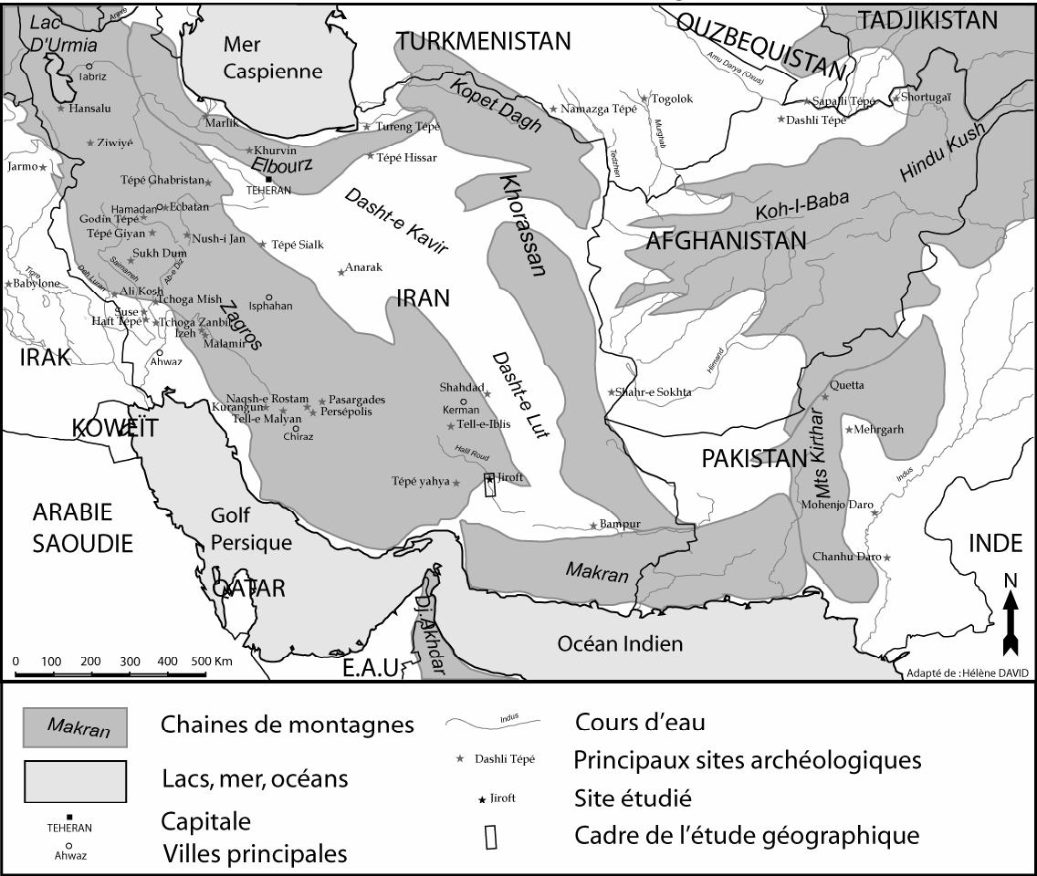
Jiroft is the regional capital of the middle section of the Halil Rud (q.v.) valley, south of the Kerman Province in Iran. The Halil Rud valley, oriented northwest to southeast, 400 km long, takes its source in the Zagros mountain range north of Jiroft, and ends in the endorheic Jaz-murian basin (Figure 1). Persian and Arab geographers called this river the Demon Stream (Div Rud). The works by Guy Le Strange (1854-1933) and Paul Schwarz (1867-1939) provide the main synthetic historical descriptions of the city and its surroundings. In the 10th century C.E., Ebn Ḥawqal (d. after 973?) described Jiroft as a large and important city, covering two miles from one end to the other. The town had a fortified wall, and was closed by the four gates Bāb Šāpur, Bāb Bam, Bāb Sirjan, and Bāb al-Moṣallā. His contemporary Moqaddasi (Miquel) added that at that time Jiroft was larger than the city of Eṣṭaḵr (q.v.) and its houses were mostly built of clay bricks on stone foundations. Waterpower was used to operate 20 to 50 mill wheels. Moḥammad b. Ebrāhim (early 17th century) mentions in his Saljuq chronicle that during the 12th century Qamādin was “a place at the gate of Jiroft where foreign merchants from Rûm (Greece) and Hind had their warehouses and where travellers by sea and land could store their goods” (p. 48; cf. Le Strange, p. 314). Qamādin’s shops were filled with “the precious goods from China, Transoxiana, and Khitây, from Hindustân and Khurâsân, from Zanzibâr, Abyssinia, and Egypt, also from Greece, Armenia, Mesopotamia, and Adharbâyjan” (Moḥammad b. Ebrāhim, p. 49). Marco Polo (1254-1324) referred to the Persian Qamādin as Camadi, or even the city of Camadi. According to Moḥammad b. Ebrāhim (p. 83), Qamādi had been a great and noble place, but already Marco Polo (I, p. 98) saw a city “of little consequence, for the Tartars in their incursions have several times ravaged it.” This may explain why both Jiroft and Qamādin disappeared from history after the end of the 13th century C.E., and their names no longer appeared on maps. The vestiges of Jiroft are still visible north of modern Sabzevaran, which has by now recovered its original name of Jiroft.
In 2001, illegal excavation on necropolises, which had been uncovered by a flood of the Halil Rud, south of Jiroft, to the east of the village of Konar Sandal, provided an abundance of vases and chlorite artifacts. The region seems to have been a major centre of their production and distribution during the Bronze Age (q.v.) since the 3rd millennium B.C.E. (Pittman; Madjidzadeh). The Iranian Cultural Heritage and Tourism Organization (ICHO) organized a safeguard program, headed by H. Choubak, and entrusted to Professor Y. Madjidzadeh excavations on the sites of North Konar Sandal and South Konar Sandal. The archaeological project revealed the existence of an important cultural centre, dating back to the Bronze Age in the southeast of Iran that was contemporaneous with the great cities of Mesopotamia (Madjidzadeh; Perrot). Their location in a region reputed to be arid and tough raises the question of environmental constraints and their dynamics during the Holocene. Archeologists wonder to what degree the environmental conditions have been more or less favorable to the blossoming of the Halil Rud civilization, and whether the present archeological map of site distribution conforms to the ancient settlements. All archeological sites inventoried in the valley, including North and South Konar Sandal are located on an alluvial plain, a few meters above the flood plain.
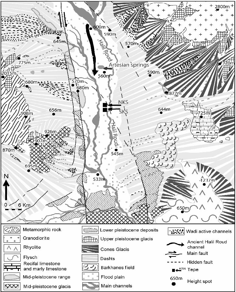
Topography and climate. Between Jiroft and the entry to the Jazmurian basin, the average altitude of the valley bottom is 550 m. High mountains outline this valley: the Jebal Barez massif to the east peaks at almost 4000 m; the Sardouiyeh to the west reaches almost 3000 m, and Mount Hezar to the north has a summit of 4420 m. Downstream of Jiroft, two principal channels drain the alluvial plain, which is 7 km wide: the Halil Rud on the eastern edge and a drain that receives water from several wadis on the western edge and flows together with the Halil Rud in the south of the valley. The valley bottom and the mountain sides are connected through massive flat stretches of alluvial deposits (Pers. dašt; q.v.). They are 7 to 12 km wide, slightly inclined (1-1.5 degrees), and imposing torrential alluvial fans dominate their mountain sides. Small mountain chains, easily noticeable in the landscape (Figure 2), line the connection between the alluvial plain and the western dašt.
The available climatic data pertain to Kerman, the nearest city which is situated at an altitude of 1649 m and 150 km further north. At this altitude, the annual rainfall ranges from 168 to 203 mm total. Precipitations are concentrated between January and March, while the drought effectively lasts from April to November. The annual temperature averages between 16 and 17.5° C, with a maximum summer temperature of 43° C. The water management service of Jiroft estimates for the Halil Rud valley that the average annual precipitation is 375 mm in the mountains north of Jiroft and 125 mm in the south, in the Jazmurian depression. In other words, the Jiroft basin is situated in a transitional zone between the semi-arid to the north and the arid to the south, and the transitional zone is very sensitive to the consequences of climatic fluctuations. But the impact of the arid fluctuation between 2200 and 1900 B.C.E. is unclear (Roberts and Wright), even though this fluctuation is confirmed for all of the Middle East and Western Asia and seems to coincide with the end of occupancy of the Bronze Age settlements in the Jiroft basin.
Geology and mineral resources. The tectonic collision in the Zagros (Boulin; Alavi) and its subduction under the Makran (Byrn) led to the creation of the Jiroft basin as a combination of a right-slip fault system (Sabzevaran system to the west, Jiroft system to the East), which is positioned north to south with compressive relays from the east and west (Regard). This intermediary position between the systems of Zagros and Makran accounts for the lithological repartition that is visible in the catchment area (i.e., drainage area) of the Halil Rud. To the west, the massif is essentially composed of metamorphic rocks, such as shale, marble, and chlorite. Crystalline (i.e., diorites, granodiorites, granites) and volcanic (i.e., andesite, volcanic ashes) dominate in the east. In the southeast, one finds some limestone massifs. Touching the Jazmurian depression, a large flysch massif rests in discordance with a rhyolitic massif (Figure 2).
This geological context is crucial for understanding the distribution of mineral resources around the Jiroft basin. There is copper (q.v.) in the east, at Jebal Barez, zinc to the west, chlorite (q.v.) and locally gold (q.v.) in the southwest, while the pebbles of the Halil Rud and the dašts offer in abundance a complete sampling of the lithology in the river’s catchment area. All of these can be found within a maximum radius of 100 km around the sites of the Konar Sandal.
The natural hazards of seismic activity and flood. During the Holocene the morphogenesis in the Halil Rud valley is active, notably because of neotectonics and especially of the fluvial dynamic. The currently active tectonic dynamics have a strong seismicity as a corollary. The recorded earthquakes (Heydari) over the past 150 years show that the latter are highly concentrated in the Zagros range and characterized by a high frequency and an average magnitude of 4 on the Richter scale. In the Jiroft basin, six earthquakes have been observed, five of which had an epicentre along the Sabzevaran fault system. On the field, many indications indicate the Quaternary activity of these faults. First, the Sabzevaran geological map indicates an average lateral displacement of 3 to 3.5 mm per year and a maximum subsidence of 250 m during the Quaternay, which results in 0.1 mm per year. In his study of the Sabzevaran fault system further to the South, Regard notes the lateral displacement of the fault line at 3 mm per year. Tatar considers it as still active. On the field, the series of small massifs, caused by formations dating back to the ancient Quaternary that are regularly aligned along the Sabzevaran fault, allow for picturing the displacement.
The Halil Rud valley between Jiroft and the Jazmurian depression corresponds to a pull-apart graben in activity since the Plio-Miocene era. From the Eastern dašt two Cretaceous limestone massifs emerge. On the Quaternary scale, the sporadic torrential flash floods that characterize the wadis constitute the most efficient morphological agent. This is particularly true for the flood plains of the Halil Rud during the Holocene (Fouache).
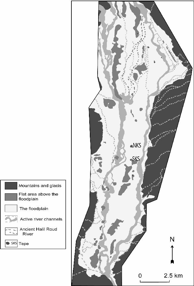
The Halil Rud has the hydrological regime of a wadi: It is characterized by discontinuous and intermittent floods during the winter months, with a very high interannual variability. But the breadth of its catchment area, the presence of snow upstream, and the occurrence of major flash floods caused by precipitations of high intensity, which rarely last more than an hour but can be catastrophic, explain that the fluvial beds can be affected and abundant water resources are available on the plain. The data of the meteorological station at Bam provide estimates, such as the following: an intense rainfall of 64 mm per hour for a duration of 40 minutes is an event that occurs every 100 years; that a rainfall of 56 mm per hour lasting the same time occurs every 50 years; that 36 mm per hours corresponds to one rainfall every 10 years; and that a rainfall of 15 mm per hour occurs every 2 years. The examination of aerial photographs reveals an active, braided stream system that allows for charting with precision the channels and the flood plain of the Halil Rud (Figure 3). Below the terrace on which the archeological sites are located, at a maximum of 1 to 2 m above the flood plain, two levels with traces of stream, the flood plain itself and channels, are visible. The aerial photographs also reveal a paleo-channel, indicating that the Halil Rud overtook the western drain the before the river moved into its present channel at a still undetermined time. The latest large flood event that submerged the whole flood plain occurred in January 1992. The water table is very close to the surface at a depth of less than two meters locally. Naturally put under 8 bars of pressure, the water table even creates artesian wells that sprang naturally in the plain halfway between Jiroft and Konar Sandal until 2001, when they were caught for irrigation and for bottling as mineral water. The main characteristic of this water is an increasing salinity from the upstream towards the downstream, so that it ceases to be potable south of Konar Sandal. The high presence of gypsum in the Neogene formations explains this salinity. The salinitiy, in turn, explains the abundance of tamaris, a halophile species of trees commonly found in marshy areas.
If 4000 to 5000 years ago the seismicity constituted the same risk as today, it did not prevent the imposition of human developments, as witnessed by the recently uncovered archeological vestiges. The floods of the Halil Rud did not constitute a repulsive factor either. Since these societies were careful to settle on the high points of the alluvial terraces, floods may have even constituted a favorable element of human settlement.
A small Mesopotamia. During a major flood event, at the downstream of the Jiroft alluvial fan, the flood plain extends to a maximum width of 7 km, while the water level does not exceed 5 m. If a map of the archaeological sites is superimposed on a map of the Halil Rud flood plain (Figure 3), which indicate zones above water during major floods, they show a perfect correlation. It is equally puzzling to notice that at the time of the last major flood, which occurred in the valley in 1994, the inhabitants of the villages of Konar Sandal sought refuge on the tepe for three days, while at the downstream the water remained high for yet another ten days. Since the floods bring silt that renews the soil, while cleaning the soil saturated with salt, they have a doubly beneficial role. It is important that the date trees, which appear in abundance on the vases of Jiroft and today still form vast plantations, are perfectly adapted to these hydrological and edaphic conditions. The true advantage of this semi-arid region lies in an abundant water table, close to the surface and independent of short drought-cycles.
The presence of this water table explains the abundance of date trees, which were the possible mainstay of an original Neolithic development. Since the Middle Ages, all geographers and travelers mentioned that the valley was fertile and appeared as a small Mesopotamia. Ebn Ḥawkal described Jiroft’s environs as a fruitful neighborhood where the crops of both hot and cold regions were grown. At that time the city’s main exports were indigo, cardamom, sugar-candy, and dušāb, syrup made from grapes or dates, while the surrounding area produced dates, nuts, and oranges. Marco Polo’s observations are similar. Today the construction of an irrigation system and green houses on the dašts enrich the agricultural production with important cucumber and tomato harvests. Date trees may well be endemic to the area (Rossignol-Strick). Along the thalwegs, in the higher regions of the dašts, some acacias, well adapted to drought, can be found. Grazing and anthropic pressure caused the forests long ago to disappear. They were already mythic at the time of Ḥamd-Allāh Mostawfi (ca. 1281-ca. 1344; q.v.) who mentioned that lion-haunted forests had originally surrounded the town (p. 140; tr. 139), though in his day there were just immense palm groves. Only shreds of juniper forest subsist at about 3000 m altitude.
It is not yet proven whether the present archeological map correctly reflects human settlement in the Jiroft valley during the Bronze Age because the lower parts of the archeological sites may have been damaged by floods or fossilized by alluvium. The geophysical study conducted at South Konar Sandal (Fouache) shows a major discontinuity between 4 and 10 m depth, which seems to correspond with the level of the first human settlement on this site. Although the age of this site is not yet determined, it is undoubtedly older than Bronze Age, because the Halil Rud river was running west of South Konar Sandal and the necropolis located between the sites of North and South Konar Sandal is today cut in two by the river’s channels. But the large urban archeological sites, like those of South and North Konar Sandal, have most certainly already subsisted in this landscape, though not in their full extension. The small rural sites, which are located in the flood plain, are buried under several meters of alluvium, probably 2 to 3 m covering.
Bibliography:
Travel accounts: Ebn Ḥawqal, Ketāb ṣurat al-arḍ, ed. J. H. Kramers, BGA 2, 2nd ed., repr., Leiden, 1967.
G. Le Strange, Lands of the Eastern Caliphate: Mesopotamia, Persia, and Central Asia, from the Moslem Conquest to the Time of Timur, Cambridge, 1905. Moḥammad b. Ebrāhim, Histoire des Seljoucides du Kermán, ed. M. Th. Houtsma, Recueil de texts relatifs à l’histoire des Seljoucides 1, Leiden, 1886.
Ḥamd-Allāh Mostawfi, The Geographical Part of the Nuzhat-al-Qulūb, ed. G. Le Strange, Leiden, 1915; English tr. by G. Le Strange, Leiden, 1919.
Moqaddasi, Aḥsān al-taqāsim fi maʿrifat al-aqālim, ed. M. J. de Goeje, BGA 3, repr., Leiden, 1967, pp. 461, 466, 470.
M. Polo, The Book of Ser Marco Polo, the Venetian, Concerning the Kingdoms and Marvels of the East, tr. by Henry Yule, 3rd ed., 2 vols., London, 1903.
P. Schwarz, Iran im Mittelalter nach den arabischen Geographen, 9 parts, Leipzig, 1896-Stuttgart, 1936, repr., Hildesheim, 1969; various repr., volume count differs.
Studies. M. Alavi, “Tectonics of the Zagros Orogenic Belt of Iran: New Data and Interpretation,” Tectonophysics 229, 1994, pp. 211-38.
J. Boulin, “Structures in Southwest Asia and Evolution of the eastern Tethys,” Tectonophysics 196, 1991, pp. 211-68.
D. E. Byrn et al. “Great Thrust Earthquakes and Aseismic Slip along the Plate Boundary of the Makran Sabduction Zone,” Journal of Geophysical Research 97 (B1), 1992, pp. 449-78.
E. Fouache et al., “Dynamiques géomorphologique dans la vallée de l’Halil Roud (Iran, région de Jiroft): Perspectives géoarchéologiques,” Paléorient 31, no. 2, 2005, pp. 107-22.
M. Heydari et al., “The Information of Bam Earthquake and its Aftershocks I (2004),” available on the internet: www.iiees.ac.ir/English/bank/Bam/Bam_report_english_aftershock.html (accessed May 23, 2007) A. Miquel, “al-Muḳaddasī,” EI ², VII, pp. 492-93.
Y. Madjdzadeh, ed., “Jiroft: Fabuleuse découverte en Iran,” special issue, Dossiers d’Archéologie, no. 287, Oct. 2003.
J. Perrot, “Jiroft: Un nouveau regard sur les origines de la civilisation orientale,” Dossiers d’Archéologie, no. 287, Oct. 2003, pp. 2-3.
H. Pittman, “La culture de l’Halil Roud,” Dossiers d’Archéologie, no. 287, Oct. 2003, pp. 78-87.
N. Roberts and H. E. Wright, “Vegetational, Lake-Level, and Climatic History of the Near East and Southwest Asia,” in Global Climates since the Last Glacial Maximum, ed. H. E. Wright, Minneapolis, 2003, pp. 194-220.
V. Regard, Variation temporelle et spatiale de la transition subduction-collision: Tectonique de la transition Zagros-Makran (Iran) et modélisation analogique, Ph.D. diss., Université d’Aix-Marseille III, 2003; available as pdf-file on the internet: http://tel.archives-ouvertes.fr/tel-00003777 (accessed 20 April 2007).
M. Rossignol-Strick, “Climat et végétation sur le plateau iranien à l’aube des temps historiques,” Dossier d’arché-ologie, no. 287, Oct. 2003, pp. 5-17.
M. Tatar et al., “The Present-Day Deformation of the Central Zagros from GPS Measurements,” Geophysical Research Letters 29, no. 191/927, 2002, doi: 10.1029/2002GL015427.
(Eric Fouache)
Originally Published: December 15, 2008
Last Updated: April 17, 2012
This article is available in print.
Vol. XIV, Fasc. 6, pp. 648-653