

FĀRS
i. Geography
Evolution of the geographical concept. The name of Fārs is undoubtedly attested in Assyrian sources since the third millennium B.C.E. under the form Parahše. Originally, it was the “land of horses” of the Sumerians (Herzfeld, pp. 181-82, 184-86). The name was adopted by Iranian tribes which established themselves there in the 9th century B.C.E. in the west and southwest of Urmia lake. The Parsua (Pārsa) are mentioned there for the first time in 843 B.C.E., during the reign of Salmanassar III, and then, after they migrated to the southeast (Boehmer, pp. 193-97), the name was transferred, between 690 and 640, to a region previously called Anšan (q.v.) in Elamite sources (Herzfeld, pp. 169-71, 178-79, 186). From that moment the name acquired the connotation of an ethnic region, the land of the Persians, and the Persians soon thereafter founded the vast Achaemenid empire. A never-ending confusion thus set in between a narrow, limited, geographical usage of the term—Persia in the sense of the land where the aforesaid Persian tribes had shaped the core of their power—and a broader, more general usage of the term to designate the much larger area affected by the political and cultural radiance of the Achaemenids. The confusion between the two senses of the word was continuous, fueled by the Greeks who used the name Persai to designate the entire empire. It lasted through the centuries of Arab domination, as Fārs, the term used by Muslims, was merely the Arabicized version of the initial name.
The use of the term in the broad sense coincided with the rise of the Achaemenid empire. Before Darius I, the satrapy of Persia (OPers.: Pārsa) comprised all of southeastern Persia, and, particularly, present-day Kermān (Herzfeld, pp. 289, 298-99). Herodotus’ text (1.125), which included the Germanioi (q.v.) among the six tribes of Persia, is a reminder of this situation, which ended after the recasting of the satrapies following the uprising of 521 when countries of non-Iranian populations in the east, the Outioi (Yautiyā), the Mukoi (Makā), and people from the Persian Gulf islands (Herzfeld, pp. 300-301), were excluded. Parsā, exempt from taxes and thus not included in the list of the twenty satrapies by Hecataeus (Herzfeld, pp. 295-97), from then on acquired the limited meaning, which lasted through the administrative divisions of the Sasanian and caliphate eras until the present time (the ostān of Fārs). The broad sense, however, never completely vanished. Thus, the Arab geographiers included even such districts as Marv as part of Fārs (Bakrī, ed. Wüstenfeld, II, p. 526), while Ebn Ḵordāḏbeh (p. 62) spoke of the “border between Fārs and Sind.” Likewise, Yazd was included in Fārs under the caliphate before being separated from it in the Mongol period (Nozhat al-qolūb, p. 113, tr., p. 112; Le Strange, p. 249; Schwarz, Iran, pp. 2-3); and that was still the understanding of Mostawfī in 1340 (Nozhat al-qolūb, p. 113, tr., p. 112). The restricted meaning, such as it was, came gradually to be reduced even more, essentially by exclusion of the Persian gulf coastal strip. Under the caliphate, Fārs extended from Mahrūbān on the Persian Gulf in the west to Ḥeṣn Ebn ʿOmāra (Eṣṭaḵrī, p. 135) or Sūrū (Moqaddasī, p. 427) on the Strait of Hormuz in the east, or even from Qomeša (present-day Šahreżā) south of Isfahan to the island of Qays (present-day Kīš; Nozhat al-qolūb, loc. cit.).
If the limited meaning has succeeded in maintaining and entrenching itself in spite of the influence of the broader meaning, it is because it rested in fact on original natural bases which were favorable to the development of an individualized geographical concept through the grouping of regions of complementary climatic zones. The Arab geographers and Mostawī had already affirmed an internal division of Fārs between warm regions (jorūm, garmsīr) and cold regions (sarūd, sardsīr), as is evident in their regional and local descriptions. This natural division was also expressed in the diverse names applied to the lands and administrative divisions. Thus in the 19th century it was composed of an administration of the “land of ports” (bandarāt), whose jurisdiction extended from the head of the Persian Gulf to the border of British Baluchistan. Under the plan of administrative reorganization initiated by Demorgny (1913), a governate (welāya) was proposed for the Daštī and Daštestān (country of plains) which would occupy part of the lowlands (Demorgny, map of the “Nouvelles divisions administratives”). The end result is the present-day configuration, which, with the provinces (ostāns) of Bušehr and Hormozgān, reflects the gradual development of the ports of Bušehr and Bandar ʿAbbās (qq.v.) through contemporary and modern times, and the individualization of their spheres of influence, thus excising Fārs of a large part of its coastal strip. Alhough occasionally there have been trends toward reshaping a vast administrative whole (for example, under the 1938 reform Fārs, as the seventh ostān, included Lārestān, Bušehr, and even an eastern fringe of Ḵūzestān). The geographical concept of Fārs nowadays includes mostly the cold highlands, even though the ostān of Fārs still comprises expansive stretches of lowland.
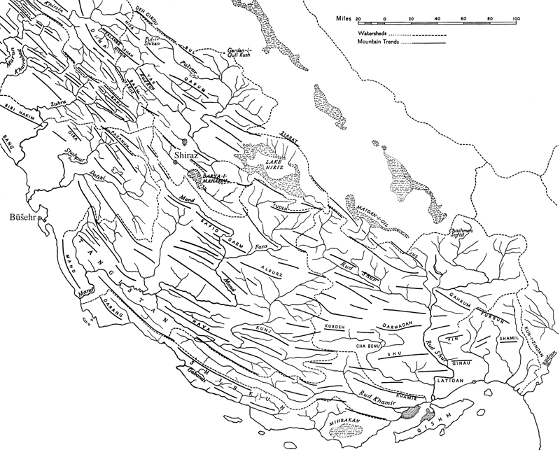
Natural geographic zones. This evolution reveals an irrefutable geographical fact which is founded on physical bases. The heart of Fārs is comprised of the highland basins. East of the meridian of Bušehr and Isfahan, the Zagros mountain chains, which gradually decrease in altitude toward the southeast but still mostly remain above 2,000 and sometimes 3,000 m, grow further apart from each other, while the folds, aligned strictly northwest-southeastward until then, straighten back gradually in a west-northwest east-southeastward direction, eventually shifting to a west- eastward direction in the Lārestān and the Bandar ʿAbbās region. Between them lie high basins, situated between 1,000 and 1,800 m: the plains of Marvdašt, Neyrīz, Lār, Jahrom, Eṣṭahbānāt, Kavār, Fīrūzābād (qq.v.), etc., which have been the historic site of settlement of the Persians and give Fārs its geographic originality when compared to the western Zagros (the lands of the Baḵtīārī, q.v.), where the mountain chains, much closer to each other, are separated only by narrow, longitudinal valleys. Two of the basins are without drainage, and lakes of high salt content lie in their bottoms: the Daryāča-ye Mahārlū, to the southeast of Shiraz, and that of Neyrīz (see BAḴTAGĀN), where several lakes separate during periods of low tide (lakes of Neyrīz, Tašk, and Baḵtagān) and merge when the water level goes up. The level of the lakes varies depending on the season, and salt from them is exploited commercially. The Daryāča-ye Mahārlū (whose maximum span today is 220 km2) was still connected to the Persian Gulf until the recent Pleistocene, before being separated from it by a scattering of gravel during a pluvial episode. These high basins, already relatively dry in the northwest (average rainfall: 348 mm per year in Marvdašt; 340 mm in Shiraz), become quite arid in the southeast to the point that rain-watered agriculture is no longer possible.
Toward the south, the chains of the Zagros subside as does the level of the basins, and runoff drainage becomes the norm. Precipitation also decreases with altitude, falling to below 200 mm annually in the southeastern region, as the land becomes gradually more and more desolate. This area is known as Tangestān (land of ravines), which gives way along the littoral of the Persian Gulf to highly irregular coastal plains (the Daštestān), sometimes fifty kilometers wide as in the north of Bušehr but which become gradually narrower and more fragmented toward the east. Immediately southeast of Bušehr, on the Tangestān coast, they diminish to only two or three kilometers in width, broadening only at the mouths of the small coastal rivers.
This layering of relief zones is accentuated by contrasts of temperature and the vegetal landscape, which are at the heart of the regional differences recognized quite clearly in the popular mind (Kortum, pp. 16-22). The high basins are collectively “cold lands” (sardsīr), the summer quarters of nomads as well as areas of rain-watered agriculture. However, the highest plains of the interior sector, and the elevated terrains which surround them, are already called sarḥadd (uppermost highlands), where cultivation is no longer possible. The Tangestān and the Daštestān are for the most part “warm lands” (garmsīr), the winter quarters for nomads and the exclusive domain of irrigated agriculture. Between the cold lands and the warm lands, however, there is an intermediate concept, that of the moʿtadel (temperate region), recognized by the Qašqāʾī (Garrod, 1946a, p. 35), and already noted by the Arab geographers (Eṣṭaḵrī, pp. 135-37; Moqaddasī, p. 421; Ebn Ḥawqal, pp. 287-88 Schwarz, Iran, pp. 11-12). An interesting demarkation line between these two areas is that of date palm cultivation, which is found, according to location, in areas between 1,200 and 1,500 m above sea level and progressively higher toward the east (1,200 m in Ḵafr, 100 km southeast of Shiraz; 1,380 m in Fasā; Bobek, 1952, p. 76). The pomegranate tree, which grows at altitudes as high as 1600 m, is fairly characteristic of the temperate zone, whereas the grapevine, thanks to refined methods, grows in cold lands as high as 2,200 m. The natural vegetation, composed of oak forests (nowadays very sparse) in the highland chains and patches of pistachio-almonds trees in the high basins, turns into a brushwood of jujube-trees (Zizyphus sp.) in the higher levels of the garmsīr, and to a savanna of acacias below 1,000 m of altitude (Bobek, 1951, p. 38).
Nomadism and settlement. Between these zones, dynamic human and pastoral relations have developed which give Fārs its primary geographic unity. In contrast to the western districts of the Zagros, where the powerful confederation of the Baḵtīārī achieved ethnic unity, the tribes of Fārs are broken down in many different ethnic groups (Demorgny, Monteil): The Qašqāʾīs (Marsden, Oberling, 1974) are Turcophones numbering 17,000 tents in 1972 (Ehlers, p. 398) who winter in the regions of Fīrūzābād and Kāzerūn and summer to the north of Shiraz in the western region, and whose seasonal migrations sometimes covers 200 to 300 km. The Ḵamsa (q.v.) or “the five,” located more to the east, have equally great migrations, wintering north of Lār and Jahrom and summering northeast of Shiraz. They are a mixed confederation joining Arabophone tribes (Jabbāra and Šaybānī), Turkophones (ʿAynalū, Bahārīn, and Nafar, qq.v.), and Persophones (Bāṣerī, q.v.; Barth, 1964), which numbered 16,000 to 17, 000 tents at the beginning of the 1960s. To the west, in the districts of Yāsūj and Behbahān, are the Mamasanī and the tribes of Kūhgīlūya, numbering several thousand tents, speaking Lorī, and whose movements, much shorter in length, hardly covers more than some dozen kilometers between summer and winter. The territories of these various ethnic groups overlap, as distinct groups often succeed each other over the same course throughout the year following a very precise annual rhythm, which places, in a given period, the Turcophones highest in altitude, the Arabophones lowest, and the Persophones in the middle (Barth, 1959-60), depending on their respective affinities for more or less cold or warm temperatures.
The dominance of these great nomadic groups, which goes back to the nomadization of the Zagros following the Turko-Mongol invasions, has nevertheless translated itself into a steady and gradual process of sedentarization affecting in particular impoverished nomads who have lost their cattle, to the extent that most of the rural population of Fārs originated in this way (Barth, 1964, pp. 116-21). Hamlets and villages have thus multiplied around the few remaining nuclei, especially during this century (see the reproduction of a historical stage of the habitat, mapped in detail, in Kortum, figs. 2 and 3). Pressure from the government has also contributed to the process, with periods of forced settlement under Reżā Shah (end of the 1930s) and strong pressure exerted on the Qašqāʾī again after 1963. The tremendous progress in irrigation systems through the use of water ducts (such as the great Dārīuš Dam on the river Kor, which allowed for the cultivation of some 100,000 ha in the Marvdašt plain), subterranean channels (qanāt), and more recently, mechanical pumps in the central part of basins, has facilitated this development (Kortum, figs. 6, 7, 12). The plain of Marvdašt, which at the beginning of this century was largely used by the Qašqāʾīs as winter settlement, nowaydays has become merely a thoroughfare. A commercial agriculture has thus been instituted, with an industrial base: sugar beets (for the sugar refineries at Marvdašt (1935), Fasā (1954), Kavār, (1962), and Mamassanī (1966)), cotton, and fodder, while citrus orchards and date palms continue to expand in the garmsīr.
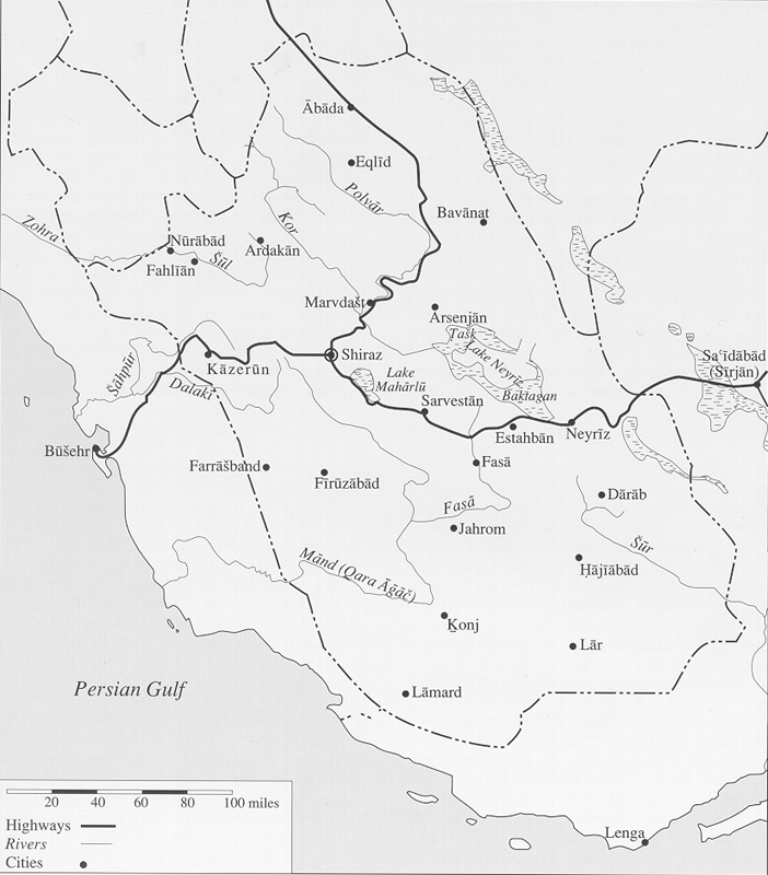
Roads and cities. Parallel with the nomadization of the region, there was also the development of a whole network of cities which expressed by their presence another geographic function of Fārs, that of a transit route par excellence between the Gulf littoral and the high Iranian plateau. The cluster of the high chains of the Zagros is not easily passable further to the west; east of the meridian of Bandar ʿAbbās, the desert coast of the Makrān only gives access to desolate and sparsely populated stretches. But Fārs, with its airy relief, and in spite of the harshness of its precipitous slopes rising to the highland, offers numerous routes, which at least as early as the 9th century gave access to the great cities of Isfahan, Yazd, or Kermān from Sīrāf, Qays, or Hormuz (Le Strange, pp. 295-98), and then in modern times from Bandar ʿAbbās or Bušehr. Kermān is thus accessible through Sīrjān from Bandar ʿAbbas, and the Shiraz basin either through Dārābgerd and Fāsā, or Lār and Jahrom with an alternative route via Fīrūzābād. From Bušehr, the Shiraz basin, Yāsūj, and Isfahan can be accessed via Kāzerūn. Several routes lead to Isfahan from Shiraz, either directly through the mountains by way of Yāsūj, Semīrom and Šahreżā (Qomeša), or by way of Abāda (q.v.), with a detour through the northwestern foothills of the mountain ranges, which traditionally constituted a safer route by providing cover from nomadic brigands.
There are thus two distinct types of cities in the Fārs. The most important ones are cities which serve as transit points and which, especially near Tangestān and the highland, essentially serve as storage depots and relay stations, arranged in a regular formation from east to west: Lār, Jahrom, Fīrūzābād, and Kāzerūn. The highland small towns, which before anything else have a central function with regard to their respective basins, are not as active and have not grown as fast, with the exception of Marvdašt, whose population grew past the 50,000 mark as early as 1976 thanks to the agricultural development of its plain. Since the Achaemenids, however, this area has always been the seat of a major center, first with Pasargadae, Persepolis, and Eṣṭaḵr, and then, during the Muslim period, with Shiraz, toward which the routes to Isfahan and Yazd converge .The city, which served as the capital of Persia for a while under Karīm Khan Zand (1163-93/1750-94), has always been the administrative center of the region and has striven to regulate the flow of trade as well as the movement of nomads, maintaining uncertain relations with the latter. More often than not, it has been in conflict with the Qašqāʾī tribe, which was established in the area as early as the Safavid era and whose leaders always held temporary residences in the city, but which often violently asserted its hostility against the city and its governors, sometimes actually instituting real sieges (Oberling, 1974, esp. pp. 56-58, 91-92). However, it was the merchants of Shiraz, in order to assure the safety of caravans, who were the organizers at the beginning of this century of the confederacy of the Ḵamsa (Barth, 1964, pp. pp. 86-89; Oberling, p. 114) thus expressing the determinant role of the city in the overall shaping of the regional landscape.
Bibliography (for cited works not given in detail, see “Short References”):
Abu’l-Fedā, Taqwīm al-Boldān, ed., M. Reinaud, Paris, 1840, pp. 321-31; Pers. tr. ʿA.-M. Āyatī, Tehran, 1349 Š./1970, pp. 367-85.
Ī. Afšār Sīstānī, Īlhā, čādornešīnān wa ṭawāyef-e ʿašāyerī-e Īrān, 2 vols., Tehran, 1366 Š./1987, II, pp. 602-72.
Abū ʿObayd Bakrī, Ketāb al-masālek wa’l-mamālek, 2 vols., ed. H. F. Wüstenfeld, Göttingen and Paris, 1876-77.
F. Barth, “The Land Use Pattern of Migratory Tribes of South Persia,” Norsk Geografisk Tidsskrift 17, 1959-60, pp. 1-11.
Idem, Nomads of South Persia, Oslo, 1964.
W. Barthold, An Historical Geography of Iran, tr. S. Soucek, Princeton, N. J., 1984.
M. Bāvar, Kūhgīlūya wa īlāt-e ān, Tehran, 1324 Š./1945.
L. Beck, The Qashqaʾi of Iran, New Haven and London, 1986.
H. Bobek, Die Natürlichen Wälder und Geholzfluren Irans, Bonner Geographische Abhandlungen8, Bonn, 1951.
Idem, “Beiträge zur klima-ökologischen Gliederung Irans,” Erdkunde 6, 1952, pp. 65-84. R. M. Boehmer, “Zur Lage von Parsua im 9 Jahrhundert vor Christus,” Berliner Jahrbuch für Vor- und Frühgeschichte 5, 1965, pp. 187-88.
Cambr. Hist. Iran I, index.
A. J. Christian, A Report on the Tribes of Fars, Simla, 1919.
J. I. Clarke, The Iranian City of Shiraz, University of Durham Research Papers 7, Durham, England, 1963.
Curzon, Persian Question II, pp. 64-236.
G. Demorgny, “Les Réformes Administratives en Perse. Les tribus du Fars,” RMM 22, 1913, pp. 83-150; 23, 1913, pp. 3-108.
Ebn Balḵī. Ebn Ḥawqal, pp. 260-304; tr. Kramers, pp. 259-99.
E. Ehlers, Iran: Grundzüge einer geographischen Landeskunde, Wissenschaftliche Länderkunden18, Darmstadt, 1980.
Eṣṭaḵrī, pp. 96-158; anonymous Pers. tr., ed. Ī. Afšār, Tehran, 1347 Š./1968, pp. 95-137; Pers. tr. Moḥammad b. Asʿad Tostarī, ed. Ī. Afšār, Tehran, 1372 Š./1994, pp. 87-160.
Fasāʾī, ed. Rastgār. O. Garrod, “The Nomadic Tribes of Persia Today,” Journal of the Royal Central Asiatic Society 33, 1946a, pp. 32-46.
Idem, “The Qashqai Tribe of Fars,” Journal of the Royal Central Asiatic Society 33, 1946b, pp. 293-306.
H. Gaube, Die südpersische Province Arrağān/Kūh-Gīlūyeh von der arabischen Eroberung bis zur safawidenzeit, Vienna, 1973.
E. Herzfeld, The Persian Empire. Studies in Geography and Ethnography of the Ancient Near East, ed. G. Walser, Wiesbaden, 1968.
Ḥodūd al-ʿĀlam, ed. Sotūda, pp. 11-13, 31-32, 130-36; tr. Minorsky, pp. 52-55, 65-66, 126-31.
Kayhān, Joḡrāfīā II, passim; III, pp. 214-43 and passim.
G. Kortum, Die Marvdasht-Ebene in Fars: Grundlagen und Entwicklung einer alten iranischen Bewässerungslangdschaft, Kieler Geographische Schriften 44, Kiel, 1976.
Le Strange, The Lands, pp. 248-98.
K. Lindberg, Voyage dans le Sud de L’Iran, Lund, 1955.
Lorimer, Gazeteer. D. Marsden, “The Qashqaʾi Nomadic Pastoralists of Fars Province,” in J. Allgrove, ed., The Qashqāʾi of Iran, Manchester, England, 1976, pp. 9-22.
Ministère de l’Intérieur, Rapport du Ministère de l’Intérieur sur le Fars, Tehran, 1913.
V. Monteil, Les tribus du Fârs et la sédentarisation des nomades, Paris and The Hague, 1966.
Moqaddasī, pp. 420-59.
S. Nejand, “Geologie und Hydrologie des Maharlu-Sees und seine Umgebung bei Shiraz/Iran,” Ph.D. diss., Aachen, 1972.
Nozhat al-qolūb, ed. Le Strange, pp. 112-39; tr. Le Strange, pp. 111-38.
P. Oberling, “The Turkic Tribes of Southwestern Persia,” Ural-Altaische Jahrbücher 35/B, 1963, pp. 164-80.
Idem, The Qashqaʾ’i Nomads of Fars, The Hague and Paris, 1974.
Razmārā, Farhang VII. A. T. Wilson, The Persian Gulf, London, 1928.
Schwarz, Iran, pp. 43-211.
(Xavier de Planhol)
Originally Published: January 1, 2000
Last Updated: January 1, 2000