

BĀḠ
ii. General
In Iranian agriculture, the word bāḡ, though usually translated as “garden,” means more precisely an enclosed area bearing permanent cultures—i.e., all kinds of cultivated trees and shrubs, as opposed to fields under annual crops (zamīn-e zīr-e kešt or kešt-e sālāna)—in land-use statistics (the Village Gazetteer of 1966) as well as in everyday speech. It includes orchards (bāḡ-e mīva), vineyards (bāḡ-e mow), olive groves (bāḡ-e zeytūn), tea plantations (bāḡ-e čāy), but not vegetable gardens (sabzīkārī or ṣayfīkārī).
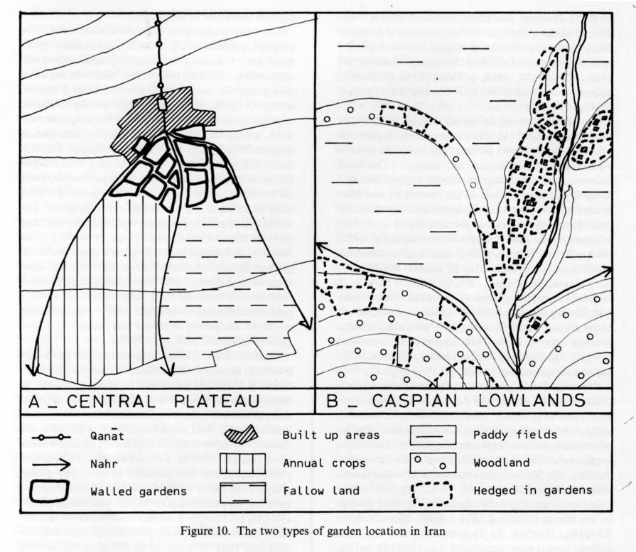
Figure 10. The two types of garden location in Iran.
The most conspicuous and best-known form is the irrigated gardens of old sedentary settlements (piedmont oases and mountain villages) in interior Iran and Afghanistan (Planhol, 1964, p. 96). Whatever the water source may be (qanāt, nahr diverted from a stream, spring or well), the gardens are usually clustered together close to the head-race of the irrigation network, around the village or just below it (examples in English, 1966, pp. 53-54; Berthaud, 1968, p. 300; Balland, 1974, p. 177; Bazin, 1974, p. 45 etc.). This location allows to irrigate them as frequently as possible, every six to twelve days in the hot season, whereas the fields lying underneath are much less often irrigated. The small or large plots are generally enclosed with high mud walls, or terraced in hilly areas, and served by a dense network of footpaths and irrigation channels. Most gardens are not cultivated between the trees, but some are sown with grass or alfalfa or include small patches of vegetables. Wheat and other staple crops are sown in gardens only in mountain settlements having too scarce cropland. Temporary dwellings may be built in remote gardens (Balland, 1974, pp. 178-79).
Gardens of arid Iran and Afghanistan can be divided into three climatic levels (called Höhenstufen by Ehlers, 1980a, p. 225): 1. Hot lands of the garmsīr, within the limit of date-palm cultivation, where the main crops are dates and citrus fruit, as in Bam and Narmāšīr (Fecharaki, 1976). 2. Still warm lands of the piedmonts and interior basins, up to about 1,500 meters high, as around Qom (Bazin, 1974) or Kermān (English, 1966), with pomegranate and figs, pistachio in the driest places, vineyards in better watered areas, and olive trees in a quite limited district around Rūdbār and Manjīl (Bazin, 1980, II, pp. 113-15). 3. Colder level (sardsīr) of valleys and intramontane basins, e.g., in central Alborz (Hourcade and Tual, 1979, pp. 59-61 and map 19), or West and East Azerbaijan (respectively Berthaud, 1968, pp. 315-17, and Bazin, 1980, II, pp. 98-101). The proportion of cultivable land devoted to gardens is low on average: about 10 percent around Kermān (English, 1966), but varies considerably, both regionally and locally. The highest proportion occurs in villages or districts having the best water resources, such as the central part of the Isfahan oasis (Planhol, 1969, p. 394).
Settlements of newly sedentarized nomads can often be recognized by the lack of or the very small size of their gardens, e.g., the Paṧtūn villages south of Ḡaznī (Balland, 1974, pp. 176-77).
A quite different pattern occurs in the Caspian provinces of Iran (Ehlers, 1971): there the low-lying irrigable lands are exclusively devoted to rice cultivation, and the gardens, always rain-fed, appear to be a part of the “pluvial lands” (Bazin, 1980, I, p. 146) stretching on foothills or alluvial embankments (see aerial photographs nos. 1 and 2 in Sahami, 1965). These pluvial lands are a mosaic of small plots surrounded by hedges, where gardens intermingle with scattered houses, wheat and tobacco fields, meadows, and remnants of forests. Besides all kinds of temperate fruit species, three more specific crops occupy extensive areas in some specialized districts: mulberry trees (the leaves of which are gathered to breed silkworms) in western and eastern Gīlān; tea in Fūmanāt and especially south of Lāhījān (Ehlers, 1971); citrus fruit in easternmost Gīlān and western Māzandarān (Asif, 1977).
Gardens differ also from fields with respect to their socio-economic status. In the traditional feudal-like agrarian society, the landlords could exploit their bāḡs in several ways (Lambton, 1953, pp. 323-25): they could be worked by the same sharecroppers as the fields, but the tenants often paid a heavier share to the landlord, for instance 3/4 instead of 2/3 in some villages around Qom (Bazin, 1974, p. 56), and generally paid it in cash and not in kind; other gardens were given to specialized gardeners (bāḡdār or bāḡbān), with whom either the produce or the trees were shared by half (Lambton, 1969, pp. 197-98); some were directly cultivated by the landlord hiring wage laborers (rūz mozd), or leased to a third person, particularly around large cities. In some cases, a peasant might have planted trees that became his own property (aʿyān), with rights distinct from the land (ʿarṣa) belonging to the landlord (Lambton, 1969, p. 26) or even possess a small garden in full property.
The gardens were mostly excluded from expropriation in the three successive stages of the Iranian land reform (Lambton, 1969, pp. 68 and 221; Ehlers, 1979, pp. 444-45), unless the peasants possessed the aʿyān. In many oases of central Iran, all the landlords’ interests and efforts focused upon gardens, something which led to a more intensive exploitation of existing gardens, while the surrounding fields distributed to their former tenants fell into decay, owing to an insufficient supply of water (Ehlers, 1980b). On the other hand, the large agro-business estates created after 1970, often in connection with dams and large irrigation schemes, paid little attention to gardening, except for a few mulberry plantations in the Caspian lowlands. More and more inhabitants of large cities such as Tehran have bought gardens in order to build summer dwellings or tourist accommodations in a pleasant environment (Hourcade, 1979, p. 132).
Bibliography:
M. I. Asif, “Growing citrus in Iran,” World Crops and Livestock 29/4, 1977, pp. 165-67.
D. Balland, “Vieux sédentaires tadjik et immigrants pachtoun dans le sillon de Ghazni (Afghanistan oriental),” Bulletin de l’Association de géographes français 417-18, 1974, pp. 171-80.
M. Bazin, La vie rurale dans la région de Qom, Paris, 1974.
Idem, Le Tâlech, une région ethnique au nord de l’Iran, Paris, 1980, 2 vols. E. Berthaud, “La vie rurale dans quelques villages chrétiens de l’Azerbaidjan occidental,” Revue de géographie de Lyon 43/3, 1968, pp. 291-331.
E. Ehlers, “Die Teelandschaft von Lahidjan/Nordiran,” in Beiträge zur Geographie der Tropen und Subtropen, Tübinger Geographische Schriften 34, Tübingen, 1970, pp. 229-42.
Idem, “Nordpersische Agrarlandschaft. Landnutzung und Sozialstruktur in Ghilan und Mazanderan,” Geographische Rundschau 23/9, 1971, pp. 329-42.
Idem, “Die iranische Agrarreform. Voraussetzungen, Ziele und Ergebnisse,” in H. Elsenhans, ed., Agrarreform in der Dritten Welt, Frankfurt and New York, 1979, pp. 433-70.
Idem, Iran. Grundzüge einer geographischen Landeskunde, Darmstadt, 1980a.
Idem, “The dying oases of central Iran—A Few Remarks on Causes and Consequences,” in W. Meckelein, ed., Desertification in Extremely Arid Environments, Stuttgarter Geographische Studien 95, Stuttgart, 1980, pp. 65-71.
P. W. English, City and Village in Iran. Settlement and Economy in the Kirman Basin, Madison, Milwaukee, and London, 1966.
P. Fecharaki, “Les oasis des plaines de la région de Bam et du Narmâchir (Lut méridional, Iran),” Cahiers d’Outre-Mer 29, 1976, pp. 70-101.
P. Gentelle, “L’oasis de Khulm,” Bulletin de l’Association de géographes français 370, 1969, pp. 383-93.
B. Hourcade, “Réforme agraire et spéculation foncière dans la région de Tehran,” in G. Schweizer, ed., Interdisziplinäre Iran-Forschung, Beihefte zum Tübinger Atlas des Vorderen Orients, Reihe B, Nr. 40, Wiesbaden, 1979, pp. 131-39.
B. Hourcade and A. Tual, Documents pour l’étude de la répartition de quelques traits culturels dans la région de Téhéran I: Alborz central, Paris, 1979.
A. K. S. Lambton, Landlord and Peasant in Persia, Oxford, 1953.
Idem, The Persian Land Reform 1962-1966, Oxford, 1969.
X. de Planhol, “Traits généraux de l’utilisation du sol en Perse,” in Land Use in Semi-Arid Mediterranean Climates. UNESCO/IGU Symposium Iraklion (Greece), 19-26 Sept. 1962, UNESCO, Arid Zone Research, XXVI, Paris, 1964, pp. 95-99.
Idem, “L’oasis d’Isfahan d’après P. Fesharaki,” Revue géographique de l’Est 9/3-4, 1969, pp. 391-96.
C. Sahami, L’économie rurale et la vie paysanne dans la province sud-caspienne de l’Iran. Le Guilân, Publications de la Faculté de Lettres et Sciences Humaines de l’Université de Clermont-Ferrand, fasc. 22, Clermont-Ferrand, 1965.
Farhang-e ābādīhā-ye kešvar (Village Gazetteer), Tehran, Markaz-e Āmār-e Īrān, 1968-70 (one or two vols. for every ostān).
ʿAMALA
Search terms:
| عمله | amaleh | amale |
(M. Bazin)
Originally Published: December 15, 1988
Last Updated: August 22, 2011
This article is available in print.
Vol. III, Fasc. 4, pp. 393-395