

APZUT KAWĀT WALL
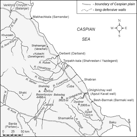
The Apzut Kawāt wall was a Sasanian defensive long wall mentioned by Anania Širakac‘i in the part of his geography dealing with the eastern Caucasus: “the long wall called Apzutkawat as far as the Alḷminon swamp and the sea” (Ananias of Shirak, p. 57; Moïse Corène, p. 27.9; tr., p. 37). The identification of the Apzut Kawāt wall, which derived its name from that of the ruling Sasanian monarch (MPers. *Abzūd Kawād, Kawād increased [in glory]” or “has prospered”), with the Ghilghilchay (Ḡilḡilčay/Gilgilçay) defensive wall was first made by S. T. Eremyan (p. 35), who attributed its construction to the reign of Kawād I (r. 488-531), and that opinion is now widely accepted. It is indirectly confirmed by the presence of extensive marshlands, known under the Azeri name Akh-zybyr (Ağzıbir), near the Caspian Sea in an area close to the eastern end of the Ghilghilchay wall. Masʿūdī described the building activity of Kawād I in the Eastern Caucasus and referred to “the walls that he had constructed in Šervān known as the Sur al-Ṭin [mortar walls], and the stone wall known as Barmaki” (Masʿudi, II, p. 74). It is possible to identify the Barmaki wall as the fortification near mount Besh-Barmak (Beşbarmaq) and the Sur al-Ṭin as the Ghilghilchay long wall (Figure 1).
The Ghilghilchay long wall is located in the Divichi (Dǝvǝçi) district of the Republic of Azerbaijan and derives its name from the name of the river, along which it extends for its initial 14 km. The width of the coastal plain in the immediate area of the wall measures from 7.7 to 8.7 km.
The ruins of the Ghilghilchay defensive wall were seen by William of Rubruck (chap. 50), who accompanied King Louis IX of France on the Seventh Crusade in 1248. The Russian scientist-naturalist, Samuel Gottlieb Gmelin (1745-1774) travelled to Iran along the western Caspian coast from 1770 to 1773. Later, one of his anonymous companions published a brief description of the journey, and in particular, provided information on the Ghilghilchay wall (in von Bieberstein, p. 17). The Russian historian P. G. Butkov (1175-1857), who participated in Valerian Zubov’s campaign in the eastern Caucasus in 1796, also was informed about the wall (II, p. 588). Another participant in Zubov’s campaign, F. F. Simonovich (1760-1815), compiled a “Description of Southern Daghestan” in which he lists information about the Ghilghilchay wall and one more name for it, Algun ibaru (p. 148). This name is rather interesting, but it is written incorrectly. It is more correctly rendered as Alguni baru (from Pers. bāru, wall/fortification of Algun). The Azerbaijani historian, philosopher, and poet Abbas-Kuliaga Bakikhanov (ʿAbbāsqoli Āqā Bākiḵānuf; 1794-1846) in his Golestān-e Eram (pp. 11-12) provided information on this wall and used its Persian name sadd-e Algun “Algun wall.” He wrote: “The remains of that wall and the place of the gate and the ruins of the city can still be seen on the west bank of the river Kalhin in the district of Shabaran of Qobbeh. The place of the fort above the hill on the right bank of the river still exists. This wall starts from the sea and from the top of the village of ʿAli Khanlu, which probably originally was Alghunlu, and is close to the said city; it joins with the fort called Cheragh. From there to the mountain Ateh, where the ruins of a big city are to be seen; it passes above the village of Qunaq kend and goes to Baba-daghi” (as tr. in Floor and Javadi, p.12; see also tr. and comm. Buniyatov, pp. 18, 44).
The first scientific visual observations of this wall were carried out in 1931-32 by E. A. Pakhomov, who incorrectly identified it with “the stone Barmaki wall” mentioned by Masʿudi (Pakhomov, pp. 40-43). Pakhomov gave a brief description of the Ghilghilchay long wall from the sea up to the Chirakh-kala (Çıraqqala) fortress, where he believed it ended. Pakhomov established some specific features of the building materials and the engineering construction of the wall and also provided one more local name of its coastal section, Iskender samti.
In 1963-64, this defensive line was visually inspected in its entirety by H. P. Abdullaev, who determined its length to be about 60 km from the sea up to the foot of mount Babadağ (3629 m). Abdullaev was inclined to date its construction to the 5th–6th centuries CE.
In 1980 the Ghilghilchay wall was examined by the archaeologists of the Institute of Archaeology and Ethnography of the Academy of Sciences of Azerbaijan, and the first excavation of the wall was carried out by A. A. Aliev (1984, pp. 64-70; 1985, pp. 50-1; 1986). The excavation was conducted along a section of the foothill part of the wall. In these excavations, 15 m of the defensive structure, including the wall and part of a tower, were cleared. The wall was constructed from mud bricks (dimensions 40-42 x 40-42 x 12 cm, 45 x 45 x 12 cm) laid successively on clay mortar. The wall was 4.15 m wide and 4.2-5.0 m high (up to 30 rows of bricks). The excavated section of the tower proved that it was solid (i.e., blind) and had a semicircular form advancing out from the line of the wall on both sides. The length of the advance on each side of the tower equaled 5.2 m; the width of the tower running parallel to the wall was about 7.0-7.3 m. The diameter of the semi-circular towers measured 5.7 m. Aliev determined that the Ghilghilchay wall extended for approximately 50 km.
In 2002, the Azerbaijani-Daghestani-American archaeological expedition carried out careful visual investigations of portions of the Ghilghilchay long wall. The investigation was first conducted on the flat coastal plain (about 6 km) and then followed the foothill portion (about 8 km) up to its crossing of the Ghilghilchay river (Aliev et al., pp. 143-77).
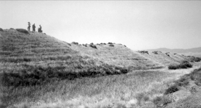
The coastal plain section of the Ghilghilchay long wall extends 6.0 km and ends with a large fortified settlement. What now remains of the Ghilghilchay wall begins about two km from the coast of the Caspian Sea and is visible as a low bank which has probably been deformed by transgressions and regressions of the Caspian Sea (Figure 2). Closer to the sea, the rest of the wall is not visible, but there are separate hills and heights. The present extent of the remaining coastal plain section of the wall measures approximately 5890 m. The wall follows a direct southwest line that blocks the coastal plain and comes to an end at the northeast corner tower of the mentioned settlement. The wall averages 3.5-5.0 m in height and 30 m wide at the base of the tower structures. Some sections of the wall measure 1.5-2.5 m in height and 6.0-7.0 m in width (at the beginning of the wall), while other sections reach heights of 6.0-7.0 meters. There are breaks at several places along the wall, the majority of which resulted from the modern construction of roads.
The remains of towers regularly arranged in the wall are easily distinguished. On the flat coastal plain, the remains of 135 towers are clearly visible. In several places, however, the towers and the wall are destroyed. The usual distance between towers is 36-40 m. The remains of the towers rise above the wall 1.0-2.0 m and jut out from its line on both sides as semicircular outcrops with diameters ranging from 10-14 m. The diameter of the large towers reaches up to 25 m. The largest tower on the flat coastal plain, Tower 117, has a height of about 10 m and a diameter at its base of approximately 40 m. This tower rises above the adjoining wall 2.5 m and, obviously, represented an important strategic point. The defensive wall appears to be entirely constructed of mud bricks measuring 42-43 x 42-43 x 12-13 cm on a 2 cm thick clay mortar with outside plaster measuring 2.5-3.0 cm thick. Pakhomov (p. 40) also noted the same formation of bricks, thick mortar, and outside plaster coating. Burnt bricks (measuring 37 x 37 x 7-8 cm and 37 x 37 x 10 cm) and cobblestones were also used in limited quantity in the construction of the wall. The thickness of the wall on the flat coastal plain measures approximately 8 m.
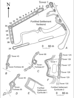
The coastal plain section of the Ghilghilchay long wall ended at a large fortress located approximately 0.4 km from the beginning of the foothills. The settlement has a trapezoidal shape, and its northern wall extends as if it is a continuation of the Ghilghilchay long wall. The size of the settlement is approximately 420 x 210 m. The earthen banks that cover the remains of the impressive defensive walls reach 5.0-7.0 m in height and measure 30-36 m in width at their base. The northern and western walls provide the best security, and the remains of towers on these sections appear as semicircular outcrops (d=10-12 m) rising above the wall 0.5-1.5 m. The towers on the northeast and northwest corners are visible as large hills reaching heights of about 10 m with diameters at their bases of about 35 m. The northern wall is the most heavily fortified. Here, 14 towers are located along a 396 m long wall. The distance between towers is not regular and changes from 12.5-13.5 m up to 36 m. Between Towers 4 and 5, there is a break that is approximately 6 m wide, which probably was the ancient gate of the settlement (Figure 3).
The foothill section of the Ghilghilchay long wall is visible beginning 800 m to the south of the described settlement above the contemporary highway. Here, the wall is clearly visible in cross-section, revealing its construction entirely of mud bricks (40-43 x 40-43 x 12 cm). The thickness of the wall here measures approximately 6 m with a remaining height of approximately 2.3 m. The foothill section of the wall follows a south-southwest trajectory, but it changes direction sharply at various points as it conforms to the course of the high river terrace. Its dimensions are significantly smaller than the coastal plain section of the wall, and it is obvious that this difference in size is not so much a question of the wall’s preservation along this section, as it is of its real dimensions. That is, the foothill section of the mud-brick wall was smaller than that built on the coastal plain. The foothill portion of the wall was additionally strengthened by its location on top of the natural terrace ridge.
On this foothill section, there are 140 towers connected by a wall averaging 2.0-2.5 m high and 8.0-12.0 m wide. The distance between towers on this portion changes to a general range of 37-52 m. The remains of towers jut out from the wall on both sides and have, generally, the appearance of small barrows (h=2.5-3.5 m; d=5-18 m), rising above the wall 0.5-1.3 m. Toward the end of the foothill section the ruins of the wall and towers are larger. The wall here is 4.0-5.5 m high with towers rising to 6.0-6.5 m in overall height. There are three big towers-garrisons, fixing the presence of an internal room, and three rectangular fortified settlements, measuring about 45 x 60 m, 120 x 90 m and 28 x 25 m. The last settlement is on the lower terrace of the Ghilghilchay river where the channel narrows to 50-60 m. The remains of fragments of burnt brick (6.0-7.5 cm thickness) masonry on lime mortar indicate that there had been a bridge across the river here (Pakhomov, 1933, p. 42). The remains of the mountain portion of the Ghilghilchay defensive wall begin on the opposite coast of the river on a mountain spur that descends down to the riverbed. The remains of the wall extend farther to the west up to the Chirakh-kala fortress at the top of the mountain range and then to the foot of mount Babadağ.
Ceramic assemblage of the fortifications of the Ghilghilchay long wall, as well as the building materials and engineering features of this defensive system gives a possible date for the construction of the Ghilghilchay wall to the 5th-6th centuries CE. The identification of the Ghilghilchay defensive line with the long wall Apzut Kawāt, mentioned by Ananias of Shirak, which received its name in honor of the reigning monarch, is sufficiently reliable. This enables us to attribute the construction of the Ghilghilchay wall to the time of the reign of Kawād I. A more exact time of construction can be determined by considering the political situation in the Caucasus and the Near East. The most favorable conditions for the construction of such an extensive defensive system existed in the period between 508 and 522 CE when Iran had peace with Byzantium and had established allied relations with the northern Caucasian Huns-Sabirs and had regained control of the eastern Caucasus and the Darband corridor (Aliev et al., pp. 174-175; Gadjiev, 2006, pp. 25-26; 2009).
Bibliography:
Sources
Ananias of Širak, Ašxarhacʻoycʻ, tr. R. H. Hewsen with introd. and comm. as The Geography of Ananias of Širak (Ašxarhacʻoycʻ):The Long and the Short Recensions, Wiesbaden, 1992.
A.-K. Bakikhanov, Golestān-e Eram, ed. ʿA.-K. ʿAlizāda et al., Baku, 1970 (Persian text); ed. and tr. Z. M. Buniyatov as Gülistan-i Iram, Baku, 1991 (Russian translation with commentary and notes); tr. W. Floor and H. Javadi as The Heavenly Rose-Garden: A History of Shirvan & Daghestan, Washington, D.C., 2009.
Friedrich A. M. von Bieberstein, Tableau des provinces sitées sur la côte occidentale de la mer Caspienne, entre les fleuves Terek et Kour, St. Peterbourg, 1798.
P. G. Butkov, Materialy dlja novoĭ istorii Kavkaza, s 1722 po 1803 god (Materials for a modern history of the Caucasus from 1722 to 1803), 3 vols., St. Petersburg, 1869.
Abu’l-Ḥasan ʿAli Masʿudi, Moruj al-ḏahab, ed. and tr. Charles Barbier de Meynard and Abel Pavet de Courteille as Les prairies d’or, 9 vols., Paris, 1861-1917.
Moïse de Corène [Movsēs Xorenacʿi], Géographie de Moïse Corène d’après Ptolémée, ed. and tr. A. Soukry, Venice, 1881.
William of Rubruck, The Mission of Friar William of Rubruck: His Journey to the Court of the Great Khan Möngke, 1253-1255, tr. P. Jackson with D. Morgan, London, 1990.
F. F. Simonovich, “Opisanie Iuzhnogo Dagestana. 1796 god” (Description of southern Daghestan 1796), in M. O. Kosven and Kh.-M. Khashaev,eds., Istoriya, geografiya i etnografiya Dagestana XVIII-XIX vekov: arkhivnye materialy (History, geography and ethnography of Daghestan, XVIII-XIX centuries: archival materials), Moscow, 1958, pp. 138-56.
Studies
H. P. Abdullaev, “Gil’gil’chaiskaia oboronitel’naia stena i krepost’ Chirakh-kala” (Ghilghilchay defensive wall and fortress Chirakh-kala), Sovetskaya arkheologiya 2, 1968, pp. 196-209.
A. A. Aliev, “Arkheologicheskie raskopki Gil’gil’chaiskogo oboronitel’nogo sooruzheniya” (Archaeological excavations of Ghilghilchay fortification), Izvestiya Akademii nauk Azerbaidzhanskoi SSR. Seriia istorii, filosofii i prava 3, 1984, pp. 64-70.
Idem, “Ob oboronitel’nyh sooruzheniiah Kavkazskoi Albanii” (On the defensive structures of Caucasian Albania) in Vsesoiuznaia arkheologicheskaia konferentsiya: Tezisy dokladov (All-Union Archaeological Conference: abstracts of papers), Baku, 1985, pp. 50-51.
Idem, Gil’gil’chaiskoe oboronitel’noe sooruzhenie (The Ghilghilchay defensive structure), Baku, 1986, pp. 1-15.
A. A. Aliev et al., “The Gilgilchay Long Defensive Wall: New Investigations,” Ancient East and West 5/1-2, 2006, pp. 143-77.
S. T. Eremyan, “Syunia i oborona Sasanidami kavkazskih prohodov” (Siwnik‛ and the Sasanian defense of the Caucasian passages) in Izvestiya Armianskogo filiala Akademii nauk SSSR 7, 1941, pp. 33-40.
M. S. Gadjiev, “Etapi gradostrinel’noi i fortifikatsionnoi deiatel’nosti Sasanidov na Vostochnom Kavkaze” (Stages of city-planning and fortification activity of the Sasanians in the Eastern Caucasus), Irano-Dagestanskie kul’turnie i istoricheskie sviazi: istoriya i perspektivi razvitiya (Iran-Daghestan cultural and historical ties: history and development prospects), Makhachkala, 2006, pp. 24-38.
Idem, “Hunok és türkök támadásai és a Szaszanidák erdítési tevékenysége a Kelet-Kaukázusban” (Hunno-Turkic attacks and Sasanian fortification activity in the eastern Caucasus) in L. Marácz and B. Obrusánszky, eds., A Hunok öröksege (The Heritage of the Huns), Budapest, 2009, pp. 239-64.
E. A. Pakhomov, “Krupneishie pamiatniki sasanidskogo stroitel’stva v Zakavkaz’e” (The largest monuments of Sasanian construction in Transcaucasia), Problemi istorii material’noi kul’turi 9-10, 1933, pp. 37-47.
(Murtazali Gadjiev)
Originally Published: May 30, 2017
Last Updated: May 30, 2017
Cite this entry:Murtazali Gadjiev, “APZUT KAWĀT WALL,” Encyclopædia Iranica, online edition, 2017, available at http://www.iranicaonline.org/articles/apzut-kawat-wall (accessed on 30 May 2017).